
Zekharia: Difference between revisions
Onceinawhile (talk | contribs) No edit summary |
Not intro-worthy |
||
| Line 1: | Line 1: | ||
{{Infobox Israel village |
{{Infobox Israel village |
||
|name |
| name = Zekharia |
||
|image |
| image = Israeli town of Bayt Zakariah, June 2015.jpg |
||
|caption= |
| caption = |
||
|hebname |
| hebname = זכריה |
||
| ⚫ | |||
|arname=زخاريا |
|||
| ⚫ | |||
| ⚫ | |||
| ⚫ | |||
| ⚫ | |||
| ⚫ | |||
| ⚫ | |||
| ⚫ | |||
| ⚫ | |||
| ⚫ | |||
| ⚫ | |||
| |
| population = {{Israel populations|Zekharya}} |
||
| |
| population_footnotes= {{Israel populations|reference}} |
||
| ⚫ | |||
| ⚫ | |||
| ⚫ | |||
| ⚫ | |||
| ⚫ | |||
| ⚫ | |||
| ⚫ | |||
}} |
}} |
||
'''Zekharia''' ({{lang-he|זְכַרְיָה}}) is a [[moshav]] in central [[Israel]]. |
'''Zekharia''' ({{lang-he|זְכַרְיָה}}) is a [[moshav]] in central [[Israel]]. Located near [[Beit Shemesh]], it falls under the jurisdiction of [[Mateh Yehuda Regional Council]]. In {{Israel populations|Year}} it had a population of {{Israel populations|Zekharya}}. |
||
==Geography== |
==Geography== |
||
Revision as of 21:20, 22 February 2023
Zekharia
זכריה | |
|---|---|
 | |
 Zekharia | |
| Coordinates: 31°42′35″N 34°56′42″E / 31.70972°N 34.94500°E | |
| Country | Israel |
| District | Jerusalem |
| Council | Mateh Yehuda |
| Affiliation | Moshavim Movement |
| Founded | 1950 |
| Founded by | Kurdish Jews |
| Population (2022)[1] | 1,125 |
Zekharia (Hebrew: זְכַרְיָה) is a moshav in central Israel. Located near Beit Shemesh, it falls under the jurisdiction of Mateh Yehuda Regional Council. In 2022 it had a population of 1,125.
Geography
Zekharia is located off the road between Beit Guvrin and the Jerusalem-Jaffa highway. It is 268 meters above sea level. It is bordered on the southeast by the Elah Valley, about 5 kilometres (3.1 mi) southwest of Beit Shemesh. The mountain of Azekah can be seen directly to the south of the village.
History
Antiquity
Beth Zacharia (on a nearby hill) is said to have existed in Roman times.[2][citation needed] According to legend, the body of the prophet Zechariah was found here in 415 CE and a church and monastery were established in the lower village by the same name.[3] The Madaba Map displays the lower town as the burial site of the prophet Zechariah.[4]
Mamluk period
Under the Mamluks, the village was a dependency of Hebron, and formed part of the waqf supporting the Ibrahimi Mosque.[5] The villagers obtained their drinking water from two communal wells:- al-Saflani well which was drilled next to Wadi 'Ajjur, and al-Sarara well located north of the village.[6]
Ottoman period
In 1596, during the early Ottoman period, the village of Zakariyya al-Battikh had a population of 47 households and was part of the nahiya of Quds (Jerusalem).[3] It was a Palestinian village in the Jerusalem corridor under the administrative jurisdiction of Bayt Jibrin.[citation needed]
State of Israel
In the 1948 Arab–Israeli War, Az-Zakariyya was the longest lasting Arab community in the southern Jerusalem Corridor.[7] The villagers were evicted by the Israelis in three different phases, last eviction was carried out on June 9, 1950, on the orders of David Ben-Gurion, Moshe Sharett and Yosef Weitz, and most ended up on the-then Jordanian-occupied West Bank.[8]
In 1950 Moshav Zekharia was established by Kurdish Jewish immigrants on the village site.[9] During the 1960s, most of the older buildings in the village were decrepit and unsafe and had to be demolished to make room for new, safer housing.[10]

In 1992, Walid Khalidi described the remaining structures of the Arab village: "The mosque and a number of houses, some occupied by Jewish residents and others deserted, remain on the site. Large sections of the site itself are covered with wild vegetation. The mosque is in a state of neglect and an Israeli flag is planted on top of the minaret. [..] One of the occupied houses is a two-storey stone structure with a flat roof. Its second story windows have round arches and grillwork. Parts of the surrounding lands are cultivated by Israeli farmers."[9]
Landmarks
The tomb of Zecharia, which has been attributed to both the Hebrew prophet Zecharia and Zechariah, father of John the Baptist, is located on the moshav,[11] within the mosque.[12] The site is mentioned in sources as early as the fourth century, in the writings of Sozomenos, and it appears on the Madaba map.[11]
In the 1970s, there was a resurgence of Jewish interest in the site, which became a pilgrimage destination for Jews from Iraq, Iran, Cochin and elsewhere in India, and elsewhere, who prayed there and lit candles.[11]
Gallery
-
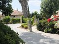 Homes in Moshav Zekharia
 -
 Remains of a minaret and mosque
 -
![Az-Zakariyya, pre-1926[13]](//upload.wikimedia.org/wikipedia/commons/thumb/4/4f/Zachariah2.jpg/83px-Zachariah2.jpg) Az-Zakariyya, pre-1926[13]
Az-Zakariyya, pre-1926[13] -
 Main synagogue
 -
 View from southeast and the Elah Valley
 -
 Residential neighborhood on adjacent hilltop
 -
 House in Zekharia
 -
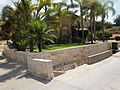
 Public park


![Az-Zakariyya, pre-1926[13]](/wiki/File:Zachariah2.jpg)


References
- ^ "Regional Statistics". Israel Central Bureau of Statistics. Retrieved 21 March 2024.
- ^ Josephus, Antiquities (Book xii, chapter ix, verse 4)
- ^ a b Petersen (2001), p. 320
- ^ See p. 138 in: Tsafrir, Yoram (1986). "The Maps Used by Theodosius: On the Pilgrim Maps of the Holy Land and Jerusalem in the Sixth Century C.E.". Dumbarton Oaks Papers (Trustees for Harvard University). 40: 129–145. doi:10.2307/1291534. JSTOR 1291534.
- ^ Mujir al-Din, "The glorious history of Jerusalem and Hebron" (c. 1495), translated to French by Henry Sauvaire, "Histoire d'Jérusalem et d'Hébron", Paris: Ernest Leroux (1876), p. 231. Cited and translated to English in Petersen (2001), p. 320
- ^ Khalidi, 1992, pp. 224–225
- ^ Morris, 2004, p. 521
- ^ Mordechai Bar-On, officer in charge of the eviction. Quoted in Morris, 2004, p. 521
- ^ a b Khalidi, 1992, p. 226
- ^ Arnon Shai (2006). "The Fate of Abandoned Arab Villages in Israel, 1965-1969". History and Memory. 18 (2): 86–106. doi:10.2979/his.2006.18.2.86.
- ^ a b c Marshall J. Breger, Yitzhak Reiter and Leonard Hammer, ed. (2013). Sacred Space in Israel and Palestine: Religion and Politics. Routledge. p. 150. ISBN 9781136490330. Retrieved 9 August 2021.
- ^ Benvenisti, M.; Kaufman-Lacusta, M. (2000). Sacred Landscape: The Buried History of the Holy Land Since 1948. Honorable Mention for the Albert Hourani Award, Middle Easte. University of California Press. p. 289. ISBN 978-0-520-23422-2. Retrieved 2022-08-27.
At Moshav Zakariyya, not far from Beit Shemesh in the Shephelah, stands the neglected building of the village mosque, within which is located the grave of Zachary
- ^ Khalidi, 1992, p. 206
Bibliography
- Khalidi, Walid (1992). All That Remains: The Palestinian Villages Occupied and Depopulated by Israel in 1948. Washington D.C.: Institute for Palestine Studies. ISBN 978-0-88728-224-9.
- Morris, Benny (2004). The Birth of the Palestinian Refugee Problem Revisited. Cambridge: Cambridge University Press. ISBN 978-0-521-00967-6.
- Petersen, Andrew (2001). A Gazetteer of Buildings in Muslim Palestine (British Academy Monographs in Archaeology). Vol. 1. Oxford University Press. ISBN 978-0-19-727011-0.
External links
![]() Media related to Zecharia (Moshav) at Wikimedia Commons
Media related to Zecharia (Moshav) at Wikimedia Commons