
List of European countries by area: Difference between revisions
Content deleted Content added
No edit summary |
No edit summary |
||
| Line 153: | Line 153: | ||
{{Europe and seas labelled map}} |
{{Europe and seas labelled map}} |
||
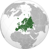
Map of Europe, showing one of the most commonly used [[boundaries between the continents|continental boundaries]]{{efn|The map shows one of the most commonly accepted delineations of the geographical boundaries of Europe, as used by [[National Geographic Society|National Geographic]] and [[Encyclopædia Britannica]]. Whether countries are considered in Europe or Asia can vary in sources, for example in the classification of the [[The World Factbook|CIA World Factbook]] or that of the [[BBC]]. Certain countries in Europe, such as France, have [[List of transcontinental countries#Non-contiguous|territories lying geographically outside Europe]], but which are nevertheless considered integral parts of that country.}} |
Map of Europe, showing one of the most commonly used [[boundaries between the continents|continental boundaries]]{{efn|The map shows one of the most commonly accepted delineations of the geographical boundaries of Europe, as used by [[National Geographic Society|National Geographic]] and [[Encyclopædia Britannica]]. Whether countries are considered in Europe or Asia can vary in sources, for example in the classification of the [[The World Factbook|CIA World Factbook]] or that of the [[BBC]]. Certain countries in Europe, such as France, have [[List of transcontinental countries#Non-contiguous|territories lying geographically outside Europe]], but which are nevertheless considered integral parts of that country.}} |
||
Legend: |
Legend: |
||
<span style="color:blue;">'''Blue'''</span> = [[List of transcontinental countries#Contiguous boundary|Contiguous transcontinental countries]]<br /> |
<span style="color:blue;">'''Blue'''</span> = [[List of transcontinental countries#Contiguous boundary|Contiguous transcontinental countries]]<br /> |
||
<span style="color:green;">'''Green'''</span> = Sometimes considered European but geographically outside Europe's boundaries |
<span style="color:green;">'''Green'''</span> = Sometimes considered European but geographically outside Europe's boundaries |
||
Revision as of 22:43, 4 December 2023
Below is a list of countries and dependencies in Europe by area.[1] As a continent, Europe's total geographical area is about 10 million square kilometres.[2] Transcontinental countries are ranked according to the size of their European part only. Inland water is included in area numbers.
List of European countries and dependencies by area
| Country or dependency | % total |
Europe Area | |||
|---|---|---|---|---|---|
| (km2) | (mi2) | ||||
| Europe | 100% | 10,011,000 | 3,865,000 | ||
| 1 T | 39.5% | 3,952,550 | 1,526,090 | [a] | |
| 2 | 6.0% | 603,549 | 233,032 | [b] | |
| 3 T | 5.4% | 543,941 | 210,017 | [c] | |
| 4 T | 5.0% | 498,485 | 192,466 | [d] | |
| 5 | 4.4% | 438,574 | 169,334 | ||
| 6 | 3.6% | 357,581 | 138,063 | ||
| 7 | 3.4% | 336,884 | 130,072 | [e] | |
| 8 | 3.2% | 323,772 | 125,009 | [f] | |
| 9 | 3.1% | 312,679 | 120,726 | ||
| 10 T | 3.0% | 301,958 | 116,587 | [g] | |
| 11 | 2.4% | 244,376 | 94,354 | [h] | |
| 12 | 2.4% | 238,298 | 92,007 | ||
| 13 | 2.1% | 207,600 | 80,200 | ||
| 14 T | 1.5% | 148,000 | 57,000 | [i] | |
| 15 | 1.3% | 131,957 | 50,949 | ||
| 16 | 1.1% | 110,372 | 42,615 | ||
| 17 | 1.0% | 103,000 | 40,000 | ||
| 18 | 0.9% | 93,025 | 35,917 | ||
| 19 T | 0.9% | 91,421 | 35,298 | [j] | |
| 20 | 0.8% | 83,878 | 32,385 | ||
| 21 | 0.8% | 78,871 | 30,452 | ||
| 22 | 0.8% | 77,589 | 29,957 | [k] | |
| 23 | 0.7% | 69,825 | 26,960 | ||
| 24 | 0.7% | 65,286 | 25,207 | ||
| 25 | 0.6% | 64,594 | 24,940 | ||
| 26 | 0.6% | 56,594 | 21,851 | ||
| 27 | 0.5% | 51,209 | 19,772 | ||
| 28 | 0.5% | 49,035 | 18,933 | ||
| 29 | 0.5% | 45,399 | 17,529 | ||
| 30 | 0.4% | 42,947 | 16,582 | ||
| 31 T | 0.4% | 41,543 | 16,040 | [l] | |
| 32 | 0.4% | 41,291 | 15,943 | ||
| 33 | 0.3% | 33,847 | 13,068 | ||
| 34 | 0.3% | 30,528 | 11,787 | ||
| 35 | 0.3% | 28,748 | 11,100 | ||
| 36 | 0.3% | 25,713 | 9,928 | ||
| 37 | 0.2% | 23,757 | 9,173 | [m] | |
| 38 | 0.2% | 20,273 | 7,827 | ||
| 39 | 0.1% | 13,888 | 5,362 | ||
| 0.1% | 10,910 | 4,210 | [n] | ||
| 40 T | 0.07% | 6,960 | 2,690 | [o] | |
| 4,163 | 1,607 | [p] | |||
| 41 | 0.03% | 2,586 | 998 | ||
| 0.03% | 2,530 | 980 | [q] | ||
| 0.02% | 1,583 | 611 | [r] | ||
| 0.01% | 1,393 | 538 | |||
| 0.006% | 572 | 221 | |||
| 42 | 0.005% | 468 | 181 | ||
| 43 | 0.003% | 315 | 122 | ||
| 44 | 0.002% | 160 | 62 | ||
| 0.001% | 116 | 45 | |||
| 0.001% | 64 | 25 | |||
| 45 | 0.001% | 61 | 24 | ||
| 0% | 7 | 2.7 | [s] | ||
| 45 | 0% | 2 | 0.77 | [t] | |
| 47 | 0% | 0 | 0 | [u] | |
| C | (8,665) | (3,346) | [v] | ||
| 48 C | (69,700) | (26,911) | [w] | ||
| C | (3,900) | (1,506) | [x] | ||
| C | 0% | (254) | (98) | [y] | |
| 49 C | 0% | (29,743) | (11,484) | [z] | |
| C | 0% | (3,170) | (1,224) | [aa] | |
| 49 C | 0% | (9,251) | (3,572) | [ab] | |
| C | 0% | (2,166,086) | (836,327) | [ac] | |
| C | 0% | (3,355) | (1,295) | [ad] | |
Definition
Europe and Asia are contiguous with each other; thus, the exact boundary between them is not clearly defined, and often follows historical, political, and cultural definitions, rather than geographical.

Map of Europe, showing one of the most commonly used continental boundaries[ae]
Legend:
Blue = Contiguous transcontinental countries
Green = Sometimes considered European but geographically outside Europe's boundaries
See also
- Area and population of European countries
- List of countries and dependencies by area
- List of European countries by population
Notes
- ^ Comprising European Russia. Excludes annexations that are internationally recognized as part of Ukraine. Total area is 17,035,650 km² when including North Asia (13,083,100 km²).[3]
- ^ Includes Crimea (26,945 km²) and other territory annexed by Russia but internationally recognized as part of Ukraine.[4]
- ^ Mainland France (535,261 km²) and Corsica ( 8,680 km²) comprise European France or Metropolitan France. Total area is 633,109 km² when including Overseas departments (89,168 km²).[5]
- ^ Excluding Ceuta (19 km²), Melilla (12 km²), and the Canary Islands (7,493 km²). Total area is 506,009 km².[6]
- ^ Excludes Aland.
- ^ Excludes Svalbard.
- ^ Excluding the African islands of Pantelleria (25 km²) and Lampedusa e Linosa (85 km²). Total area including these is 302,068 km².[7][8]
- ^ Constituent countries have area 130,267 km² (England), 13,511 km² (Northern Ireland), 78,286 km² (Scotland) and 20,700 km² (Wales).[9]
- ^ European portion is about 5% of total area, with the rest in Central Asia. Nine districts are entirely in Europe, but the Ural river runs through the middle of four districts (Akzhaik, Inder, Makhambet, and Atyrau). Value given is a point estimate between entirely excluding (122,176 km²) or including (174,814 km²) these four districts. Overall area is 2,724,902 km².[10]
- ^ Excluding Madeira (801 km²). Total area is 92,225 km².[11]
- ^ Area is from official figures, but excluding Kosovo.[12] UN population figure also excludes Kosovo.
- ^ Area is 34,651 km² when including the Caribbean Netherlands (322 km²).[13]
- ^ European Turkey or East Thrace comprises the entire provinces of Tekirdağ, Kırklareli and Edirne, as well as the portion of Istanbul Province west of the Bosporus Strait and the portion of Çanakkale Province north of the Dardanelles Strait.[14] Total area is 769,734 km² when including Asia Minor or Anatolia (745,978 km²).
- ^ A partially recognized state also claimed by Serbia. Area is from official figures.[15]
- ^ The Guba-Khachmaz Economic Region comprises Azerbaijan's land north of the Caucasus. Some definitions of the Europe-Asia border place more of Azerbaijan in Europe. Total area is 86,600 km².[16]]]
- ^ De facto state with limited recognition. Internationally recognized as part of Moldova.[17]
- ^ An integral part of Norway. Classified as a territory by the ISO 3166-1, which groups it with Jan Mayen.
- ^ An integral but autonomous region of Finland. Classified as a territory by the ISO 3166-1.
- ^ Figures are from the BBC.[18]
- ^ Area and population are from official figures.[19]
- ^ The De Agostini Atlas Calendar listed the area of Vatican City as 0.44 km² in its 1930 edition[20] but corrected it to 0.49 km² in its 1945–46 edition.[21] The figure of 0.44 km2 is still widely cited by many sources despite its inaccuracy.
- ^ An unknown portion may lie north of the Caucasus, so total figures are given.[22] De facto state with limited recognition. Internationally recognized as part of Georgia.
- ^ An unknown portion may lie north of the Caucasus, so total figures are given. Excluding Abkhazia and South Ossetia.[23] Some definitions place the Europe-Asia border inside of Georgia.
- ^ An unknown portion may lie north of the Caucasus, so total figures are given.[24] De facto state with limited recognition. Internationally recognized as part of Georgia.
- ^ Culturally but often not geographically in Europe, so total figures are given. Part of the island of Cyprus.[25]
- ^ Culturally but often not geographically in Europe, so total figures are given.
- ^ Total figures given. Formerly a de facto state also claimed by Azerbaijan, which took control of the region in late 2023. Will be formally abolished at end of 2023.
- ^ Culturally but often not geographically in Europe, so total figures are given. Not including Northern Cyprus or Akrotiri and Dhekelia.[26]
- ^ Culturally tied to Europe but not a geographic part of it, so total figures are given.
- ^ Culturally but often not geographically in Europe, so total figures are given. Part of the island of Cyprus and claimed by the state of Cyprus.[27][28]
- ^ The map shows one of the most commonly accepted delineations of the geographical boundaries of Europe, as used by National Geographic and Encyclopædia Britannica. Whether countries are considered in Europe or Asia can vary in sources, for example in the classification of the CIA World Factbook or that of the BBC. Certain countries in Europe, such as France, have territories lying geographically outside Europe, but which are nevertheless considered integral parts of that country.
References
- ^ Source unless otherwise specified: Demographic Yearbook – Table 3: Population by sex, rate of population increase, surface area and density (PDF) (Report). United Nations Statistics Division. 2021. Retrieved 21 May 2023. Entries in this table giving figures other than the figures given in this source are explained in the associated Note.
- ^ "Map and Details of all 7 Continents". WorldAtlas. Retrieved 4 May 2019.
- ^ "Russia : Administrative Division". City Population. 8 Oct 2022. Retrieved 29 Oct 2023.
- ^ "Ukraine: Provinces and Major Cities". City Population. 22 Oct 2022. Retrieved 29 Oct 2023.
- ^ "France: Administrative Division". City Population. 28 Jan 2022. Retrieved 29 Oct 2023.
- ^ "Population by Autonomous Community and Autonomous City and sex". ine.es. Retrieved 29 Oct 2023.
- ^ "Monthly demographic balance and resident population by sex, year 2023". istat.it. Retrieved 29 Oct 2023.
- ^ "Main geographical statistics on municipalities". istat.it. 22 Jan 2013. Municipal and provincial data. Retrieved 29 Oct 2023.
- ^ "Population estimates for the UK, England, Wales, Scotland and Northern Ireland: mid-2021". ons.gov.uk. 21 Dec 2022. Retrieved 29 Oct 2023.
- ^ "Kazakhstan: Administrative Division". City Population. 11 Dec 2022. Retrieved 29 Oct 2023.
- ^ "Statistics Portugal". ine.pt. Retrieved 29 Oct 2023.
- ^ "Serbia : Regions, Districts and Major Cities". City Population. 28 May 2023. Retrieved 5 Nov 2023.
- ^ "Netherlands : Major Urban Centers". City Population. 15 Sep 2022. Retrieved 28 Oct 2023.
- ^ "Turkey: Administrative Division". City Population. 12 Feb 2023. Retrieved 5 Nov 2023.
- ^ "Kosovo". City Population. 7 Sep 2023. Retrieved 5 Nov 2023.
- ^ "Territories, number and density of population by economic and administrative regions of the Republic of Azerbaijan". The State Statistical Committee of the Republic of Azerbaijan. 2021. Retrieved 24 April 2022.
- ^ "Transnistria profile". bbc.com. 22 May 2023. Retrieved 3 Dec 2023.
- ^ "Gibraltar profile". BBC. 19 May 2023. Retrieved 28 Oct 2023.
- ^ "Key Facts About Monaco". Embassy of Monaco in Washington DC. 2020. Retrieved 28 Oct 2023.
- ^ De Agostini Atlas Calendar, 1930, p. 99. (in Italian)
- ^ De Agostini Atlas Calendar, 1945–46, p. 128. (in Italian)
- ^ "Georgia: Abkhazia". City Population. 14 Jan 2021. Retrieved 29 Oct 2023.
- ^ "Georgia: Administrative Division". City Population. 14 Jan 2021. Retrieved 29 Oct 2023.
- ^ "Georgia: South Ossetia". City Population. 14 Jan 2021. Retrieved 29 Oct 2023.
- ^ "Akrotiri and Dhekelia". City Population. 4 Aug 2023. Retrieved 29 Oct 2023.
- ^ "Cyprus". City Population. 4 Aug 2023. Retrieved 29 Oct 2023.
- ^ Muhammet İkbal Arslan (10 October 2022). "KKTC'nin nüfusu 382 bin 836 olarak hesaplandı" (in Turkish). Anadolu Agency.
- ^ "Northern Cyprus". City Population. 30 Nov 2020. Retrieved 29 Oct 2023.