
Talk:Piri Reis map: Difference between revisions
Doug Weller (talk | contribs) |
|||
| Line 135: | Line 135: | ||
:::I don't know what you mean by 'this page', but if you mean the article, no, your comments should not go there as Wikipedia is an encyclopedia reporting what verifiable and reliable sources say about a subject, see [[WP:RS]]. Meanwhile, see [http://www.sacred-texts.com/piri/pirikey.htm]. Note that he and the Egerton map use the word Antilia to refer to the New World continental mainland (on the portion of his map copied from a non-Columbian post-1504 map) as well as the legendary island. McIntosh suggests this may be because he used both 15th c. portolan charts showing an island of Antilia in the Atlantic and early 16th c. maps which name the western continent Antilia. By the way, it isn't located in the Caribbean Sea but in the Atlantic. What he wrote is "And this island they call the Island of Antilia. There are many monsters and parrots and much logwood. It is not inhabited." [[User:Dougweller|dougweller]] ([[User talk:Dougweller|talk]]) 19:43, 6 November 2008 (UTC) |
:::I don't know what you mean by 'this page', but if you mean the article, no, your comments should not go there as Wikipedia is an encyclopedia reporting what verifiable and reliable sources say about a subject, see [[WP:RS]]. Meanwhile, see [http://www.sacred-texts.com/piri/pirikey.htm]. Note that he and the Egerton map use the word Antilia to refer to the New World continental mainland (on the portion of his map copied from a non-Columbian post-1504 map) as well as the legendary island. McIntosh suggests this may be because he used both 15th c. portolan charts showing an island of Antilia in the Atlantic and early 16th c. maps which name the western continent Antilia. By the way, it isn't located in the Caribbean Sea but in the Atlantic. What he wrote is "And this island they call the Island of Antilia. There are many monsters and parrots and much logwood. It is not inhabited." [[User:Dougweller|dougweller]] ([[User talk:Dougweller|talk]]) 19:43, 6 November 2008 (UTC) |
||
==What part is supposed to be Antarctica?== |
|||
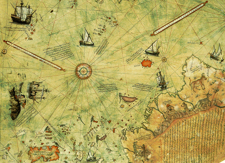
I can't tell what part is supposedly Antarctica. What part is the southern landmass? It is all connected together.--[[Special:Contributions/72.39.35.178|72.39.35.178]] ([[User talk:72.39.35.178|talk]]) 04:29, 3 December 2008 (UTC) |
|||
Revision as of 04:29, 3 December 2008
| This is the talk page for discussing improvements to the Piri Reis map article. This is not a forum for general discussion of the article's subject. |
Article policies
|
| Find sources: Google (books · news · scholar · free images · WP refs) · FENS · JSTOR · TWL |
| Archives: 1 |
| Turkey B‑class Mid‑importance | ||||||||||
| ||||||||||
| Paranormal Start‑class | ||||||||||
| ||||||||||
- This article has been renamed as the result of a move request. From Piri Reis Map to Piri Reis map. –Hajor 20:15, 13 October 2005 (UTC)
General
This entry definitely needs to be NPOVed. All that is presented here assumes that Hapgood's claims are valid -- the other side definitely needs to be voiced as well. I will make some minor changes now and aim for something more substantial in the future. In the meantime, other contributors should revise and expand what's here as well. --Varenius 20:41, 20 Jun 2005 (UTC)
Man, what happened to this thing?!! This article has been so severely gutted that the list of links is now longer than the body of text! I agree that Hapgood's claims about the map are arguably more appropriate for the article on him, but still, this piece has now been virtually reduced to a stub. I just finished beefing it up a little bit, but it still needs more expansion. If we don't want to go into the more "fringe" claims about the map, we should at least add more material about its connection to portolan charts, speculation about the original size of the map, etc. --Varenius 20:05, 1 August 2005 (UTC)
Criticisms of Antartica claim
An anonymous editor (24.168.5.223), added an entire paragraph of criticism, without citing a single source. I have reduced its absolute tone to one of conjecture, and left questions inline which should be answered in order for the paragraph to remain at all, specifically,
Lastly, the claim that the map depicts a portion of the ancient Antarctican landmass has certain criticisms <!--by whom?-->. Firstly, the map is large-scale and low-detail, and the landmass pictured is arguably not accurate enough to be matched to any actual landscape. Secondly, any similarity it may have to modern radar imaging of the Antarctica under the ice may be irrelevant, since in the period when Antartica was not covered with an ice cap its shorelines may be so different as to be completely unrecognizable, due to the pre-icecap sea level being significantly higher, and thus obscuring a great portion of the sixth continent. <!--where is this hypothetical shoreline image?-->
It is an interesting criticism, but more than borders on original research without citations. Invitation to comment left on 24.168.5.223talk page. -SM 07:40, 2 December 2005 (UTC)
I think the language in this part could be changed: "...a southern landmass that some controversially claim is evidence..." doesn't feel very NPOV. Kesshaka 00:39, 13 September 2007 (UTC)
- Why? It's a patently ridiculous claim on its face, and deserves to be taken far less seriously here than it already is. As is usual when you pit pseudoscience against science. TCC (talk) (contribs) 22:29, 13 September 2007 (UTC)
I've just removed a sentence stating that the "problems" of the depiction of South America / Antarctica were "explored in detail by Charles Hapgood". I had been tempted to replace "explored" by "created", since he originated the "ice-free" Antarctic theory- but instead I've just rearranged some of the material that offers alternative explanations for the features as depicted. David Trochos (talk) 07:59, 28 February 2008 (UTC)
About the claim "The map is from the Colombus map.."
I happened to know that the map is 10 year older than the time when Colombus step foot to hispaniola, is it right?
- Another source regarding the map compared to accurate modern charts: http://xoomer.alice.it/dicuoghi/Piri_Reis/PiriReis_eng.htm Eban 20:59, 2 June 2006 (UTC)
Columbus first stepped foot on Hispaniola in 1492, according to his log of his first voayge. The Piri Reis map was made in March and/or April of 1513, according to Piri's inscription on his map. How did you come to believe that the 1513 map was made 10 years before 1492?
Greg McIntosh?
Who is Greg McIntosh? A scholar, or just some guy off the street? Whoever wrote the section referring to him needs to give it more context. --Varenius 23:09, 12 April 2006 (UTC)
I see that Gregory McIntosh is now making some changes himself. I feel underqualified now ... He is the author of a book on the map that seems to represent the current scholarly consensus Simonkinahan 18:19, 26 June 2006 (UTC)
Is this text of any value?
I've snipped the following from the article. It's deeply POV, assuming that the map does show Antarctica when this is hotly disputed. The first paragraph asserts that the De Virga world map shows the Americas, which it does not (see Wikipedia article - possibly it shows Newfoundland or Nova Scotia, but that's all). The second paragraph is a history of Antarctic exploration, which is covered in History of Antarctica. The final paragraph states that the map shows the West coast of the Americas, which it does not, and that the map of N America and the Carribean is accurate, which it obviously is not. There's also a bunch of stuff about other maps which is irrelevant here.
The Portuguese were aware of a (De Virga) world map drawn before 1420 by a cartographer named Albertinus de Virga, which showed Africa and the Americas.
Officially, in September 1519, Ferdinand Magellan (from Portugal) while passing through from the east coast to west coast of south america, sees Tierra del Fuego and assumed it as the edge of the southern continent. In April 1675, Antonio de la Roché was blown away from the south of Cape Horn and sees South Georgia. Captain James Cook (from Great Britain) in 1772-1775, made the first circumnavigationan of Antarctica and crossed Antarctic Circle in three places, but he never spotted the continent. In January 1820, the Royal Navy sends Edward Bransfield, with Smith as lead sailor, to search the waters southeast of the newly claimed South Shetlands. As a result, it is claimed that he is the first to see the Antarctic Peninsula. In January 27, 1820, Fabian Gottlieb von Bellingshausen (from Russia) becomes the first person to see the Antarctic continent. In January 1821, Bellingshausen returns to the Antarctic waters and discovers Peter I Island and the Alexander Islands. He completes a circumnavigation of Antarctica being only the second explorer, after Captain Cook. In February 1821, American sealer John Davis (from Connecticut) arguably becomes the first person to land on the continent (South Shetlands) for hunting seals.
According to official science records, coastline of Antarctica was completely covered with ice since around 6000 BC. But, known first civilization existed then, at Sumeria (present Iraq) (Samarra period 5700-4900 BC C-14, 6640-5816 BC [1]) was not advanced in mapping or charting, based on our current available findings. As this Map shows accurate coastline of Antarctica, which is comparable to current days aerial surveying, what we now have developed or come to know from various previous expeditions, airplane and sattelite imagery, therefore, someone must have previously charted the coastline of Antarctica, when there was no ice at the coastline areas, at some point of time before 1411. As Piri Reis himself stated, that the map was based on some 20 older maps, one of them must have showed the Antarctic coastline.
It also shows the full west and east coastline of South and North American continent borderlines. But according to official records of European colonization of the Americas, first time discovery (of their east coastline only) is credited to Christopher Columbus (from Italy) for discovering the Caribbian islands in 1492, which was then called "Indies". Later it was known as America and even more later, also known as "West Indies". Pedro Alvares Cabral (from Portugal) is credited for discovering the South America in 1499. Italian sailor Giovanni Caboto (aka John Cabot) is credited for discovering North American mainland in June 1497, who worked for the English. In 1513, Eastern shore of the Pacific Ocean (west coastline of Americas) was discovered by Vasco Núñez de Balboa, but mysteriously enough, Waldseemüller map drawn in 1507, shows the pacific (west side of Americas) coastline. In 1488, Bartolomeu Dias (from Portugal), discovered the Cape of Good Hope (Southmost tip of Africa), but see other Ancient world maps, where Africa's coastline is shown even before 1488. In 1519, Ferdinand Magellan circumnavigated the whole world.
The Real Importance of the Map
The article still pays far too much attention to the pseudoarcheological gibberish (I can call it what it is here - talk pages don't have to be NPOV :) about Anarctica and says far too little about the real value of the map - that it gives some insight into 16th century ideas about geography, including Columbus' view of the Carribean and the maps he used, and the extent of early Portuguese exploration of the coast of South America, including the entrance to the strait of Magellan.
Gregory McIntosh, who is briefly mentioned in the text, actually has published a book about the map, which I suspect is the source for the debunking articles on the web currently used as references for the mainstream view. I am going to buy the book and update the article with additional information and references about this.
Simonkinahan 04:54, 27 June 2006 (UTC)
Gregory McIntosh
It's good to have a genuine expert on this topic editing the article. If you happen to read this, Gregory, I've just started your book. I was thinking of reorganising the article geographically along the lines of your book, with sections on the Carribean, Western Eurpe and Africa, South America and the Southern Continent. As a matter of interest, what is your view on the theory that the southern landmass on the map represents the south coast of South America, and implies that Portuguese explorers had gotten further south by 1513 than previously thought, as far as Tierra del Fuego and the entrance to the Strait of Magellan, and possibly the Falklands?
Simonkinahan 04:54, 27 June 2006 (UTC)
Simonkinahan,
I am new to this Wikipedia thing so if I violate any protocols or procedures in answering your question here, please let me know. I personally do not think the coastline of the southern landmass represents the south coast of South America---BUT, maybe it does. The Southern Continent on this map does, afterall, contain inscriptions specific to the Portuguese voyages along the east coast of Brazil. Similarly, the Southern Continent on most sixteenth century maps and globes made after the globe of Schoener of 1515 contain similar references inscribed on the Southern Continent to these Portuguese voyages along the east coast of Brazil, usually based upon the reports of Vespucci's apocryphal 1497 voyage, his voyage of 1501-02, and the Portuguese discovery of Rio de la Plata reported in "Copia der newen Zeytung ausz Presillg Landt" of c. 1511-13. This raises an entirely new and more general problem: If a depiction on an old map looks like Landmass "A" (Antarctica) but contains information (place-names and descriptive inscriptions) about Landmass "B" (Brazil), which landmass is being depicted?
Thank you, Gregory C. McIntosh
BTW, if you read my book, it is rather dry and not very interesting, but reading the last chapter on the Conclusions summarizes for a faster read.
Antarctica claptrap
Why is this idea that the map shows Antarctica being given any credence at all? It has no validity whatsoever. Can anyone show that it's anything other than a concoction by Erich von Däniken or one of his ilk in order to sell books? TCC (talk) (contribs) 03:08, 25 July 2006 (UTC)
Perhaps because Dr. Charles Hapgood says "It becomes clear that the ancient voyagers travelled from pole to pole. Unbelievable as it may appear, the evidence nevertheless indicates that some ancient people explored Antarctic when its coasts were free of ice. It is clear too, that they had an instrument of navigation for accurately determining the longitudes that was far superior to anything possessed by the peoples of ancient, medieval or modern times until the second half of the 18th century" Perhaps because some experts say that it is a very accurate map (though I note this "article" is very one sided) http://www.world-mysteries.com/sar_1.htm IceHunter 04:34, 10 November 2006 (UTC)
- Yes, some say it's a very accurate map. I have yet to see a convincing demonstration of it. The demonstrations that it's highly inaccurate are far more convincing. For example, your link claims that an "authority on ancient maps" constructed a projection of the region and found the Piri Re'is map to be "totally accurate". Hogwash. I followed the links supposedly showing the "grid" used. Or rather grids, since it's several differently scaled coordinate systems rotated relative to each other and superimposed. Major missing features such as the Drake Passage are simply waved away as "omissions" and the coordinate system tweaked to absorb the extra space. This is a clear case of forcing the data to fit a theory it does not in fact fit. And even with all that effort, what we have still doesn't fit Antarctica very well. I could accept this only if I really, really wanted to believe, but certainly not as an impartial observer.
- This geologist analyzes the map and along the way shows us a number of standard projections and how it compares. It's rather off, no matter how we look at it. TCC (talk) (contribs) 06:29, 10 November 2006 (UTC)
Section on Antarctica Changes
I made a minor change in the Antartica section. As it was before:
For centuries before the actual discovery of Antarctica cartographers had been depicting a massive southern landmass on global maps based on the theoretical assumption by Europeans that one must exist, if only to balance the landmass of the North, as God was at the time widely believed to be the creator, and being believed to favour symmetry.
As you can see on the current version, I removed the last two sentence segments. I did so for 2 reasons.
First, because "as God was at the time widely believed to be the creator" is not a neutral statement, as it suggests the belief is out-of date and false. It is also untrue, because of the fact that people still "widely believe" that God created the world (of course the term "widely" is an indefinite one, but I think it's fair to say that a large portion of the world believes this).
Secondly, I am also fairly confident that the belief in the symmetry of the world's design, as Ptolemy was at least one of the early thinkers who suggested this.
While this is obviously a very long explanation for the trimming of one sentence, I believe it's important to note why the change was done, rather than noticing a mysterious change in the entry's history.--C.Logan 02:33, 28 August 2006 (UTC)
- Your sentence seems to need fixing as well. Check it out:
- Secondly, I am also fairly confident that the belief in the symmetry of the world's design, (???) as Ptolemy was at least one of the early thinkers who suggested this.
- Should it read "Secondly, I am also fairly confident in the belief in the symmetry of the world's design..." or were you planning on writing something before mentioning Ptolemy?
- 202.128.36.37 08:32, 25 January 2007 (UTC)
In need to be able to see the map up-close
there are several macaw birds forming a circle, above one macaw , there are 5 columns in Chinese, with 5 characters in each column, that is 25 characters in total.
in the middle left quadran of the birds-circle, there are also 9 characters.
That's alot of information in those 34 characters total, many would be interested to see what they reveal. your help to magnify that section would be greatly appreciated. Area of interest seen here: http://www.lib.berkeley.edu/EART/tour/pirireis.gif 75.60.200.132 17:56, 7 August 2007 (UTC)75.60.200.132 17:57, 7 August 2007 (UTC)
- First, please read the notice at the top of the page. It will instruct you to add new posts to the bottom.
- Second, this isn't a general discussion forum, but a place to discuss article content. However, I will say that unless you've seen a high-resolution reproduction such as would be made for the purposes of scholarship, you have no information. There are certainly a 5x5 and a 3x3 grid there, but you go too far to say you can tell they're Chinese characters. There are no hi-res images of it on the web. There are some very large files, but they're larger than need be to convey the information in the original from which they were scanned. They're all out of focus at the scale needed to see if these things are more than just dots. And obviously the original isn't available to be scanned. TCC (talk) (contribs) 23:58, 7 August 2007 (UTC)
Biblical Connection
A compilation by Roy Schulz 'Exploring Ancient History - The First 2500 Years' indirectly explains the source of the Piri Reis map. Roy did not mention the Piri Reis map by name but did acknowledge the source for the ancient maps that depicts continents and places far away when they were not suppose to have been discovered until in later times. Roy stated that God gave Noah the maps of the world to carry out the mission of warning the world in pre-flood societies of the impending destruction and to re-colonise the world after the flood. This makes a lot of sense if you believe in the Bible and that there is a God with a purpose for creating man but will prove otherwise if you believe in alternative(s). —Preceding unsigned comment added by Peterjacob (talk • contribs) 11:36, 1 May 2008 (UTC)
Where exactly is Antillia depicted on this map?
I just can't find it. I'm looking on the same latitude as Portugal... is it just to the left of the ship, and just to the right of the (forgive my ignorance of what this is actually called) two longish lines that resemble some sort of level? Or perhaps is it the large rectangular island outlined in reddish-orange off the coast of Central America? I read that the mythical Antillia was usually said to be located 200 miles west of the Azores, which would put it in the middle of the Atlantic, right? I am clueless... apparently Piri Reis drew Antillia, yet I can't see it. Thank you in advance for enlightening me. Adrienne (talk) 02:33, 4 November 2008 (UTC)
- It's the large rectangular island in reddish orange. Graeme Bartlett (talk) 21:27, 4 November 2008 (UTC)
- Thanks... do others agree with this statement - that Piri Reis drew a mythical island in the Caribbean Sea? I can't imagine why anyone would risk their reputation by purposefully lying, but some people are stupid. I would not go so far as that, though; I wouldn't say that Piri Reis was a liar. How do we know for sure that the island he charted (or drew) isn't a representation of a real island? Is the language on the map written in Arabic... I can't tell, because the letters are so tiny. I wish we had a translated map, so all of us could see for ourselves what he wrote. If it says Antillia and he meant "the mythical island", that is one thing, but even if it says Antillia, perhaps it still represents an actual location given that name by himself. Albeit, a strangely portrayed and basically inaccurate location... :o) P.S. I realize that I am not technically using this Talk page properly, but I would like to improve the article, and if that means removing information that I consider questionable, then I suppose these comments of mine should go on this page. I won't remove the bit of information that states he drew a mythical island, but perhaps we should think about the repercussions of making that type of a statement. Adrienne(talk) 19:06, 6 November 2008 (UTC)
- I don't know what you mean by 'this page', but if you mean the article, no, your comments should not go there as Wikipedia is an encyclopedia reporting what verifiable and reliable sources say about a subject, see WP:RS. Meanwhile, see [2]. Note that he and the Egerton map use the word Antilia to refer to the New World continental mainland (on the portion of his map copied from a non-Columbian post-1504 map) as well as the legendary island. McIntosh suggests this may be because he used both 15th c. portolan charts showing an island of Antilia in the Atlantic and early 16th c. maps which name the western continent Antilia. By the way, it isn't located in the Caribbean Sea but in the Atlantic. What he wrote is "And this island they call the Island of Antilia. There are many monsters and parrots and much logwood. It is not inhabited." dougweller (talk) 19:43, 6 November 2008 (UTC)
What part is supposed to be Antarctica?
I can't tell what part is supposedly Antarctica. What part is the southern landmass? It is all connected together.--72.39.35.178 (talk) 04:29, 3 December 2008 (UTC)