
Hunters Hill, New South Wales: Difference between revisions
HHRUFC TAC (talk | contribs) |
HHRUFC TAC (talk | contribs) No edit summary |
||
| Line 147: | Line 147: | ||
[[Image:Hunters Hill Public School.JPG|Hunters Hill Public School|thumb]] |
[[Image:Hunters Hill Public School.JPG|Hunters Hill Public School|thumb]] |
||
Hunters Hill is the site of the [[Athletic Association of the Great Public Schools of New South Wales|AAGPS]] [[Roman Catholic Church|Catholic]] boys' secondary school, [[St. Joseph's College, Hunters Hill|St Joseph's College]]. It is also home to [[Hunters Hill High School]], [[Boronia Park Public School]], Hunters Hill Primary School and Villa Maria Primary School. |
Hunters Hill is the site of the [[Athletic Association of the Great Public Schools of New South Wales|AAGPS]] [[Roman Catholic Church|Catholic]] boys' secondary school, [[St. Joseph's College, Hunters Hill|St Joseph's College]]. It is also home to [[Hunters Hill High School]], [[Boronia Park Public School]], Hunters Hill Primary School and Villa Maria Primary School. |
||
==Clubs== |
|||
Hunters Hill Rugby Union Football Club established in 1892 competes in the [[New South Wales Suburban Rugby Union]] has won the Kentwell Cup 8 times and 1st Division club champoinship 5 times. The second most distiguished club in Subbies, recently won the Stockdale Cup and Robertson Cup in 2010. The Robertson Cup was named after former Suburban Chairman (1978-80), Brian Robertson, this cup was first won by Port Hacking. After not being contested between 1988-93, the Robertson Cup was revived to become the Colts trophy for second division. The Farrant Cup was named after life member Don Farrant, a long time supporter of sub-district rugby, Hunters Hill club stalwart Don Farrant presented the Farrant Cup to the MSDRU in 1974. Initially included in an expanded fourth division, it became the award for the Division Three second grade premiership in 1995. |
|||
Hunters Hill Rugby Union Football Club is a club that caters for all ages and level of ability and play matches at Boronia Park from March thru to August. |
|||
==Landmarks== |
==Landmarks== |
||
Revision as of 05:55, 23 September 2010
| Hunters Hill Sydney, New South Wales | |||||||||||||||
|---|---|---|---|---|---|---|---|---|---|---|---|---|---|---|---|
 Hunters Hill, New South Wales | |||||||||||||||
| Population | 9,024[1] | ||||||||||||||
| • Density | 1,569.4/km2 (4,065/sq mi) | ||||||||||||||
| Established | 1861 | ||||||||||||||
| Postcode(s) | 2110 | ||||||||||||||
| Area | 5.75 km2 (2.2 sq mi) | ||||||||||||||
| Location | 9 km (6 mi) north-west of Sydney CBD | ||||||||||||||
| LGA(s) | Municipality of Hunter's Hill | ||||||||||||||
| State electorate(s) | Lane Cove | ||||||||||||||
| Federal division(s) | North Sydney | ||||||||||||||
| |||||||||||||||
Hunters Hill (also spelt Hunter's Hill) is a suburb in Sydney, in the state of New South Wales, Australia. Hunters Hill is located 9 kilometres north-west of the Sydney central business district and is the administrative centre for the local government area of the Municipality of Hunter's Hill.
Hunters Hill is situated on a small peninsula that separates the Lane Cove River and Parramatta River. It can be reached by bus or by ferry.
History
The area's Aboriginal name is 'Mookaboola' or 'Moocooboola', which means meeting of waters. [2]
Hunters Hill was named after John Hunter the second Governor of New South Wales, who was in office between 1795 and 1800. [3]

The area that is now Hunters Hill was settled in 1835. One of the earliest settlers was Mary Reiby, the first female retailer in Sydney. She built a cottage -- later known as Fig Tree House -- on land that fronted the Lane Cove River; Reiby Street is named after her. During the 1840s, bushrangers and convicts who had escaped from the penal settlement on Cockatoo Island would take refuge in Hunters Hill.
Many of the suburb's early houses were built from the local sandstone. A number were built by Frenchman Didier Numa Joubert (1816-1881), who bought 200 acres (81 ha) of land from Mary Reiby from 1847 and used seventy stonemasons from Italy to construct solid artistic houses. Hunters Hill was proclaimed as a municipality on 5 January 1861. The first Gladesville Bridge constructed in 1881 linked the area to Drummoyne and the southern side of the Parramatta River.[4]
Population
Demographics
In the 2006 Australian Bureau of Statistics Census of Population and Housing, the population of Hunters Hill stood at 9,024 people, 49.3% females and 50.7% males, with a Median age of 41 years. 24.5% of the population was born overseas with England (4.2%), New Zealand (1.4%), China (1.4%) and Italy (1.4%) the most common. The five strongest religious affiliations in the area were in descending order: Catholic (38.2%), Anglican (18.9%), no religion (13.5%), Judaism (4%) and Eastern Orthodox (3.8%).[1]
Hunters Hill's has a median weekly household income of $1,842, compared with $1,027 in Australia. The most common types of occupation for employed persons were Professionals (35.7%), Managers (22.4%), and Clerical and Administrative Workers (15.6%). 67.5% of the suburbs occupied private dwellings were family households, 24.1% were lone person households and 1.5% were group households.[1]
Politics
Hunters Hill is in the federal electoral division of North Sydney. This seat was won by Joe Hockey, the current Shadow Minister for Health and Ageing at the 1996 federal election and retained most recently in the 2010 federal election. [7] North Sydney is one of only two original divisions in New South Wales, along with Wentworth, which have never been held by the Australian Labor Party (ALP).
For NSW state elections, Hunters Hill is in the Electoral district of Lane Cove. As of 2003 this seat is held by Liberal MP Anthony Roberts, who was last re-elected in the 2007 state election.[8]
Transport
Several bus routes run through Hunters Hill, consisting of the 506 to the city and the 536 to Chatswood. Also the 538 and 505 run through Hunters Hill and Woolwich.[9]
The closest ferry wharves are Valentia Street Wharf in Woolwich and Huntleys Point. These provide access to the Inner Harbour ferry services which run between Circular Quay and Parramatta.[9]
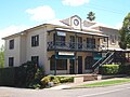
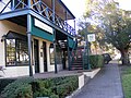
Commercial area
Hunters Hill has several commercial areas. A small group of shops is located on the corner of Alexandra and Ferry Street, with others scattered along these streets and Woolwich Road. A busier commercial area is located around the intersection of Ryde Road and Gladesville Road, near Burns Bay Road.
Schools

Hunters Hill is the site of the AAGPS Catholic boys' secondary school, St Joseph's College. It is also home to Hunters Hill High School, Boronia Park Public School, Hunters Hill Primary School and Villa Maria Primary School.
Clubs
Hunters Hill Rugby Union Football Club established in 1892 competes in the New South Wales Suburban Rugby Union has won the Kentwell Cup 8 times and 1st Division club champoinship 5 times. The second most distiguished club in Subbies, recently won the Stockdale Cup and Robertson Cup in 2010. The Robertson Cup was named after former Suburban Chairman (1978-80), Brian Robertson, this cup was first won by Port Hacking. After not being contested between 1988-93, the Robertson Cup was revived to become the Colts trophy for second division. The Farrant Cup was named after life member Don Farrant, a long time supporter of sub-district rugby, Hunters Hill club stalwart Don Farrant presented the Farrant Cup to the MSDRU in 1974. Initially included in an expanded fourth division, it became the award for the Division Three second grade premiership in 1995. Hunters Hill Rugby Union Football Club is a club that caters for all ages and level of ability and play matches at Boronia Park from March thru to August.
Landmarks
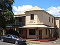
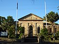
There is a private hospital in Alexandra Street and in High Street, a Jewish nursing home and synagogue named the Sir Moses Montefiore Home. The historic Hunters Hill Town Hall is located in Alexandra Street, close to the historic post office.[10]
The Great North Walk, a walking trail from Sydney to Newcastle,[11] passes through Boronia Park; a large waterfront parkland reserve which contains Aboriginal drawings thought to date back to before the start of the colony.
Heritage
The following buildings are listed on the Register of the National Estate.[12]
- Public School including Eulbertie, Alexandra Street
- Post Office, Alexandra Street
- Town Hall, Alexandra Street
- St Ives, Crescent Street
- Anglican Church of All Saints, corner Ferry and Ambrose Streets
- Kyarra, Madeline Street
- Fig Tree House, Reiby Road
- Clifton, Woolwich Road
- Waiwera, Woolwich Road
- St Claire, Wybalena Road
- The Chalet, Yerton Avenue
- Woolwich Dock, Franki Avenue, Woolwich
- Former Garibaldi Inn, Alexandra Street
Houses
Hunters Hill has an area of 5.75 square kilometres including some 650,000 square metres of parks and reserves. Developments are mostly residential.
Hunters Hill has a number of heritage-listed buildings and is positioned near the confluence of the Lane Cove and Parramatta Rivers, as well as the headwaters of Sydney Harbour, which provides river and harbour views. Previously having a number of residents of French extraction, it was known as the "French Village"[13] and shares a friendship with a sister city near Paris, Le Vésinet.[14]
Notable residents
- Henry Budden, architect
- Cate Blanchett, actress
- Andrew Upton, writer and spouse of Cate Blanchett
- Kyle Sandilands, radio and tv host
- Ann Sanders, newsreader
Gallery
This section contains an unencyclopedic or excessive gallery of images. |
-
 Former Garibaldi Inn, corner of Alexandra and Ferry Street
 -
 Ferry Street
 -
 Local shops in Hunters Hill
 -
 Alexandra Street
 -
 Hunters Hill Post office
 -
 St Peter Chanel Catholic Church
 -
 Community (Congregational) Church
 -
 Church of the Holy Name of Mary
 -
 St Josephs College
 -
 Vienna, a restored sandstone worker's cottage
 -
 Alroy
Alroy -
 Former post office
 -
 Fig Tree House as viewed from the opposite shore of the Lane Cove River
 -
 Town Hall
 -
 War Memorial beside Town Hall
 -
 Masonic Temple


References
- ^ a b c Australian Bureau of Statistics (25 October 2007). "Hunters Hill (State Suburb)". 2006 Census QuickStats. Retrieved 2007-12-21.
- ^ Point 2 Point Accessed 3/7/2009
- ^ The Book of Sydney Suburbs, Frances Pollon, Angus & Robertson Publishers, 1990, p.126, ISBN 0-207-14495-8, page 127
- ^ Gladesville Bridge Accessed 3/7/2009
- ^ "State Electoral District - Lane Cove Results 2007". State Elections. Electoral Commission NSW. 2007. Retrieved 2007-12-28. Percentages calculated using combined results for "Hunter's Hill" polling booths, and only counting formal votes.
- ^ "Polling Place - Hunter's Hill". House of Representatives - Election 2007. Australian Electoral Commission. 2007. Retrieved 2007-12-28.
- ^ "Electoral Division of North Sydney (NSW) The Hon Joe Hockey MP". Members. Commonwealth of Australia. 2008-03-14. Retrieved 2008-03-16.
- ^ "Mr Anthony John ROBERTS, MP". Legislative Assembly. Parliament of New South Wales. 2007. Retrieved 2007-12-19.
- ^ a b "Hunters Hill Transport". Accessed 8/7/09
- ^ Hunters Hill, NSW Australia Accessed 3/7/2009
- ^ Sydney and Blue Mountains Bushwalks, Neil Paton, Kangaroo Press, 2004
- ^ The Heritage of Australia, Macmillan Company, 1981, p.2/30
- ^ Hunters Hill Historical Society Museum
- ^ Discover Hunters Hill Accessed 3/7/2009
- The Official Community Profile of Hunters Hill
External links
- The Official Community Profile of Hunter's Hill
- Hunter's Hill Municipality website
- 2001 Census Information
Template:Mapit-AUS-suburbscale
DiscoverHuntersHill http://www.huntershill.com.au