
Talk:Armenia: Difference between revisions
attribution |
→Roman temple at Garni: new section |
||
| Line 271: | Line 271: | ||
: I noticed this the other day. I know it was the least of your concerns but I changed the heading layout to a more logical one used by many other nation articles. However the Municipalities in Armenia template seems to be broken and overlaps the text below it. Can anyone fix this? --[[User:Iae|Iae]] ([[User talk:Iae|talk]]) 17:31, 26 April 2011 (UTC) |
: I noticed this the other day. I know it was the least of your concerns but I changed the heading layout to a more logical one used by many other nation articles. However the Municipalities in Armenia template seems to be broken and overlaps the text below it. Can anyone fix this? --[[User:Iae|Iae]] ([[User talk:Iae|talk]]) 17:31, 26 April 2011 (UTC) |
||
== Roman temple at Garni == |
|||
As I know the temple at Garni is Armenian. It can be considered Hellenistic(from architectural point of view), but not Roman in any case. |
|||
Revision as of 05:30, 13 May 2011
| This is the talk page for discussing improvements to the Armenia article. This is not a forum for general discussion of the article's subject. |
Article policies
|
| Find sources: Google (books · news · scholar · free images · WP refs) · FENS · JSTOR · TWL |
| Archives: 1, 2, 3, 4, 5, 6, 7, 8, 9Auto-archiving period: 90 days |
Template:Outline of knowledge coverage
| This article is of interest to the following WikiProjects: | |||||||||||||||||||||||||||||||||||||||||||||||||||||||||
| |||||||||||||||||||||||||||||||||||||||||||||||||||||||||


 | This article and its editors are subject to Wikipedia general sanctions. |
| A fact from this article was featured on Wikipedia's Main Page in the On this day section on 13 dates. [show] |
|
|||||||||
|
This page has archives. Sections older than 90 days may be automatically archived by Lowercase sigmabot III when more than 5 sections are present. |
| This is the talk page for discussing improvements to the Armenia article. This is not a forum for general discussion of the article's subject. |
Article policies
|
| Find sources: Google (books · news · scholar · free images · WP refs) · FENS · JSTOR · TWL |
| Archives: 1, 2, 3, 4, 5, 6, 7, 8, 9Auto-archiving period: 90 days |
| Text and/or other creative content from Armenian Soviet Socialist Republic was copied or moved into Armenia with this edit on 18:01, 14 November 2010. The former page's history now serves to provide attribution for that content in the latter page, and it must not be deleted as long as the latter page exists. |
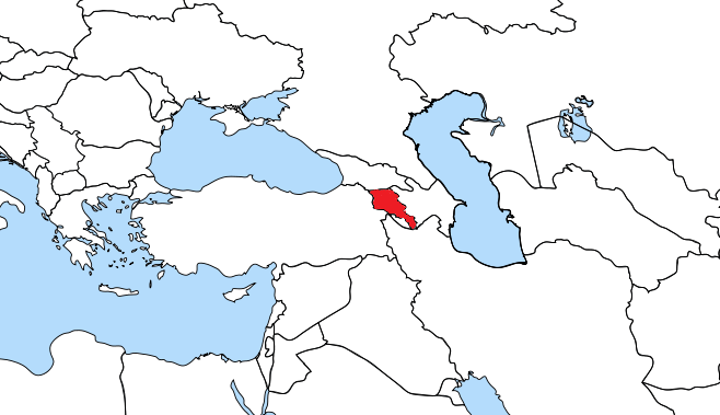
Map of Armenia
Okay, can we stop constantly changing the map? The reason I put forth my map, because it shows Armenia in context of Europe, which is very appropriate as Armenia is politically Europe (Council of Europe, EU Partnership, etc) - plus the added initiative of Armenia's integration with EU. The orthographic map is to zoomed out also. Check the maps for Georgia and Azerbaijan, similar sized Caucasian states and you will see the same type of map also.
MosMusy (talk) 01:46, 7 January 2011 (UTC)
- This map doesn't show Armenia in the context of Europe. Even if you used this style: File:EU-France.svg, it wouldn't show Armenia in the context of Europe, it would show it outside Europe, because the truth is that Armenia is not in the context of Europe right now. I also don't understand how showing a map of Armenia "in the context of Europe" on Wikipedia will help Armenia's politics. If anything, this map looks like Armenian users on Wikipedia don't care enough to upgrade the map of Armenia to the same standard as other more advanced countries (like, Europe, USA, Russia, Turkey, etc.). The orthographic projection is the standard map on Wikipedia for any country (see Dominican Republic for your "zoomed out" arugment), including Europe. Armenia is not a state of Europe, therefore, it is useless to pretend it is (like Azerbaijan is trying). It only makes the article on Armenia look behind other countries' article.Kentronhayastan (talk) 23:50, 7 January 2011 (UTC)
No, Armenia is politically Europe, that is fact. It's not trying to pretend, it is politically part of Europe and is moving towards EU. You can't argue against this. Both Georgia and Azerbaijan which are considered politically Europe like Armenia have such maps, and so should Armenia. If this particular map doesn't suit you, fine, but there must be a map that shows Armenia in context of Europe just like for the other Caucasian states, and yes were are not in the middle of Europe so obviously the map will not be perfectly centered.MosMusy (talk) 05:50, 8 January 2011 (UTC)
- No, Armenia is not in the European continent, nor is it part of the European Union. It doesn't even have a strip of land in the continent of Europe (Georgia and Azerbaijan do). Turkey and Israel are also considered politically Europe (in fact, Turkey has Thrace in Europe), but their maps don't represent their country in the sphere of Europe. The Turkish government has shown a realistic interest in joining the EU, while the government of Armenia made it clear that Armenia has no intentions of joining the EU, so it is not moving toward EU. It does however have good diplomatic relations with it, which it plans on improving. This doesn't mean we have to jump to conclusions and include Armenia in the sphere of Europe. Armenia is in the Russian sphere (it is a member of the CIS), not the EU. Finally, not all Armenians agree that the EU is the best option for Armenia, so please don't impose your political position on the article. The orthographic projection is a standard on Wikipedia. It is a politically neutral map. Therefore, it is the right choice. (For the record, I do agree EU is the right direction for Armenia, but this is not a fact right now. Armenia is far closer to Russia (and Russian organizations) to be anywhere near an EU integration). Kentronhayastan (talk) 23:37, 9 January 2011 (UTC)
No, you are confusing political organizations with strategic alliances. Armenia is strategically (militarily) aligned with Russia (CIS), however, politically it is reforming by EU standards and by the careful advise of EU. This is all part of Armenia's membership in Council of Europe and it's role in EU's Eastern Partnership. I can show you several speeches by the President and Foreign Minister that clearly show Armenia's intentions to integrate with Europe and the opinion that Armenia is an European country. No one is talking about EU membership yet because it's way to soon, however Armenia will become associate member very soon and that is a step on a very long journey to such membership. Armenia's political contacts with EU are intense and every few weeks there are meetings. Even Russia is edging closer to EU. Again, Armenia political alignment with EU is fact not opinion, yes it has strategic relations with Russia but that's different from political relations. Is Armenia adopting Russian laws? Is it integrating its structures to meet Russian standards? No. It is being done with Europe. The map is very important and it fails to show this clear fact of Armenia's political alignment. MosMusy (talk) 06:27, 10 January 2011 (UTC)
- First of all, you can't barge in on an article about a country, and replace an image which follows the standards of Wikipedia and that was used and accepted for almost a year. Please come to an understanding with other users before making such changes.
- Once again, whatever you said applies more to Israel and Turkey than Armenia, yet none of them have a map that includes their country in the territorial sphere of Europe. In fact, Turkey should have such a map, because it has part of its territory in Europe, and has concrete, official, recognized interests in becoming an EU member. Armenia has none of this, and it doesn't have an inch of land in Europe. Strengthening strategic political ties with Europe is not a reason to be considered in the territorial sphere of Europe. It is territorially in Asia, South-West Asia to be precise, as recognized by the UN. Besides, changing the map this way makes no difference for the politics of Armenia. Your map won't help Armenia become an EU member in any way, and once again, not all Armenians agree with EU integration. You can't impose your political views in the name of all Armenians. The orthographic projection map is neutral, and it is a standard for all countries on Wikipedia (including the EU). This is final. This discussion won't go any further, repeating will be inevitable, therefore invite a third person to review our arguments, and see which of us makes the most objective choices. Until then, don't change a map that follows the standards of Wikipedia and that was accepted and used for almost a year. My discussion ends here. Any more edits will result in an edit war.Kentronhayastan (talk) 17:16, 12 January 2011 (UTC)
My image follows Wikipedia standards, I actually got it from the Wikipedia archive of maps of Armenia. Second, I am not imposing my political beliefs here; please read carefully. Armenian Government has stated numerous times, the president, foreign minister, etc. that European integration is a foreign policy priority, and that Armenia's future lies with EU. Armenia's political leanings are clear. Yes strategic relations are with Russia but again strategic is different from political, EU is not a strategic entity (NATO is). And Israel is not a member of Council of Europe while Armenia is; Council of Europe has been very influential on the reforms and laws that have been happening in Armenia. A political map must show a country's political leanings, for Armenian and the Caucasian countries that political entity is EU. I do not believe your map is valid for a political one, and am willing to further this issue until it is properly resolved.
And actually most Armenian support EU membership, and have positive view on EU. But this is still not important as the populace is not making the political decisions but the government. The opinion of the Armenian public is irrelevant here.
MosMusy (talk) 02:50, 13 January 2011 (UTC)
- As I said, I can only repeat. Turkey is in a much more appropriate position to have a map in the territorial sphere of Europe: 1. It has a large chunk of land in Europe (Thrace), 2. It has realistic aspirations to become a full member. Yet, it has an orthographic projection as a map instead because 1. It's the standard on Wikipedia for country maps, except for those countries that are part of the EU, or have land in EU, (and even then, there are exceptions: see Romania). Armenia does not have territory in Europe, nor is it anywhere near becoming a full member. The orthographic projection is a standard on Wikipedia, and it is neutral (yes, there are Armenians who disagree with EU integration). So far, you have failed to prove that most Wikipedia users would agree with you, since you're the only one defending your view. The orthographic projection is accepted by everyone thus far, and not a single complaint was brought up (except by you). We are not obliged to follow your view. Unless you prove that other Wikipedia users will agree with you, I will continue to undo your edits. Otherwise, I will gladly make an svg map of Armenia in the territorial sphere of Europe, following the standards of Wikipedia for maps. Final words: Do not start an edit war until you have proven to me, through other users, that the map must be changed to include Armenia in the territorial sphere of Europe.Kentronhayastan (talk) 17:46, 27 January 2011 (UTC)
You must understand that this is a political map (not Geographic!). A political map shows with what part of the world the country in question belongs to, with what part of the world it identifies with politically. For Armenia, that region is Europe, and that is fact, government and foreign minister numerous times has said that Armenia's foreign policy priority is European integration. There's nothing to argue here, Armenia is politically Europe, end of story. It doesn't matter what the public thinks, it matters what the government's policies are, and politically it is pro-EU. Don't compare Armenia to countries like Turkey or Romania, compare it to similarly sized and located countries next to us which use a pro Europe map, as they similarly are striving European integration, especially Georgia. Why should Armenia be any different? The political leaning of the Caucasus is towards Europe, and it has always been like that. I will not rest until this is properly resolved, and will do anything for a truthful map to be put up that represents my country. I can gather allies, but I don't want to turn this rather small issue into a huge edit war. And again my image is from the wiki database of maps of Armenia. MosMusy (talk) 21:03, 27 January 2011 (UTC)
- MosMosy's map has my vote.-- Ευπάτωρ Talk!! 02:43, 1 February 2011 (UTC)
- Kentronhayastan's map is the logical one. My vote is on his map.--Cerian (talk) 12:47, 1 February 2011 (UTC)
- That's nice of you, care to elaborate why? If this revert warring continues I'm gonna request page protection. I suggest Kentronhayastan creates an RFC if he wishes to continue this debate without edit warring. I'm reverting back to the original map that had a wide concensus for a very long time, along with the Georgian version.-- Ευπάτωρ Talk!! 16:55, 1 February 2011 (UTC)
- It's not right of Caucasus countries to portray themselves as part of Europe even if they are an Euro-Asian country. Just because you're politically leaned to Europe doesn't mean you have to portray your country in Europe's continental shelf. If you become an EU member that's a different story, but until then...--Cerian (talk) 18:57, 1 February 2011 (UTC)
- That's nice of you, care to elaborate why? If this revert warring continues I'm gonna request page protection. I suggest Kentronhayastan creates an RFC if he wishes to continue this debate without edit warring. I'm reverting back to the original map that had a wide concensus for a very long time, along with the Georgian version.-- Ευπάτωρ Talk!! 16:55, 1 February 2011 (UTC)
- Kentronhayastan's map is the logical one. My vote is on his map.--Cerian (talk) 12:47, 1 February 2011 (UTC)
- Neither map shows the whole world, right? One shows it in the hemisphere, the other closer in. Since Armenia is so tiny, and is part of (in my mind) Europe and/or the Middle East, it should be presented on such a map. Also, quite a few small countries are given closer in, Djibouti for example. Abductive (reasoning) 19:51, 1 February 2011 (UTC)
- "I suggest Kentronhayastan creates an RFC if he wishes to continue this debate without edit warring. I'm reverting back to the original map that had a wide concensus for a very long time," Eupator, I suggest you check the history of this article. For almost a year, it was the orthographic projection that was the original map that has a wide consensus for a very long time. MosMosy must create an RFC if he wishes to continue editing this article to his desire, not me.
- And about Armenia being tiny, if you look at Dominican Republic, it is also a tiny country, yet they have an orthographic projection, with a zoomed layer, just like the map of the orthographic projection I am using for Armenia. Also, https://www.cia.gov/library/publications/the-world-factbook/geos/am.html Kentronhayastan (talk) 20:03, 10 February 2011 (UTC)
Armenia is a South Caucasian country. All the South Caucasian countries are politically Europe (Georgia, Azerbaijan) as they are full members of Council of Europe and all governments express their priority in integration with EU structures. That is fact. The map that is shown is a political map, not Geographic!! That is key to understand, we here show a political map, and thus must show Armenia in context of Europe. In addition to that, all the maps for the two other South Caucasian countries show their countries in context of Europe, why should Armenia be any different? It's in the same political context as those two other countries thus it deserves the same political map. MosMusy (talk) 20:24, 1 February 2011 (UTC)
- I can return that Argument by stating that Turkey uses an orthographic projection for its article, and unlike Armenia, it actually has territory in Europe, and unlike the rest of the Caucasus states, it actually has realistic aspirations of becoming a full member of the EU.
- In addition, I'd like to add that all other language Wikipedias use the Orthographic projection, so there is no debate whether this map was accepted my the majority for a long time.Kentronhayastan (talk) 20:07, 10 February 2011 (UTC)
- You absolutely cannot. Do not compare Armenia with Turkey, for the last time! You have to compare Armenia with its South Causasian neighbours (Azerbaijan and Georgia) all of them have maps that contain them in Europe, and so should Armenia. I don't care how long ago it was "accepted" people make mistakes, and many people don't understand the purpose of maps very well. I really have to repeat this everytime, and it falls on deaf ears. This is a political map! Not geographic! A political map shows with what political body that country is with. For Armenia and all the South Caucasus countries that is Europe. Why should Azerbaijan and Georgia have politically Europe maps and not Armenia? Answer me that question. I will put all the power I have to fight this, because it is truly disgusting that we have people here trying to twist facts and portray something Armenia is not. This map is very important for many people, and I suggest you do not ruin this good page on Armenia with an inaccurate map. I will use your map, so we're on the same page. MosMusy (talk) 22:20, 10 February 2011 (UTC)
- By the way, if we all decide to include Armenia within the territorial/political sphere of Europe, I have uploaded a map that follows the standards of Wikipedia ala non-EU European states (Serbia, Albania, etc.). Here it is: commons:File:Europe-Armenia.svg Kentronhayastan (talk) 20:22, 10 February 2011 (UTC)
- I believe my map (which I got from wikimedia source of Armenian maps and follows wikipedia guidelines) is better, as it shows armenia more clearly.MosMusy (talk) 23:29, 10 February 2011 (UTC)
It seems clear from the lead of this article that Armenia is best considered a European state, rather than an Asian. In any case, the Europe map shows Armenia more clearly than the world map, obviously. Therefore I would prefer the Europe map here, agreeing in this with User:MosMusy. I would like to stress that the reverts here have to stop, or some editors will find themselves blocked. Debresser (talk) 00:42, 11 February 2011 (UTC)
- Thank you. Though I propose this map, as it shows Armenia more clearly: File:795px-Europe map armenia.png but that can be put up to a vote, the important thing is the map shows Armenia in a European context.MosMusy (talk) 01:54, 11 February 2011 (UTC)
- How about this map? File:LocationArmenia.svg It shows context and Armenia is bigger :). The one you propose has better contrast, though. --Diannaa (Talk) 02:25, 11 February 2011 (UTC)
- Are you joking? We have already agreed for Armenia to be displayed in context of Europe, that map is horrible. The choice is between: File:795px-Europe map armenia.png and File:Europe-Armenia.svg. MosMusy (talk) 02:27, 11 February 2011 (UTC)
- All right, since we have all come to a consensus, let's use the Europe map. However, I'd like to warn the users here to read through the argument before accusing others of edit warring. The original map was the orthographic projection, in use for almost a year, and MosMusy changed it for the Europe map without a discussion, and I told him to discuss before changing, and returned it to the original. Yet he continuously changed it back to his map until he finally began to discuss. However, even during the discussion, he continuously changed the map without coming to a consensus. I don't understand how I became the "edit warrer" when I was simply defending the original map that is accepted and used throughout all language Wikipedia articles of Armenia, and he tried to impose his map without a mutual understanding with third person support. Kentronhayastan (talk) 16:01, 1 March 2011 (UTC)
- It takes two to edit war. That is why both of you were warned. Not nice, shaking your fist after the fight is over. Debresser (talk) 16:20, 1 March 2011 (UTC)
- You're right, I thought it was only aimed at me, but I see you have also warned MosMusy. I apologize for my recklessness. However, I still consider it unfair to risk myself getting blocked because a user was trying to impose his change without a universal consensus. I told him to not edit the original article until the debate is over, but he continued to revert without a consensus. I wasn't against his view, but I know there is an opposing view, and since Wikipedia should be neutral, I took the side of the opposing view in order to get justification for the change. The orthographic projection is not a "false representation" as it shows Armenia in the context of the world, rather than limit it to Europe. And for the recored, these maps are both political and geographic (do I really have to specify this?), and although Armenia is politically European, it is geographically Asian. A discussion requiring more than a one-on-one debate was required. So far, I have seen that most users prefer the European map, therefore, I will accept it as such until/if the debate is revived. Kentronhayastan (talk) 16:03, 2 March 2011 (UTC)
- I was merely making a change to a blatant mistake. Why does that constitute as an edit war? Please tell me this. So on Wikipedia if you change something to the right thing, you get punished for that? That is truly ridiculous. Again, it's not your choice to make if the map on the main page of a country map is political or geographical - it's political, all country's main maps are, unless you've seen a country page with a geographic map, which you haven't. Given that it's political, and Armenia is politically Europe (which is again factually widely understood), then it should be a no brainier that the map should be in a European context, but instead of looking at this logical procession and accepting my correct changes, Kentronhayastan proceeded to begin an edit war, putting the false map over and over. And with that I am ridiculously warned for trying to prevent false information - please provide a substantial rationale for that please, as I will appeal this warning as it makes no sense at all to punish me. Second, as I have said numerous times the maps of the 3 South Caucasian nations need to follow the same format as we are all geographically and politically in the same group. Given, both Georgia and Azerbaijan used pro-Europe map, this is yet another justification for this. It's not about preference, it's about what is factually correct and that is the Europe map. I hope this ridiculous event will not repeat again and there will be more sanity here. MosMusy (talk) 01:15, 3 March 2011 (UTC)
look, for years there have been attempts to show that "some sources place Armenia in Europe". Some people apparently wish to maintain this out of pure personal preference, never mind reality. They have even gone as far as citing the Oxford Reference page on Georgia to claim this source places Armenia in Europe. While, of course, it places Georgia in Europe and Armenia in SW Asia. This thing has been tagged with {{verify credibility}} since 2009.
Nobody has bothered to adduce any actual references other than worldatlas.com; worldatlas.com is not a quotable source. It is a commercial website trying to make some dollars by feeding online ads to people googling for maps.
I grant you that worldatlas.com states that "Historically Armenia and Azerbaijan have been long associated with Asia and the Middle East. In recent years some sources now consider them to be more closely aligned with Europe based on their modern economic and political trends." They do not name these "sources". Presumably they mean Wikipedia. I.e. the people trying to claim there are sources claiming what they want are actually citing themselves. Nor do they explain how "modern trends" make a country part of Europe. Since China and India are now industrialized, an idea they clearly adopted from Europeans, presumably these are now also considered European countries by "some sources"? And conversely, failed economies like Greece or Portugal are now presumably part of Asia? The bottom line being that "Europe" really means "good" or "successful" and "Asia" means "bad" or "backward"? I am sure that most Asians will be thrilled to hear about this interesting proposition.
This is just dodgy. Not worthy of an encyclopedia.
On the encyclopedic side, we have the UN, the CIA Factbook and Oxford Reference Online all unambiguously placing Armenia in Asia. So, it's worldatlas.com vs the UN, the CIA and Oxford. I'll leave it as an exercise to do the WP:DUE appreciation of this.
--dab (𒁳) 09:49, 1 April 2011 (UTC)
DO NOT CHANG THE MAP AGAIN!! It has been already decided upon after much discussion what map will be used, read through that discussion and you will see. Any further changes will be reported and you will be disciplined. MosMusy (talk) 13:02, 1 April 2011 (UTC)

address to the issue please. I have raised this back in 2009. The thing has been tagged for two years. One "reference" turned out to be fraudulent. We have rules around here, and they revolve around your ability to support a point using WP:RS, not who can be the most annoying pov pusher. I have just reviewed the references we have. Clearly, Armenia is a country in SW Asia. Locator maps show the location of a country within its wider region, not relative to some other continent. Are we showing Poland in a corner of a map of Asia? No. Are we showing Cuba in a corner of a map of South America? No. Are we showing Japan relative to North America? No. Because that would be extremely stupid: a locator map with the thing it is supposed to "locate" stashed away in a corner is stupid. The region of Armenia is the Caucasus, or arguably including the wider Armenian Highlands of Asia Minor, not Iceland. --dab (𒁳) 10:50, 2 April 2011 (UTC)
Apparently you don't know much about maps. This is a political map - Armenia political is part of Europe along with the rest of the South Caucasus. This is a fact. Armenia is not part of the politics of Middle East and thus it's inaccurate to place Armenia with that part of the world. Armenia has to be placed within context of Europe like Georgia and Azerbaijan, the two other South Caucasian countries. We have discussed this at nausea and it was agreed that Armenia will be put with Europe map - and now you come here and begin to changing everything. You keep this up, I will report you as Moderators are looking out for people who keeping changing the map. I don't take this lightly a person putting false information about my country. MosMusy (talk) 16:49, 2 April 2011 (UTC)
- Dear Sir, I do not know what "moderators" you are talking about, but I would likely be one of them, and the last time I heard, the administrative corps - and particularly myself - had an extremely low tolerance for nationalist revert-warriors. Maps are maps. The last time I heard, they are geographic tools, not political ones, and it makes zero sense for the article itself to state "Armenia is part of Southeast Asia", and then for the map to show it as part of Europe. If you actually come up with some reliable sources that place Armenia inside Europe, I will be thrilled. Until then, kindly stop revert-warring and trying to bully Dbachmann like you managed to bully others above; the alternative is to get page-banned under WP:ARBAA2. Thank you. Moreschi (talk) 22:11, 2 April 2011 (UTC)
- Moreschi, please explain why the Georgia and Azerbaijan pages have a map which shows them as part of Europe, when they too are located in southwest Asia.--Moosh88 (talk) 03:05, 3 April 2011 (UTC)
- There are political maps and there are Geographical maps. This is a political map meant to show in what political context the country belongs in. For Armenia that is Europe along with the other South Caucasus countries that have their political ties with Europe not Middle East. It's just so absurd to place Armeia as part of Souteast Asia, but then put its other neighbours as part of Europe. No that's not how it works. We had a lenghty discussion concerning this I suggest you take a look at it rather than barging in with misinformation. As I have said before, I will not rest when misinformation is being placed about the political context of my country. The South Caucasus is a seperate region from the Middle East - I suggest you read up on this. MosMusy (talk) 03:40, 3 April 2011 (UTC)
- Well, European Union considers Armenia as an European country. Here is a link from their official website http://europa.eu/abc/european_countries/others/armenia/index_en.htm So some wikipedia users know Europe better then the European Union ? — Preceding unsigned comment added by Ali55te (talk • contribs) 03:43, 3 April 2011 (UTC)
- Do not change the map, without proper justification! This is a political map. It's meant to show in what political context the country is. For Armenia that is Europe. That is fact. There's no more you can say. And if your were true with your intentions you would be pushing the same agenda for the other Caucasian countries, but apparently this is just a campaign against Armenia. MosMusy (talk) 17:04, 3 April 2011 (UTC)
- MosMusy, your continued unprofessional tone and your repeated reverts, without sufficient sources, to the appropriate SW Asia map that has long been appropriately associated with this article are inappropriate. Two experienced, well-regarded administrators and editors above (Moreschi and --dab are 100% correct both in their comments regarding WP procedures (no, repeating enough times that you "had a consensus" does not make it so) and their comments on the content.
- I've noticed you use the term "political" 65 times in your arguments here and on other pages. Unfortunately (for your fallacious argument), as Moreschi points out above, maps, even so-called "political maps", are primarily tools of geography, not politics. Continental definition relies on various factors, primarily geographic; thus for decades if not centuries, in publications by the most-respected geographic authorities ( dab cites several above and neglects to mention the National Geographic Society in the US which also places Armenia in Asia), despite some religious and political ties to Europe, Armenia has and will be considered to be in SW Asia, not Europe. This is partly because major mountain ranges have, for eons, separated peoples and states in a fashion second-only to large water bodies; thus the Black Sea-Caucasus Mtn.-Caspian Sea division between continents.
- As a professional geographer for 30 years, I've authored or co-authored the relevant portions (continental definitions) in one or two of the published sources cited above and can assure you that (not all) but most relevant authorities view "continental assignment" to be guided primariy by geographic factors, including physical geography, not purely political or religious or cultural. Otherwise, we would have Israel in Europe. We need to stick with the real consensus of worldwide geographic authorities, not a contrived WP "consensus" of you and a few others who happened to be looking in a couple months back, and leave the SW Asia map for Armenia.DLinth (talk) 17:49, 4 April 2011 (UTC)
This is the thing. The map is not a purely geographical one, it is supposed to show in what context of the world that country belongs. To what part of the world the country is influenced and involved politically. For, Armenia this is Europe. DB was questioning that Armenia is not politically Europe, below I have several sources proving this. The biggest one is that Armenia is part of Council of Europe (Israel is not and is not considered a European country by the EU or EU political structures - as you see there is a difference). European Union classifies Armenia has European country - they have higher credibility in doing so than anybody here. And of course, I have several examples showing that Armenian Government is integrating with EU. Armenia in no doubt deserve a European context not a Middle East context when it comes to show it on the map. Geographically, Armenia is part of the South Caucasus, a different entity from the Middle East, you should know this. This brings me to my second point. I really don’t understand the double standard that is being used here. So Georgia and Azerbaijan can have maps showing them in clear European context (Azerbaijan is almost not showing in its map) while Armenia has to be shown in SW Asian context, because its neighbours are soo much closer to Europe and so much more European?. It’s truly ridiculous and comes to show the real intentions in making these map edits here. If you were really genuine in your map changes you would have made it to the rest of the South Caucasus which falls in the same geographical locations and all countries in South Caucasus are politically Europe like Armenia. Confirmed again by official EU and Council of Europe which made this decision very long time ago and have higher legitimacy in this matter than anybody here. I will not rest until this issue is resolved in a proper manner that shows no double standards.
If no proper response in a timely manner, I will revert the edit, as I have fully spelled out here my justifications.
http://europa.eu/abc/european_countries/others/index_en.htm
http://www.panarmenian.net/eng/politics/news/24261/
http://www.armradio.am/news/?part=pol&id=18723
http://www.gov.am/en/news/item/5418/
http://www.armenianatomission.com/index.php?cnt=4&sub=12
http://www.yerevanreport.com/5012/armenia-step-up-european-integration/
http://news.am/eng/news/22489.html
http://enpi-info.eu/maineast.php?id=24541&id_type=1&lang_id=450
http://www.aysor.am/en/news/2011/03/25/eu-armenia/
http://www.hurriyetdailynews.com/n.php?n=armenia8217s-european-perpectives-2010-09-23
Armenian Government Foreign Policy:
One of Armenia’s foreign policy priorities is gradual integration into European architecture. Armenia’s European aspirations are based on the nation"s historical and cultural affiliation. Having European civilization background and being committed to shared values enshrined in the European Unions (EU) fundamental treaties Armenia established good partnership with the EU. Respect of democratic principles, the rule of law and human rights are the core values on which Armenia-EU relations are based.
There is an intensive cooperation between Armenia and the EU in various fields, ranging from trade and economy to science and education. During last years EU proved to be a partner aimed at helping Armenia’s transition to a market economy and stable democracy. The Armenian Government coordinates its cooperation with external help and, together with the EU, focuses its efforts on such important problems as fighting corruption, the reduction of poverty and inequality, stable economic growth, particularly through international trade. The EU remains Armenia’s number one trade partner and one of the biggest foreign investor in Armenia. EU helps Armenia to implement the next generation of reforms aimed at further strengthening of democratic institutions and respect of human rights. The Armenian Government’s objective is also approximation of Armenia’s legislation to that of the EU and in this regard the cooperation is there.
Armenia-EU political dialogue comprises wide range of bilateral and international issues. Parties are determined to increase diplomatic efforts, including through the EU Special representative for the South Caucasus, and to continue to support a peaceful solution of the Nagorno Karabakh conflict. Since June 2007 Armenia was invited to align itself with CFSP declarations on a case-by-case basis. It has done so on most opportunities.
Mission of the Republic of Armenia to the European Communities established in 1994 represents the Republic of Armenia in all the EU institutions and structures. Its main task is to advance Armenia’s European integration.
It has been over ten years that the Delegation of the European Commission for Georgia and Armenia first started to carry out its activities in Tbilisi. On 1 November 1999 an office in Yerevan, Armenia, was opened to expand the Commission"s activities in the region. Yerevan office of EC Delegation was upgraded into full-fledged delegation in 2005. Inauguration of full-fledged EC Delegation and opening of new premises of the Delegation took place in February 2008. Ambassador Raul de Luzenberger was appointed head of EC Delegation.
In 2003, with the appointment of the EU special representative for the South Caucasus, the EU committed to a more practical involvement in the region and provided a permanent mechanism of contact of both bilateral and regional nature. Mr. Peter SEMNEBY is EU Special Representative for the South Caucasus
MosMusy (talk) 23:11, 4 April 2011 (UTC)
Nobody disputes there is "Armenia-EU political dialogue". What is your point? There is also US-EU political dialogue, Japan-EU political dialogue and Egyptian-EU political dialogue. Also, why are you listing random urls as "references"? Have you read WP:RS? Then why do you refuse to cite proper references to support your opinions? You seem to be interested in the foreign relations of Armenia. This is certainly an encyclopedic topic, and as soon as you get a basic grasp of how to cite references, you may consider editing Foreign relations of Armenia, an article in dire need of attention. Thank you. --dab (𒁳) 09:32, 5 April 2011 (UTC)
- Apparently you didn't get the point of my post. It's not just Armenia-EU dialog, the EU considers Armenia a European country. It doesn't consider Israel, USA or Japan as European. That is why Armenia is part of Council of Europe, but Israel, US or Japan are not. There is a key difference here you apparently fail to grasp. Armenia does not belong in the same category of countries like US or Japan, because it's already considered part of Europe. European Union has the ultimate power in deciding this, not you, me, or anybody in here. The references I put and not some random links but attest to this fact. The first one shows the official EU website, listing the European countries. Other articles point to the fact that Armenia is integrating with EU and will be come associate member soon. And finally the text is from Armenia's foreign policy statement. You also failed to answer me why you have used double standards in pursuing a map change for Armenia, but not its neighbours, Georgia and Azerbaijan, who are similarly located. MosMusy (talk) 15:45, 5 April 2011 (UTC)
- It's disappointing to see, MosMusy, that despite the patient explanations from a considerable number of veteran editors, that you continue to cling to your unsubtantiated views that you are right, they are wrong, and the vast majority of relevant geographic authorities are somehow wrong as well. You claim that a continental designation (Europe or Asia) is somehow exclusively determined by 1990's-2000's political dialog, with "ultimate power" held by the EU to determine what continent a country falls in! That's silly. dab is quite correct above.
- Additionally, you claim that Country A (Armenia), after centuries of its history and geography being irrevocably linked with SW Asia (including the Asian part of Turkey, though not in a pleasant manner), sometime in the 1990's (based on your links and your argument) "jumped over" into Europe. And thus, Country B and Country C and Country D, when given EU membership, will do the same. Sorry, countries don't "jump around" from continent to continent with the political winds or dialogue of the moment. For centuries, Armenia has been considered an Asian state and will remain so. (The US has had ASEAN membership; the US is now a SE Asian nation?)
- Sorry, but the long prevailing view by authoritative published sources such as the World Factbook, National Geographic publications including their current atlas (both on its maps and in its list of countries), the UN, Oxford Reference online and thus WP is that Armenia is a SW Asian state, and the map in the article needs to not contradict the article by placing it in Europe.
- Regarding your last question above, both Georgia (a small portion) and Azerbaijan (a larger portion) have territory within Europe (the easily-most-widely accepted definition of "north of the Caucasus Mtns.".....placing Mt. Elbrus in Europe as its widely-recognized high point, by the way.)
- Politics, particularly recent politics, does not dictate a continental designation.DLinth (talk) 16:58, 5 April 2011 (UTC)
- Tell me if Armenia is so much linked with Southeast Asia, why does EU designate Armenia as a European country? While not designating Australia, US, or Israel? As I said, if you more informed about the region, you would know that the South Caucasus and Middle East are rather different entities in both geography and also culture (more so for Georgia and Armenia). As I have said the map is supposed to show the part of the world that the country is in context with and is associated with politically. A purely geographical map would should Armenia in a neutral position (with Armenia in dead centre), but the map you have put is neither an accurate political depiction of Armenia nor an accurate geographical map of Armenia. Lastly, I am going to try to see if I can understand this skewed logic. So, since Azerbaijan and Georgia have a tiny strip of land in "geographical" Europe they deserve a Europe context map, with the country being shown on the edge of the map, but Armenia which is right there deserves a whole other context? As a geographer you should see quickly the absurdity of this logic, and would know that South Caucasus deserves the same context in its map. Instead, these changes are being imposed only on Armenia, which show the double standards and unprofessionalism in the people pushing it. I will continue to revert the map change, until I get a proper response and justification, and it is clear to me no double standards are being used. I willing to discuss this but am not willing to submit to skewed logic. MosMusy (talk) 19:41, 5 April 2011 (UTC)
- Cyprus is also not geographically in Europe but it is shown in Europe context. So MosMusy has a good point here if you want to enforce a asian map on Armenia than you should do for every similar article.Ali55te (talk) 22:47, 5 April 2011 (UTC)
- Cyprus is an island, not on a continent and thus hardly relevant. "Eurasian island in the WP article. A Mideast regional map in my opinion would make the most sense....Others can discuss that. This topic is about non-island countries, Armenia in particular. MosMusy has been banned twice for nationalist revert-warring, threatening to "just revert" what he doesn't like, and for refusing to get the point. More above.DLinth (talk) 16:55, 6 April 2011 (UTC)
- I don't understand the logic here. Japan is an Island also. That means we can show Japan in any context we want ? — Preceding unsigned comment added by Ali55te (talk • contribs) 18:01, 6 April 2011 (UTC)
- No, not at all. Each state is a case by case basis. Japan, UK, Madagascar, Singapore tend to fall into the "no-brainer" category, so closely linked to one and only one continent. Some other island territories such as St. Helena are close to no continental land mass, and ones like Trinidad and Tobago open up another can of worms.
- A sensible discussion would require comparing only apples to apples, so Japan and the others above are quite different than Cyprus and, to my original point, Cyprus is (vastly) different than Armenia's case. There are no "rules" or logic that necessariy apply to both Cyprus and Armenia equally, much less to Japan and the others. Needs to be on a case by case basis as required. Armenia is considered in SW Asia based on WP:RS ....as dictated by the predominance of reliable, authoritative sources (by a wide margin: World Factbook, National Geographic publications including their current atlas, UN, Oxford Reference, etc.)
- By the way, note that I said that I would personally use a SW Asia region or Mideast area map for Cyprus, and that a SW Asia map is proper for Armenia. Those maps are not the same at all as an "Asian map" (one of all of Asia) nor the same as a map of all of Europe. It's a locator map, and thus having the geographic entity in question somewhere sorta close to the center of the map seems logical, which is why I very much question the current Azerbaijan and Cyprus map choices....but will leave that up to others. DLinth (talk) 19:48, 6 April 2011 (UTC)
- I don't understand the logic here. Japan is an Island also. That means we can show Japan in any context we want ? — Preceding unsigned comment added by Ali55te (talk • contribs) 18:01, 6 April 2011 (UTC)
- Tell me if Armenia is so much linked with Southeast Asia, why does EU designate Armenia as a European country? While not designating Australia, US, or Israel? As I said, if you more informed about the region, you would know that the South Caucasus and Middle East are rather different entities in both geography and also culture (more so for Georgia and Armenia). As I have said the map is supposed to show the part of the world that the country is in context with and is associated with politically. A purely geographical map would should Armenia in a neutral position (with Armenia in dead centre), but the map you have put is neither an accurate political depiction of Armenia nor an accurate geographical map of Armenia. Lastly, I am going to try to see if I can understand this skewed logic. So, since Azerbaijan and Georgia have a tiny strip of land in "geographical" Europe they deserve a Europe context map, with the country being shown on the edge of the map, but Armenia which is right there deserves a whole other context? As a geographer you should see quickly the absurdity of this logic, and would know that South Caucasus deserves the same context in its map. Instead, these changes are being imposed only on Armenia, which show the double standards and unprofessionalism in the people pushing it. I will continue to revert the map change, until I get a proper response and justification, and it is clear to me no double standards are being used. I willing to discuss this but am not willing to submit to skewed logic. MosMusy (talk) 19:41, 5 April 2011 (UTC)
- A neutral map of Armenia that shows Armenia in the centre of the map, the map right now does not do that and shows Armenia in upper portion of the map. http://upload.wikimedia.org/wikipedia/commons/5/51/Neutralmaparmenia.PNG Mov25 (talk) 17:39, 7 April 2011 (UTC)
- Yes, Mov25, appropriate, nice new map, meeting the needs of a locator map quite wellDLinth (talk) 17:51, 7 April 2011 (UTC)
- I believe there's a move in wikiedia to make all country maps show the country in question in the centre of the map. I will also make such maps for Georgia and Azerbaijan. Plus, you think the zoom level is fine? Or should be more zoomed out?Mov25 (talk) 18:33, 7 April 2011 (UTC)
- Your first sentence above is excellent news. Your second sentence is even better news....they are two most in need of this that I've seen recently. I thought the zoom level was good and would retain it...you got everything within 1500 km, certainly enough....I would not zoom out any further! Outstanding!DLinth (talk) 19:16, 7 April 2011 (UTC)
- I believe there's a move in wikiedia to make all country maps show the country in question in the centre of the map. I will also make such maps for Georgia and Azerbaijan. Plus, you think the zoom level is fine? Or should be more zoomed out?Mov25 (talk) 18:33, 7 April 2011 (UTC)
- Yes, Mov25, appropriate, nice new map, meeting the needs of a locator map quite wellDLinth (talk) 17:51, 7 April 2011 (UTC)
- Check Azerbaijan and Georgia for their new maps. However, I have been getting some opposition from a Georgian user. Their map that they were using is a pretty bad one in accordance with established map standards. I think having all 3 countries have this same map style makes it look more professional and fluid. I hope everybody can just agree on this standard in the 3 pages. Mov25 (talk) 19:20, 7 April 2011 (UTC)
- Agreed. Both maps look good, show consistency in style which any encylopedia (even WP) should have, are an improvement in communicating the location of the country (the whole purpose), and neutral (country near the center)....and oriented to north properly! Well done. You'll see my comments on the Georgia discussion page on the map (I'm a cartographer/geographer); don't let that often-warned, banned 3-month WP editor (Contessa something) get to you; if pattern follows, he'll soon realize that his personal attacks and bullying won't get him far, and he'll come back as a sock puppet once or twice, then disappear.DLinth (talk) 21:36, 7 April 2011 (UTC)
So I see the map has been changed again. In my view, this map is too zoomed out, we don't need to show the whole world to display Armenia, but I guess people are sick of the map fights by now. Though I believe we are all agreeing on the fact that any map should show Armenia in the centre. MosMusy (talk) 23:00, 10 April 2011 (UTC)
So is this it? We are settled on the current orthogonal map once in for all? The map is good, my only problem is it's a bit to zoomed out, but the important thing is Armenia is in the centre. MosMusy (talk) 16:57, 15 April 2011 (UTC)
- I think so....all three South Caucasus locator maps should be similar and now are, all three have the Orthogonal Zoomed Out Map, all three maps have the country in question somewhere near the center, and all three are not "maps of Europe" for countries in the South Caucasus, so, even though I'd have a slight preference for more zoomed in too, they seem fine to me as is. And several other editors have either said they agree and/or have actually edited the Orthogonal Zoomed Out Map in as the locator map.DLinth (talk) 23:42, 15 April 2011 (UTC)
- All right it's settled then. Let this be a testament for no one to change the map again, we already had enough headache coming to this consensus. So we reserve the right to automatically revert any edit affecting the map! Oh, and upon request, I edited the more zoomed in map for Georgia, but it seems people over there are fine with that one. We could revert that back to the style we have here if we want consistency. Should be discussed at their talk page. MosMusy (talk) 23:20, 21 April 2011 (UTC)
- Sounds good.DLinth (talk) 15:30, 22 April 2011 (UTC)
Russian as other language
Why is Russian put as "other language"? Nowhere in Armenian constitution does it give Russian an official status in Armenia. Armenian is the sole official language of Armenia. Many people speak English in Netherlands (probably more than people speaking russian in armenia), but in their page English is not listed as an "other language". What is the justification for having such a category?? — Preceding unsigned comment added by MosMusy (talk • contribs) 02:51, 15 January 2011 (UTC)
I ask again, what is justification for putting Russian as other language? Does it say anywhere in Armenian constitution that Russian is a second or other language? I will keep deleting that until someone gives me legitimate proof for this. MosMusy (talk) 22:31, 10 February 2011 (UTC)
- I do not make a point of disagreeing with you. But after looking into the matter, I think you are wrong here. The template being used is Template:Infobox country. This template has an "official_languages" parameter and in addition a "languages" parameter which can be used together with the "languages_type" parameter. The editor who added Russian added it not as an official language, but as an "other language", likely because it is de facto an important language in Armenia. I think this is the correct way to use the various parameters offered by Template:Infobox country to make that point. Your pointing out that Russian has no official status in Armenia, completely ignores that fact. Debresser (talk) 00:31, 11 February 2011 (UTC)
- So with that logic, countries such as Netherlands, Germany, Denmark should all have English listed as other language as pretty much all people in those countries are fluent in English. But they don't place it on their page, then why should Armenia? I stand for consistency here. MosMusy (talk) 01:58, 11 February 2011 (UTC)
- That already is a completely different argument. I think that Russian, which was once the official language in Armenia, merits to be mentioned. Perhaps the "languages_type" parameter should be changed from "Other language" to "Previous official language"? Just a suggestion. Debresser (talk) 11:15, 11 February 2011 (UTC)
- So now we write all the languages that were official in that territory? I don't see any other country's page doing that. Soviet Armenia does not equal Republic of Armenia. Official language of Armenia is Armenian, Russian has no legal status. The whole way I see Russian being included if there was a category of which languages are spoken in that country the most, but that's in my opinion a ridiculous category and I see no country page doing that. MosMusy (talk) 17:20, 11 February 2011 (UTC)
- As I said before, I am not talking about the legal status of Russian. But I do see that Russian is de facto an important language for Armenia and Armenians, as stated in the article as well. I think this could be reflected in the way I suggested in my previous post. Anyway, our respective points of view are clear. I hope we will get some input from other editors as well. Debresser (talk) 17:30, 12 February 2011 (UTC)
- Russian, is for all intents and purposes, the second language of Armenia and will remain to be so for a long while. Having said that, to the best of my knowledge it has no official status in the country, I'm not sure if the infobox is a suitable location for this piece of information.-- Ευπάτωρ Talk!! 17:38, 1 March 2011 (UTC)
- If a language is not official in any way then it's not infobox material. As to the European or not, I recall our having that debate at least a year and a half ago or two. Looks like it's time to dust that one off again with a new round of editors. ("Israel" wasn't a good example, as it clearly is not contiguous with Europe in any way shape or form. If we are to use comparisons, let's use ones to make a point, not a WP:POINT.) PЄTЄRS
JV ►TALK 00:25, 5 April 2011 (UTC)
- If a language is not official in any way then it's not infobox material. As to the European or not, I recall our having that debate at least a year and a half ago or two. Looks like it's time to dust that one off again with a new round of editors. ("Israel" wasn't a good example, as it clearly is not contiguous with Europe in any way shape or form. If we are to use comparisons, let's use ones to make a point, not a WP:POINT.) PЄTЄRS
- Russian, is for all intents and purposes, the second language of Armenia and will remain to be so for a long while. Having said that, to the best of my knowledge it has no official status in the country, I'm not sure if the infobox is a suitable location for this piece of information.-- Ευπάτωρ Talk!! 17:38, 1 March 2011 (UTC)
- As I said before, I am not talking about the legal status of Russian. But I do see that Russian is de facto an important language for Armenia and Armenians, as stated in the article as well. I think this could be reflected in the way I suggested in my previous post. Anyway, our respective points of view are clear. I hope we will get some input from other editors as well. Debresser (talk) 17:30, 12 February 2011 (UTC)
Flag not working?
Can we get the flag to show up? This is pretty embarrassing. MosMusy (talk) 06:47, 5 April 2011 (UTC)
- There have been some technical problems with the Wikimedia image servers of late. Must be a problem with creating the thumbnails. I'll see if I can find a way to fix it. Fut.Perf. ☼ 08:29, 5 April 2011 (UTC)
Armenian artists - necessary
I noticed in this article there's a very long list of "famous Armenians". I really think this list is too long, and unnecessary for a main country page. Should just have its own article "Famous Armenians". Also, more images are needed for the Geography section of this article. Mov25 (talk) 19:39, 7 April 2011 (UTC)
Lead sentence
The lead sentence of this article is almost unreadable. "Armenia" and "is a landlocked mountainous country in the South Caucasus region of Southwestern Asia" are separated by so many official titles in various alphabets and corresponding pronunciation guides that it is difficult to pick out what is actually being said. I'm not saying the various parenthetical information should be removed in the article, but surely it can be done in a way that doesn't make the body text unreadable. Icalanise (talk) 17:54, 10 April 2011 (UTC)
Geographical Description
I propose that we just leave out "Southwest Asia" or "Eurasia" and instead just say "is a landlocked mountainous country in the South Caucasus region." This was a solution used for Georgia, and is a good one in my view as it will prevent further complaints and warring. MosMusy (talk) 23:02, 10 April 2011 (UTC)
I agree that Armenia definitely should not be considered in Southwest Asia. Southwest? You will make the readers think Armenia is no where near the border of Asia/Europe. If Cyprus is completely in Asia, then why on the Cyprus page does it say that Cyprus is a Eurasian country? Can't the location be edited to say that Armenia is in Eurasia? You are basing the country just because of location. The country has nothing to do with Middle eastern culture, traditions, religions, or politics. I for one am tired of seeing debates about the location of Armenia. Why do the moderators try so hard to exclude Armenia from Europe. Just because it is out of the boundaries does not mean it isn't European. It is a member of the Council of Europe, and only European nations may join this organization. Just change the location to Eurasia, since geographically it's in Asia, but culturally,politically, and socially it is European...I live in the U.S. and in all my history school books, Armenia is listed in both Asia and Europe. Probably 60% of the Armenians I meet consider themselves European and those that consider themselves Middle eastern probably had family come from Lebanon,Syria,etc. Europe301 (talk) 16:29, 10 April 2011
- In my view, it's best just to leave out Southwest Asia, and just say South Caucasus. The reader will then be able to conclude from reading the article of the connection that Armenia has to Europe. MosMusy (talk) 00:13, 11 April 2011 (UTC)
- Here is the solution brought to the Georgia page, "Most WP:NPOV solution is in recent edit by Chipmunkdavis, limiting the entire matter to the accurate, precise, descriptive, yet non-controversial term South Caucasus and eliminating Southwest Asia or Eastern Europe or Eurasia references.DLinth (talk) 15:56, 8 April 2011 (UTC)" based on this I will eliminate the word Southwest Asia, and leave just South Caucasus. If any objections, then raise. MosMusy (talk) 00:15, 11 April 2011 (UTC)
- I agree, South Caucasus is the most straight forward term to be used.--Moosh88 (talk) 01:20, 11 April 2011 (UTC)
BTW, where can I find a listing of all the purposed maps for Armenia?--Moosh88 (talk) 01:31, 11 April 2011 (UTC)
- Here you can find some: http://commons.wikimedia.org/wiki/Category:Maps_of_Armenia MosMusy (talk) 01:53, 11 April 2011 (UTC)
Military>Armenia
On the Armenia Wikipedia page, at the bottom there is a section for the military.
I was thinking of replacing the pictures with one of these. We should vote and negotiate which to add. I'm from the US and I'm an American so I don't know much about the Armenian military or what the uniforms are. But based on the blue berets, flag patches, and shirts, I would think they are.
http://imgur.com/IRPwC Europe301 (talk) 21:06, 11 April 2011
- Well uniform will vary depending on occasion. There's no harm in adding those pictures, though probably should go in the Armenian Army page. MosMusy (talk) —Preceding undated comment added 16:21, 12 April 2011 (UTC).
Layout
This article is poorly written, poorly cited, and poorly organized. If one looks at the articles for many European countries (Germany being an exemplary example) one could see just how beautifully structured they are. Armenia's page is riddled with excess photographs, entire sections lacking serious citation, and egregious use of lists, a problem which plagues the Wikipedia article for Yerevan as well. At the same time, some sections (History, Geography, Demographics) are scantily written. Montyofarabia (talk) 01:04, 25 April 2011 (UTC)
I've also come to realize that the Armenia article completely lacks sections for Transportation and Science/Technology, and the culture section could be expanded considerably. The 'lists' are embarrassingly dull and aesthetically unappealing. Montyofarabia (talk) 02:27, 26 April 2011 (UTC)
- I noticed this the other day. I know it was the least of your concerns but I changed the heading layout to a more logical one used by many other nation articles. However the Municipalities in Armenia template seems to be broken and overlaps the text below it. Can anyone fix this? --Iae (talk) 17:31, 26 April 2011 (UTC)
Roman temple at Garni
As I know the temple at Garni is Armenian. It can be considered Hellenistic(from architectural point of view), but not Roman in any case.
- B-Class Armenian articles
- Top-importance Armenian articles
- WikiProject Armenia articles
- WikiProject templates with unknown parameters
- B-Class country articles
- WikiProject Countries articles
- B-Class Western Asia articles
- High-importance Western Asia articles
- WikiProject Western Asia articles
- B-Class Alternative Views articles
- Unknown-importance Alternative Views articles
- WikiProject Alternative Views articles
- Wikipedia articles under general sanctions
- Selected anniversaries (September 2004)
- Selected anniversaries (May 2005)
- Selected anniversaries (September 2005)
- Selected anniversaries (May 2006)
- Selected anniversaries (September 2006)
- Selected anniversaries (May 2007)
- Selected anniversaries (September 2007)
- Selected anniversaries (May 2008)
- Selected anniversaries (September 2008)
- Selected anniversaries (May 2009)
- Selected anniversaries (September 2009)
- Selected anniversaries (May 2010)
- Selected anniversaries (September 2010)