Sunflower, Arizona: Difference between revisions
Appearance
Content deleted Content added
create page |
replacing map |
||
| Line 13: | Line 13: | ||
<!-- Maps --> |
<!-- Maps --> |
||
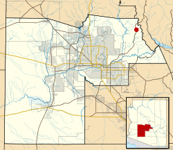
|image_map = Maricopa County Incorporated and Planning areas Sunflower location.svg |
|||
|image_map = |
|||
|mapsize = |
|mapsize = |
||
|map_caption = |
|map_caption = Location of Sunflower in Maricopa County, Arizona |
||
|image_map1 = |
|image_map1 = |
||
|mapsize1 = |
|mapsize1 = |
||
|map_caption1 = |
|map_caption1 = |
||
|pushpin_map = |
|pushpin_map = |
||
<!-- Location --> |
<!-- Location --> |
||
Revision as of 07:00, 19 May 2011
Sunflower, Arizona | |
|---|---|
Unincorporated community | |
 Location of Sunflower in Maricopa County, Arizona | |
| Country | United States |
| State | Arizona |
| County | Maricopa |
| Elevation | 3,405 ft (1,038 m) |
| Time zone | UTC-7 (Mountain (MST)) |
| Area code | 480 |
| GNIS feature ID | 34951[1] |
Sunflower is an unincorporated community in Maricopa County, Arizona, United States. Sunflower is located near Arizona State Route 87 Template:Mi to km northeast of Fountain Hills.

