
Raiya Chak Maddu: Difference between revisions
Ahmedraiya (talk | contribs) No edit summary |
Ahmedraiya (talk | contribs) No edit summary |
||
| Line 1: | Line 1: | ||
{{Infobox settlement |
{{Infobox settlement |
||
| name = Raiya Chak Maddu |
| name = Raiya Chak Maddu, Punjab |
||
| native_name = {{Nastaliq| رائیہ چک مدو }}<!-- If different from name --> |
| native_name = {{Nastaliq| رائیہ چک مدو }}<!-- If different from name --> |
||
| native_name_lang = ur<!-- ISO 639-2 code e.g. "fr" for French. If more than one, use {{lang}} instead --> |
| native_name_lang = ur<!-- ISO 639-2 code e.g. "fr" for French. If more than one, use {{lang}} instead --> |
||
Revision as of 12:27, 27 December 2013
Raiya Chak Maddu, Punjab
رائیہ چک مدو Raya Chak Maddo | |
|---|---|
Village | |
| Country | Pakistan |
| Region | Punjab Province |
| District | Jhelum District |
| Tehsil | Jhelum |
| Police Station | Saddar Jhelum District |
| Union Council | Monan[1][2] |
| Post Office | Village Lota |
| Elevation | 230 m (760 ft) |
| Time zone | UTC+5 (PST) |
| • Summer (DST) | UTC+6 (PST) |
| Postal Code | 49601 |
| Area code | 0544 |
| Local Bank | National Bank of Pakistan Muhammadi Bazar Branch Jhelum |
Raiya Chak Maddu (pronounced [raːiːjaː tʃək məd̪u]) is a village in the union council of Monan Jhelum Tehsil. The village is part of the Jhelum District of the Punjab province of Pakistan. This village is divided into three separate parts. One part, now called "Main Old Locality", comprises the dwellings of old inhabitants. The second part, called "New Abadi Dhoke Musalliyan" lies to the west of the main locality, and third part, called "New North-Western Abadi" adjacent to Village Bhumbalan lies north-west of the main locality; all three parts separated from each other by agricultural lands and being populated by new settlers.
Facilities
There are three mosques in village to say prayers situated each in all parts and a Basic Health Centre for the health care of the locals and people from adjacent villages. "Main Mosque" is situated within the older main locality whereas "New Mosque" and the "Basic Health Centre Kotla Faqir" are located within the jurisdiction of new western settlement (hereinafter to be referred as "New Settlement"). New Mosque has been constructed recently, therefore, named accordingly. And the third mosque named Khudai Mosque is located within the locality of New North-Western Settlement.
A big Water Tank/pond/Water Reservoir to waste used water and sewage lies in the western side of main locality whereas a Muslim graveyard along with a site fixed for funeral prayers called "Janaza Gah" is located adjacent to the northern side of the main locality. Local people raise water-buffalos which go for a swim into the pond and bathe in the summer hot.
There also lies Jattan Da Bagh (Mango and Date-Palm Orchard — Pride of Raiya) in the middle way of Main Old Locality and New North-Western Settlement, which was founded by Baba Dadu (Late) father of Baoo Noor Ahemd (Late) and Fazal Ahmed (Late) of Raiya, named after owners' family's caste being Jutt. This BAGH had every thing in it from black peper to mango trees and dates but sadly not being looked after by last 2 generations.
Geography and climate
Village lies at the foot of Pothohar Plateau and ground is fairly plain. It enjoys all 4 seasons. Summer is really hot and temperature can reach above 48°C during June and July. Monsoon starts in middle of July and lasts for 4–6 weeks. Winter is mostly dry and cold but December month is relatively wet and temperature can fall below 0°C.
Roads and paths
Village is well connected by different roads to other villages and Jhelum city. A metal road has been laid on south-eastern side of the main locality which leads to nearby Muhammadi Bazar along the Cantonement boundaries which boundary has been separated recently through a fence by Cantonment authorities. A paved path also leads to southern side to connect another metal road called Lota Road connecting Muhammadi Bazar and Village Chappar. From this juncture, Lota road further leads to Village Chappar on western side touching the southern boundaries of New Settlement. Another wide paved road constructed recently also connects the main locality of the village to the historical Rohtas Road near Village Chittan from north-eastern side. Heavy and light vehicles can easily approach the boundaries of main locality from all above three sides although cannot cross the locality due to its narrow streets. Light vehicles can approach to the Funeral Site and the Graveyard through south-eastern metal road whereas Light and Heavy transport can approach the same through north-eastern road without any obstacle. Streets of main locality are completely paved but require the attention of Local Bodies in the New Settlement and New North-Western Settlement for this purpose.
History
Village Raiya Chak Maddu derives its name by blend of two words i.e. “Raiya” and “Chak Maddu”. Basically the present location was called “Raiya” whereas “Chak Maddu” lied to its north eastern side near Historical Rohtas Road nearby Village Chittan opposite to present day Brick Kiln owned by Ch Arshad Mehmood Advocate on Chittan-Raiya Road where somebody can still trace the remains of such settlement.
The word Chak Maddu rhymes with the word Chak Bhuddo which is a nearby Village lying on the northern side of present Village Raiya Chak Maddu. Historically, the word “Chak” as an affix or suffix of the names of settlements or villages on the banks of some canal or water course indicates a planned small colony whose inhabitants are of one or more clans, set up by some official arrangement by the government or ruler to promote agriculture. Such a settlement supported adjoining agricultural lands by irrigating them from the canal or water course. Therefore, Chak Maddu definitely was such sort of village lying nearby historical Grand Trunk Road (Sharah-e-Azam well-built since the era of King Sher Shah Suri of Muslim India).
History of Jhelum reveals that in the Ghakkhar Era, Rani of Ghakkhars officiating his minor son Bujj Shah as regent of this region, planned to complete a task of excavating a canal, later on to be called “Rani Bah or Ghakkhari Nehr”, originally proposed by her predecessor husband Sultan Ghakkhar Shah of Ghakkhar extraction. This canal originated from the right bank of River Jhelum nearby her capital town (Raj Gaddi) of the regency called Varyam presently located across the Mangla Dam near the historical Village Sultanpur. Present day disused town of Varyam, later on, in an attack on it, in a controversy to take hold of the region, is known to be extirpated by King Saleem Shah Suri or Islam Shah Suri of Muslim India being capital town of the Ghakkhar tribe who inflicted continuous fierce battles against him to challenge his writ and authority; remains of which still can be seen in that area. Rani Bah, originated from this town, passed by the Villages Baral, Jallo Chak up to Bura Pindi; from whereon it split into two separate sections. Left section joined to River Jhelum making way between Villages Chak Hafizan and Chak Daulat while crossing through the Villages of Chak Daria, Qazi Chak, Chak Jamal, Chak Braham, Chak Nasir-ud-Din, Chak Lateef Ullah etc. in a zigzag shape. The other section led to Jallo Chak passing by Chak Abdul Khalik and further crossing the present GT Road, it entered into small hilly area of present day Langar Pur Pabbi. It further crossed through the Villages Chak Essa, Chak Bhuddo, disused Village Chak Nanak near Village Banni, Miana Chak and finally, on its tail, passed by Village Chak Maddu prior to its final destination into River Jhelum. It remained in use till Sikh Era or Sikh Empire although it became disused in British Era with the passage of time.
Routes of the canal are still visible and even recoded as Rani Bah in the official records of Department of Revenue at some places. The word “Chak” making part of names of above villages as affix or suffix clearly corroborates the historicity of the Canal (Rani Bah).
The names of two Villages “Raiya” and “Chak Maddu”, later on, merged into composite Village Raiya Chak Maddu when inhabitants of Village Chak Maddu migrated to Village Raiya at the present place to avoid continuous annual flooding which had been affecting them always in the past.
Agriculture
Majority of inhabitants got freehold. Adjoining soil of the main locality is fertile but sandy in and around the New Settlement. Local farmers, in the past, depended mostly on "persian wheel system" pulled by a yoke of oxen or seasonal rainfall to irrigate their agricultural fields which now has been replaced by modern Tubewells, changing from petrol or diesel to electric tubewells. Customary way of ploughing also has been replaced by modern tractors which saves time and hard work. Farmers yield different crops in different seasons including major crops of wheat and millet.
Notable people

- Syed Manzoor ul Hassan Hashmi (Late) Ex-Wing Commander PAF;
Gallery
-
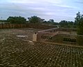 Village Scene
 -
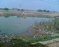 Village Main Pond
 -
 Village Main Pond


Nearby locations
| Direction | Villages and Places | Direction | Villages and Places |
|---|---|---|---|
| North |
|
North East |
|
| South |
|
South West |
|
| East |
|
South East |
|
| West |
|
North West |
|
References
