Washuk District: Difference between revisions
No edit summary |
Cyberbot II (talk | contribs) Rescuing 2 sources. #IABot |
||
| Line 55: | Line 55: | ||
==Administration== |
==Administration== |
||
Washuk District was once part of [[Kharan District]] in Balochistan province. It was declared a separate district in 2007, but its governance issues are largely managed by Kharan’s district administration.<ref> |
Washuk District was once part of [[Kharan District]] in Balochistan province. It was declared a separate district in 2007, but its governance issues are largely managed by Kharan’s district administration.<ref>{{cite web|url=http://nation.com.pk/pakistan-news-newspaper-daily-english-online/Regional/Islamabad/13-Dec-2011/No-Shamsi-base-outsourcing |accessdate=December 13, 2011 |deadurl=yes |archiveurl=https://web.archive.org/20111213065759/http://nation.com.pk/pakistan-news-newspaper-daily-english-online/Regional/Islamabad/13-Dec-2011/No-Shamsi-base-outsourcing |archivedate=December 13, 2011 }}</ref> |
||
Washuk District is further subdivided into 3 ''tehsils'' or subdistricts, 10 union councils and 216 ''mauzas'' (villages).<ref name="eyconsol1"> |
Washuk District is further subdivided into 3 ''tehsils'' or subdistricts, 10 union councils and 216 ''mauzas'' (villages).<ref name="eyconsol1">{{cite web|url=http://www.eyconsol.com/dmo/demo/BalochistanDP/Washuk.html |accessdate=December 13, 2011 |deadurl=yes |archiveurl=https://web.archive.org/20111124034728/http://www.eyconsol.com:80/dmo/demo/BalochistanDP/Washuk.html |archivedate=November 24, 2011 }}</ref> |
||
==Geography== |
==Geography== |
||
Revision as of 05:47, 26 February 2016
This article needs additional citations for verification. (November 2013) |
This article possibly contains original research. (January 2016) |
Washuk District
ضلع | |
|---|---|
| Washuk District | |
 | |
| Country | Pakistan |
| Province | Balochistan |
| Established | 2007 |
| Headquarters | Washuk |
| Government | |
| • Deputy Commissioner | Salahuddin Norzai |
| • Commissioner | Dr. Muhammad Akbar Harifal |
| Area | |
| • Total | 29,510 km2 (11,390 sq mi) |
| Time zone | UTC+5 (PST) |
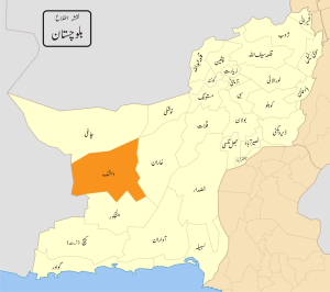
Washuk District (Template:Lang-bal) is a district in Balochistan province of Pakistan. Washuk town, the district headquarters, is located at the center of the district.
Administration
Washuk District was once part of Kharan District in Balochistan province. It was declared a separate district in 2007, but its governance issues are largely managed by Kharan’s district administration.[1]
Washuk District is further subdivided into 3 tehsils or subdistricts, 10 union councils and 216 mauzas (villages).[2]
Geography
Washuk District is spread over 29,510 km2, of which 71,520 hectares is arable. The rest consists mostly of barren desert and mountains of the Central Makran Range.[2]
Education
According to the Alif Ailaan Pakistan District Education Rankings 2014, Washuk is ranked 131 out of 146 districts in Pakistan in terms of the quality of education. For facilities and infrastructure, the district is ranked 132 out of 146. [3] A detailed picture of the district's education performance is also available online. [4]
References
- ^ https://web.archive.org/20111213065759/http://nation.com.pk/pakistan-news-newspaper-daily-english-online/Regional/Islamabad/13-Dec-2011/No-Shamsi-base-outsourcing. Archived from the original on December 13, 2011. Retrieved December 13, 2011.
{{cite web}}: Missing or empty|title=(help); Unknown parameter|deadurl=ignored (|url-status=suggested) (help) - ^ a b https://web.archive.org/20111124034728/http://www.eyconsol.com:80/dmo/demo/BalochistanDP/Washuk.html. Archived from the original on November 24, 2011. Retrieved December 13, 2011.
{{cite web}}: Missing or empty|title=(help); Unknown parameter|deadurl=ignored (|url-status=suggested) (help) - ^ "Alif Ailaan Pakistan District Education Rankings, 2014" (PDF). Alif Ailaan. Retrieved 2014-05-06.
- ^ "Individual district profile link, 2014" (PDF). Alif Ailaan. Retrieved 2014-05-06.

