
Agua Fria River: Difference between revisions
m Robot - Moving category Rivers and streams of Arizona to Category:Rivers of Arizona per CFD at Wikipedia:Categories for discussion/Log/2016 July 11. |
Rescuing 1 sources and tagging 1 as dead. #IABot (v1.2.4) |
||
| Line 5: | Line 5: | ||
During rainy times when water flows in the intermittent Agua Fria River, it discharges into the [[Gila River]], which is also a river that flows only during wet periods of the year. |
During rainy times when water flows in the intermittent Agua Fria River, it discharges into the [[Gila River]], which is also a river that flows only during wet periods of the year. |
||
The [[Central Arizona Project|Central Arizona Water Conservation District]] of the [[Central Arizona Project]] operates the Agua Fria Recharge Project, which is about {{convert|4|mi|km}} south of the [[New Waddell Dam]]. It serves to recharge underground aquifers in this area, and ends at Lake Pleasant, Phoenix.<ref>[http://www.cap-az.com/static/index.cfm?contentID=65 Agua Fria Recharge Project]</ref> |
The [[Central Arizona Project|Central Arizona Water Conservation District]] of the [[Central Arizona Project]] operates the Agua Fria Recharge Project, which is about {{convert|4|mi|km}} south of the [[New Waddell Dam]]. It serves to recharge underground aquifers in this area, and ends at Lake Pleasant, Phoenix.<ref>[http://www.cap-az.com/static/index.cfm?contentID=65 Agua Fria Recharge Project] {{wayback|url=http://www.cap-az.com/static/index.cfm?contentID=65 |date=20080117054314 }}</ref> |
||
==Gallery== |
==Gallery== |
||
| Line 28: | Line 28: | ||
== External links == |
== External links == |
||
* [http://www.maricopaaudubon.org/web-content/birding_locations/agua_fria.htm Maricopa Audubon Society Page on the Agua Fria Wildlife Preserve] |
* [http://www.maricopaaudubon.org/web-content/birding_locations/agua_fria.htm Maricopa Audubon Society Page on the Agua Fria Wildlife Preserve] |
||
* [http://magwww.mag.maricopa.gov/archive/wvtrails/index.html Agua Fria River Master Plan], by [[Maricopa County]] |
* [http://magwww.mag.maricopa.gov/archive/wvtrails/index.html Agua Fria River Master Plan]{{dead link|date=October 2016 |bot=InternetArchiveBot |fix-attempted=yes }}, by [[Maricopa County]] |
||
* [http://www.nrcd.org/aguafria/ Agua Fria - New River Natural Resource Conservation District] |
* [http://www.nrcd.org/aguafria/ Agua Fria - New River Natural Resource Conservation District] |
||
* [http://www.pbase.com/bobglen97/agua_fria_river Photos taken along the Agua Fria River] |
* [http://www.pbase.com/bobglen97/agua_fria_river Photos taken along the Agua Fria River] |
||
Revision as of 20:08, 5 October 2016

The Agua Fria River is a 120-mile (190 km) long intermittent stream which flows generally south from 20 miles (32 km) east-northeast of Prescott in the U.S. state of Arizona. Prescott draws much of its municipal water supply from the upper Agua Fria drainage.[1] The Agua Fria runs through the Agua Fria National Monument. The river then flows through a small canyon called "Black Canyon" into Lake Pleasant, a popular recreation area near Peoria, Arizona. (There is a large "Black Canyon" on the Colorado River along the Arizona–Nevada border.)
During rainy times when water flows in the intermittent Agua Fria River, it discharges into the Gila River, which is also a river that flows only during wet periods of the year.
The Central Arizona Water Conservation District of the Central Arizona Project operates the Agua Fria Recharge Project, which is about 4 miles (6.4 km) south of the New Waddell Dam. It serves to recharge underground aquifers in this area, and ends at Lake Pleasant, Phoenix.[2]
Gallery
-
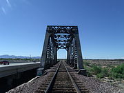 The historic "Agua Fria River Bridge” was built by the Santa Fe Railroad over the Agua Fria River in 1895. It is located on the right side of Grand Ave. if traveled from Phoenix to Wickenburg, close to 111 Ave. in El Mirage, Arizona.
 -
 Different view of the historic "Agua Fria River Bridge”.
 -
 Agua Fria Canyon, near Richinbar Mine, Agua Fria National Monument


See also
References
External links
- Maricopa Audubon Society Page on the Agua Fria Wildlife Preserve
- Agua Fria River Master Plan[permanent dead link], by Maricopa County
- Agua Fria - New River Natural Resource Conservation District
- Photos taken along the Agua Fria River
- Bureau of Land Management Page on the Agua Fria National Monument
33°23′22″N 112°21′53″W / 33.3894873°N 112.364602°W