Ilog, Negros Occidental: Difference between revisions
Appearance
Content deleted Content added
m →top: clean up, replaced: Dialing code → {{areacodestyle}} using AWB |
Rescuing 2 sources and tagging 0 as dead. #IABot (v1.3beta4) |
||
| Line 27: | Line 27: | ||
| parts_style = para |
| parts_style = para |
||
| p1 = 15 |
| p1 = 15 |
||
| government_footnotes = <ref>{{cite web |
| government_footnotes = <ref>{{cite web|url=http://www.dilg.gov.ph/municipalities.php |title=Municipalities |publisher=Department of the Interior and Local Government |location=Quezon City, Philippines |accessdate=5 March 2013 |deadurl=yes |archiveurl=http://www.webcitation.org/6DvgcVRCD?url=http%3A%2F%2Fwww.dilg.gov.ph%2Fmunicipalities.php |archivedate=25 January 2013 |df= }}</ref> |
||
| leader_title = Mayor |
| leader_title = Mayor |
||
| leader_name = Genaro Rafael K. Alvarez |
| leader_name = Genaro Rafael K. Alvarez |
||
| Line 87: | Line 87: | ||
==External links== |
==External links== |
||
*[http://www.nscb.gov.ph/activestats/psgc/default.asp Philippine Standard Geographic Code] |
*[https://web.archive.org/web/20120413163013/http://www.nscb.gov.ph/activestats/psgc/default.asp Philippine Standard Geographic Code] |
||
*[https://web.archive.org/web/20160215003931/http://census.gov.ph/ Philippine Census Information] |
*[https://web.archive.org/web/20160215003931/http://census.gov.ph/ Philippine Census Information] |
||
*[http://www.blgs.gov.ph/lgpmsv2/cmshome/index.php?pageID=23&frmIdDcfCode=7&fLguType=CM&frmIdRegion=9&frmIdProvince=55&frmIdLgu=991 Local Governance Performance Management System] |
*[http://www.blgs.gov.ph/lgpmsv2/cmshome/index.php?pageID=23&frmIdDcfCode=7&fLguType=CM&frmIdRegion=9&frmIdProvince=55&frmIdLgu=991 Local Governance Performance Management System] |
||
Revision as of 13:04, 9 April 2017
Ilog | |
|---|---|
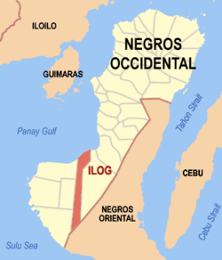
 Map of Negros Occidental with Ilog highlighted | |
| Coordinates: 10°02′N 122°46′E / 10.033°N 122.767°E | |
| Country | Philippines |
| Region | Negros Island Region (NIR) |
| Province | Negros Occidental |
| District | 6th district of Negros Occidental |
| Barangays | 15 |
| Government | |
| • Mayor | Genaro Rafael K. Alvarez |
| Area | |
| • Total | 281.70 km2 (108.76 sq mi) |
| Population (2010)[3] | |
| • Total | 54,423 |
| • Density | 190/km2 (500/sq mi) |
| Time zone | UTC+8 (PST) |
| ZIP code | 6109 |
| IDD : area code | 034 |
Ilog is a second class municipality in the province of Negros Occidental, Philippines. According to the 2010 census, it has a population of 54,423 people.[3]
Founded by the Augustinian Fathers Geronimo Marin and Francisco Bustos on May 16, 1584, it was the first capital of the historical military district/province of Negros in the late 18th century. The name Ilog (or Ylog, Tagalog for "river") was recommended by a Tagalog guide of the Spaniards because the place was entirely surrounded by the longest river on the whole Negros Island, the Ilog Hilabangan River. The first inhabitants of Ilog are mostly migrants from Panay island.
Barangays
Ilog is politically subdivided into 15 barangays.[2]
- Andulauan
- Balicotoc
- Bocana
- Calubang
- Canlamay
- Consuelo
- Dancalan
- Delicioso
- Galicia
- Manalad
- Pinggot
- Barangay I (Pob.)
- Barangay II (Pob.)
- Tabu
- Vista Alegre
Demographics
| Year | Pop. | ±% p.a. |
|---|---|---|
| 1990 | 46,599 | — |
| 1995 | 43,905 | −1.11% |
| 2000 | 46,252 | +1.12% |
| 2007 | 53,460 | +2.02% |
| 2010 | 54,423 | +0.65% |
| Source: National Statistics Office[3][4] | ||
References
- ^ "Municipalities". Quezon City, Philippines: Department of the Interior and Local Government. Archived from the original on 25 January 2013. Retrieved 5 March 2013.
{{cite web}}: Unknown parameter|deadurl=ignored (|url-status=suggested) (help) - ^ a b "Province: Negros Occidental". PSGC Interactive. Makati City, Philippines: National Statistical Coordination Board. Retrieved 5 March 2013.
- ^ a b c "Total Population by Province, City, Municipality and Barangay: as of May 1, 2010" (PDF). 2010 Census of Population and Housing. National Statistics Office. Archived from the original (PDF) on November 15, 2012. Retrieved 5 March 2013.
{{cite web}}: Unknown parameter|deadurl=ignored (|url-status=suggested) (help) - ^ "Province of Negros Occidental". Municipality Population Data. LWUA Research Division. Retrieved 19 August 2013.
External links
- Philippine Standard Geographic Code
- Philippine Census Information
- Local Governance Performance Management System

