Lutayan: Difference between revisions
Appearance
Content deleted Content added
Rescuing 3 sources and tagging 0 as dead. #IABot (v1.3.2.4) |
|||
| Line 33: | Line 33: | ||
| elevation_footnotes = |
| elevation_footnotes = |
||
| elevation_m = |
| elevation_m = |
||
| population_footnotes = <ref name=NSO10>{{cite web |
| population_footnotes = <ref name=NSO10>{{cite web|url=http://www.census.gov.ph/sites/default/files/attachments/hsd/pressrelease/SOCCSKSARGEN.pdf |title=Total Population by Province, City, Municipality and Barangay: as of May 1, 2010 |work=2010 Census of Population and Housing |publisher=National Statistics Office |accessdate=27 May 2014 |deadurl=yes |archiveurl=https://web.archive.org/web/20130320001730/http://www.census.gov.ph/sites/default/files/attachments/hsd/pressrelease/SOCCSKSARGEN.pdf |archivedate=20 March 2013 |df= }}</ref> |
||
| population_total = 56,179 |
| population_total = 56,179 |
||
| population_as_of = 2010 |
| population_as_of = 2010 |
||
| Line 94: | Line 94: | ||
==External links== |
==External links== |
||
* [http://www.nscb.gov.ph/activestats/psgc/default.asp Philippine Standard Geographic Code] |
* [https://web.archive.org/web/20120413163013/http://www.nscb.gov.ph/activestats/psgc/default.asp Philippine Standard Geographic Code] |
||
* [ |
* [https://web.archive.org/web/20131004104825/http://census.gov.ph/ Philippine Census Information] |
||
* [http://www.blgs.gov.ph/lgpmsv2/cmshome/index.php?pageID=23&frmIdDcfCode=7&fLguType=CM&frmIdRegion=15&frmIdProvince=78&frmIdLgu=1546 Local Governance Performance Management System] |
* [http://www.blgs.gov.ph/lgpmsv2/cmshome/index.php?pageID=23&frmIdDcfCode=7&fLguType=CM&frmIdRegion=15&frmIdProvince=78&frmIdLgu=1546 Local Governance Performance Management System] |
||
Revision as of 00:13, 28 May 2017
Lutayan | |
|---|---|
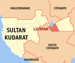
 Map of Sultan Kudarat with Lutayan highlighted | |
| Coordinates: 06°36′N 124°51′E / 6.600°N 124.850°E | |
| Country | Philippines |
| Region | Soccsksargen |
| Province | Sultan Kudarat |
| District | 1st district of Sultan Kudarat |
| Barangays | 11 |
| Government | |
| • Mayor | Ruth Mangudadatu-Sakaluran |
| Area | |
| • Total | 271.00 km2 (104.63 sq mi) |
| Population (2010)[3] | |
| • Total | 56,179 |
| • Density | 210/km2 (540/sq mi) |
| Time zone | UTC+8 (PST) |
| ZIP code | 9803 |
| IDD : area code | +63 (0)64 |
| Income class | 2nd |
Lutayan is a second class municipality in the province of Sultan Kudarat, Philippines. According to the 2010 census, it has a population of 56,179 people.[3]
This lakeside town shares Lake Buluan with its neighboring municipality, Buluan, Maguindanao. Lutayan was carved out from Buluan in 1966. The first appointed mayor was the wife of the then-mayor of Buluan, a royalty from the Rajah Buayan Sultanate, Bai Linilang Mangelen. She was also the first ever elected Mayor of the town and served for two decades.
Barangays
Lutayan is politically subdivided into 11 barangays.[2]
- Antong
- Bayasong
- Blingkong
- Lutayan Proper
- Maindang
- Mamali
- Manili
- Palavilla
- Sampao
- Sisiman
- Tamnag
Demographics
| Year | Pop. | ±% p.a. |
|---|---|---|
| 1970 | 9,581 | — |
| 1975 | 6,730 | −6.84% |
| 1980 | 19,090 | +23.18% |
| 1990 | 30,276 | +4.72% |
| 1995 | 34,654 | +2.56% |
| 2000 | 40,881 | +3.61% |
| 2007 | 51,640 | +3.27% |
| 2010 | 56,179 | +3.11% |
| Source: Philippine Statistics Authority[4][5][6][7] | ||
References
- ^ "Official City/Municipal 2013 Election Results". Intramuros, Manila, Philippines: Commission on Elections (COMELEC). 1 July 2013. Retrieved 5 September 2013.
- ^ a b "Province: Sultan Kudarat". PSGC Interactive. Makati City, Philippines: National Statistical Coordination Board. Retrieved 27 May 2014.
- ^ a b "Total Population by Province, City, Municipality and Barangay: as of May 1, 2010" (PDF). 2010 Census of Population and Housing. National Statistics Office. Archived from the original (PDF) on 20 March 2013. Retrieved 27 May 2014.
{{cite web}}: Unknown parameter|deadurl=ignored (|url-status=suggested) (help) - ^ Census of Population (2015). "Region XII (Soccsksargen)". Total Population by Province, City, Municipality and Barangay. Philippine Statistics Authority. Retrieved 20 June 2016.
- ^ Census of Population and Housing (2010). "Region XII (Soccsksargen)" (PDF). Total Population by Province, City, Municipality and Barangay. National Statistics Office. Retrieved 29 June 2016.
- ^ Censuses of Population (1903–2007). "Region XII (Soccsksargen)". Table 1. Population Enumerated in Various Censuses by Province/Highly Urbanized City: 1903 to 2007. National Statistics Office.
- ^ "Province of Sultan Kudarat". Municipality Population Data. Local Water Utilities Administration Research Division. Retrieved 17 December 2016.
External links
- Philippine Standard Geographic Code
- Philippine Census Information
- Local Governance Performance Management System

