
Checkpoint Charlie: Difference between revisions
ClueBot NG (talk | contribs) m Reverting possible vandalism by Cancer12333 to version by 174.60.156.201. Report False Positive? Thanks, ClueBot NG. (3242916) (Bot) |
Eintracht123 (talk | contribs) mNo edit summary |
||
| Line 10: | Line 10: | ||
'''Checkpoint Charlie''' (or "'''Checkpoint C'''") was the name given by the [[Western Bloc|Western Allies]] to the best-known [[Berlin Wall]] crossing point between [[East Berlin]] and [[West Berlin]] during the [[Cold War]] (1947–1991). |
'''Checkpoint Charlie''' (or "'''Checkpoint C'''") was the name given by the [[Western Bloc|Western Allies]] to the best-known [[Berlin Wall]] crossing point between [[East Berlin]] and [[West Berlin]] during the [[Cold War]] (1947–1991). |
||
[[File:Berlin-Mauermuseum am Checkpoint Charlie.jpg|thumb|[[Checkpoint Charlie Museum]]]] |
|||
[[File:Mauerkreuze am Checkpoint Charlie.jpg|thumb|The [[Freedom Memorial]]]] |
|||
[[East German]] leader [[Walter Ulbricht]] agitated and maneuvered to get the [[Soviet Union]]'s permission to construct the [[Berlin Wall]] in 1961 to stop [[Eastern Bloc emigration and defection]] westward through the Soviet border system, preventing escape across the city sector border from communist East Berlin into West Berlin. Checkpoint Charlie became a symbol of the Cold War, representing the separation of East and West. Soviet and American tanks briefly faced each other at the location during the [[Berlin Crisis of 1961]]. |
[[East German]] leader [[Walter Ulbricht]] agitated and maneuvered to get the [[Soviet Union]]'s permission to construct the [[Berlin Wall]] in 1961 to stop [[Eastern Bloc emigration and defection]] westward through the Soviet border system, preventing escape across the city sector border from communist East Berlin into West Berlin. Checkpoint Charlie became a symbol of the Cold War, representing the separation of East and West. Soviet and American tanks briefly faced each other at the location during the [[Berlin Crisis of 1961]]. |
||
Revision as of 11:50, 24 January 2018
This article needs additional citations for verification. (August 2017) |


Checkpoint Charlie (or "Checkpoint C") was the name given by the Western Allies to the best-known Berlin Wall crossing point between East Berlin and West Berlin during the Cold War (1947–1991).


East German leader Walter Ulbricht agitated and maneuvered to get the Soviet Union's permission to construct the Berlin Wall in 1961 to stop Eastern Bloc emigration and defection westward through the Soviet border system, preventing escape across the city sector border from communist East Berlin into West Berlin. Checkpoint Charlie became a symbol of the Cold War, representing the separation of East and West. Soviet and American tanks briefly faced each other at the location during the Berlin Crisis of 1961.
After the dissolution of the Eastern Bloc and the reunification of Germany, the building at Checkpoint Charlie became a tourist attraction. It is now located in the Allied Museum in the Dahlem neighborhood of Berlin.
Background

Emigration restrictions, the Inner German border and Berlin
By the early 1950s, the Soviet method of restricting emigration was emulated by most of the rest of the Eastern Bloc, including East Germany.[1] However, in occupied Germany, until 1952, the lines between East Germany and the western occupied zones remained easily crossed in most places.[2] Consequently, the inner German border between the two German states was closed and a barbed-wire fence erected.
Even after closing of the inner German border officially in 1952,[3] the city sector border in between East Berlin and West Berlin remained considerably more accessible than the rest of the border because it was administered by all four occupying powers.[2] Accordingly, Berlin became the main route by which East Germans left for the West.[4] Hence the Berlin sector border was essentially a "loophole" through which Eastern Bloc citizens could still escape.[3]
The 3.5 million East Germans who had left by 1961 totaled approximately 20% of the entire East German population.[5] The emigrants tended to be young and well educated.[6] The loss was disproportionately great among professionals — engineers, technicians, physicians, teachers, lawyers and skilled workers.[5]
Berlin Wall constructed
The brain drain of professionals had become so damaging to the political credibility and economic viability of East Germany that the re-securing of the Soviet imperial frontier was imperative.[7] Between 1949 and 1961, over 2½ million East Germans fled to the West.[8] The numbers increased during the three years before the Berlin Wall was erected,[8] with 144,000 in 1959, 199,000 in 1960 and 207,000 in the first seven months of 1961 alone.[8][9] The East German economy suffered accordingly.[9]
On August 13, 1961, a barbed-wire barrier that would become the Berlin Wall separating East and West Berlin was erected by the East Germans.[7] Two days later, police and army engineers began to construct a more permanent concrete wall.[10] Along with the wall, the 830 mile zonal border became 3.5 miles wide on its East German side in some parts of Germany with a tall steel-mesh fence running along a "death strip" bordered by mines, as well as channels of ploughed earth, to slow escapees and more easily reveal their footprints.[11]
-
 East German guards checking permits of bus passengers going through the checkpoint in October, just after the Wall was built on 13 August 1961
 -
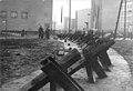 Czech hedgehogs just inside East Berlin
 -
 Checks by East German guards
 -
 US president John F Kennedy at Checkpoint Charlie in 1963
 -
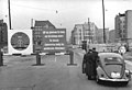
 The Western (foreground) and Eastern (background) checkpoints, with the latter's famous watchtower, which was demolished in 2000


Checkpoint


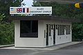
Checkpoint Charlie was a crossing point in the Berlin Wall located at the junction of Friedrichstraße with Zimmerstraße and Mauerstraße (which for older historical reasons coincidentally means 'Wall Street'). It is in the Friedrichstadt neighborhood. Checkpoint Charlie was designated as the single crossing point (by foot or by car) for foreigners and members of the Allied forces. (Members of the Allied forces were not allowed to use the other sector crossing point designated for use by foreigners, the Friedrichstraße railway station).
The name Charlie came from the letter C in the NATO phonetic alphabet; similarly for other Allied checkpoints on the Autobahn from the West: Checkpoint Alpha at Helmstedt and its counterpart Checkpoint Bravo at Dreilinden, Wannsee in the south-west corner of Berlin. The Soviets simply called it the Friedrichstraße Crossing Point ([КПП Фридрихштрассе, KPP Fridrikhshtrasse] Error: {{Lang}}: text has italic markup (help)). The East Germans referred officially to Checkpoint Charlie as the Grenzübergangsstelle ("Border Crossing Point") Friedrich-/Zimmerstraße.
As the most visible Berlin Wall checkpoint, Checkpoint Charlie is frequently featured in spy movies and books. A famous cafe and viewing place for Allied officials, armed forces and visitors alike, Cafe Adler ("Eagle Café"), is situated right on the checkpoint. It was an excellent viewing point to look into East Berlin while having something to eat and drink.
The checkpoint was curiously asymmetrical. During its 28-year active life, the infrastructure on the Eastern side was expanded to include not only the wall, watchtower and zig-zag barriers, but a multi-lane shed where cars and their occupants were checked. However, the Allied authority never erected any permanent buildings, and made do with the well-known wooden shed, which was replaced during the 1980s by a larger metal structure, now displayed at the Allied Museum in western Berlin. Their reason was that they did not consider the inner Berlin sector boundary an international border and did not treat it as such.
Related incidents
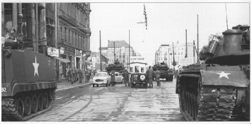
Stand-off between Soviet and U.S. tanks in October 1961

Soon after the construction of the Berlin Wall, a standoff occurred between U.S. and Soviet tanks on either side of Checkpoint Charlie. It began on 22 October as a dispute over whether East German guards were authorized to examine the travel documents of a U.S. diplomat named Allan Lightner passing through to East Berlin to see the opera. By October 27, 10 Soviet and an equal number of American tanks stood 100 yards apart on either side of the checkpoint. The standoff ended peacefully on October 28 following a U.S.-Soviet understanding to withdraw tanks. Discussions between U.S. Attorney General Robert F. Kennedy and KGB spy Georgi Bolshakov played a vital role in realizing this tacit agreement.[12]
Early escapes
The Berlin Wall was erected with great efficiency by the East German government in 1961, but there were many means of escape that had not been anticipated. For example, Checkpoint Charlie was initially blocked only by a gate, and a citizen of the DDR (East Germany) smashed a car through it to escape, so a strong pole was erected. Another escapee approached the barrier in a convertible, the windscreen removed prior to the event, and slipped under the barrier. This was repeated two weeks later, so the East Germans duly lowered the barrier and added uprights.[13]
Death of Peter Fechter
On 17 August 1962, a teenaged East German, Peter Fechter, was shot in the pelvis by East German guards while trying to escape from East Berlin. His body lay tangled in a barbed wire fence, and he bled to death, in full view of the world's media. American soldiers could not rescue him because he was a few metres inside the Soviet sector. East German border guards were reluctant to approach him for fear of provoking Western soldiers, one of whom had shot an East German border guard just days earlier. More than an hour later, Fechter's body was removed by the East German guards. A spontaneous demonstration formed on the American side of the checkpoint, protesting the action of the East and the inaction of the West.
A few days later, the crowd stoned Soviet buses driving towards the Soviet War Memorial, located in the Tiergarten in the British sector; the Soviets tried to escort the buses with armoured personnel carriers (APCs). Thereafter, the Soviets were only allowed to cross via the Sandkrug Bridge crossing (which was the nearest to Tiergarten) and were prohibited from bringing APCs. Western units were deployed in the middle of the night in early September with live armaments and vehicles, in order to enforce the ban.[citation needed]
Today


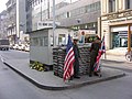
Although the wall was opened in November 1989 and the checkpoint booth removed on June 22, 1990,[14] the checkpoint remained an official crossing for foreigners and diplomats until German reunification during October 1990 when the guard house was removed; it is now on display in the open-air museum of the Allied Museum in Berlin-Zehlendorf.[15] The course of the former wall and border is now marked in the street with a line of cobblestones. A copy of the guard house and sign that once marked the border crossing was later built where Checkpoint Charlie once was. It resembles the first guard house erected during 1961, behind a sandbag barrier toward the border. Over the years it was replaced several times by guard houses of different sizes and layouts (see photographs). The one removed during 1990 was considerably larger than the first one and did not have sandbags.
Checkpoint Charlie Museum
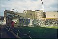
Near the location of the guard house is the Haus am Checkpoint Charlie. The "Mauermuseum - Museum Haus am Checkpoint Charlie" was opened on June 14, 1963, in the immediate vicinity of the Berlin Wall. It shows photographs and fragments of the separation of Germany. From 31 October 2004 until the evacuation on 5 July 2005, the Freedom Memorial, a newly erected white painted wall made of original wall segments and 1,067 commemorative crosses for the victims of the GDR border regime stood on a leased site.[16] The border fortifications and the "assistance of the protecting powers" are illustrated. In addition to photos and documentation of successful escape attempts, the exhibition will also showcase escape agents: hot-air balloons, escape cars, chair lifts and a mini-submarine.
The museum is operated by the "Arbeitsgemeinschaft 13. August e. V.", founded in 1963 by Dr. Rainer Hildebrandt. The museum is run by Alexandra Hildebrandt, the founder's widow. The museum is housed in the house at Checkpoint Charlie by architect Peter Eisenman.
With 850,000 visitors in 2007, the Wall Museum is one of the most visited museums in Berlin and in Germany. [17]
Other
Developers demolished the East German checkpoint watchtower in 2000, to make way for offices and shops. The watchtower was the last surviving original Checkpoint Charlie structure. The city tried to save the tower but failed, as it was not classified as a historic landmark. As of August 2011, nothing has been built at this site and the original proposals for development have been terminated.
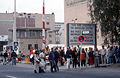
Checkpoint Charlie has become one of Berlin's primary tourist attractions. An open-air exhibit was opened during the summer of 2006. Gallery walls along the Friedrichstraße and the Zimmerstraße inform on escape attempts, how the checkpoint was expanded, and its significance during the Cold War, in particular the confrontation of Soviet and American tanks in 1961. An overview of other important memorial sites and museums on the division of Germany and the wall is presented as well. Tourists can have their photographs taken for a fee with actors dressed as allied military policemen standing in front of the guard house. Several souvenir stands with fake military items and stores proliferate as well.
-
 Removal of the famous checkpoint booth on 22 June 1990
 -
 Checkpoint Charlie in January 1991
 -
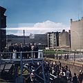
 Getting the souvenir pictures in January 1990 before everything disappears
 -
 Remnants of the Wall at Checkpoint Charlie in July 1990
 -
 The Checkpoint Charlie building at the time of the fall of the Berlin Wall, at its current site at the AlliiertenMuseum
 -
 "MP" actors for photograph hire
 -
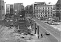
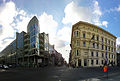 Checkpoint Charlie's location in 2011


In popular culture
British spy James Bond (played by Roger Moore) passed through Checkpoint Charlie in the film Octopussy (1983) from West Berlin to East.[18]
Checkpoint Charlie is featured in the opening scene of the 1965 Martin Ritt film The Spy Who Came in from the Cold (starring Richard Burton and Claire Bloom), based on the John le Carré novel of the same name.
See also
- Checkpoint Bravo
- Eastern Bloc emigration and defection
- Helmstedt–Marienborn border crossing (Checkpoint Alpha)
References
- ^ Dowty 1989, p. 114
- ^ a b Dowty 1989, p. 121
- ^ a b Harrison 2003, p. 99
- ^ Maddrell, Paul (2006). Spying on Science: Western Intelligence in Divided Germany 1945–1961. Oxford University Press. p. 56.
- ^ a b Dowty 1989, p. 122
- ^ Thackeray 2004, p. 188
- ^ a b Pearson 1998, p. 75
- ^ a b c Gedmin, Jeffrey. "The Dilemma of Legitimacy". The hidden hand: Gorbachev and the collapse of East Germany. AEI studies. Vol. 554. American Enterprise Institute. p. 35. ISBN 978-0-8447-3794-2.
- ^ a b Dowty 1989, p. 123
- ^ Dowty 1989, p. 124
- ^ Black et al. 2000, p. 141
- ^ Kempe, Frederick (2011). Berlin 1961. Penguin Group (USA). pp. 478–479. ISBN 0-399-15729-8.
- ^ Dearden, Lizzie. "Berlin Wall: What You Need To Know About the Barrier That Divided East and West". Independent.co.uk. Retrieved 16 September 2017.
- ^ "June 22, 1990: Checkpoint Charlie Closes". ABC News. Retrieved 21 June 2011.
- ^ "Allied Museum Berlin". Archived from the original on 2008-06-21.
{{cite web}}: Unknown parameter|deadurl=ignored (|url-status=suggested) (help) - ^ http://www.npr.org/templates/story/story.php?storyId=4730106
- ^ https://www.berlin.de/tourismus/fotos/sehenswuerdigkeiten-fotos/3331172-1355138.gallery.html?page=4
- ^ http://www.jamesbondmm.co.uk/locations/checkpoint-charlie
- Sources
- Black, Cyril E.; English, Robert D.; Helmreich, Jonathan E.; McAdams, James A. (2000), Rebirth: A Political History of Europe since World War II, Westview Press, ISBN 0-8133-3664-3
- Dowty, Alan (1989), Closed Borders: The Contemporary Assault on Freedom of Movement, Yale University Press, ISBN 0-300-04498-4
- Dowty, Alan (1988), "The Assault on Freedom of Emigration", World Affairs, 151 (2)
- Harrison, Hope Millard (2003), Driving the Soviets Up the Wall: Soviet-East German Relations, 1953–1961, Princeton University Press, ISBN 0-691-09678-3
- Pearson, Raymond (1998), The Rise and Fall of the Soviet Empire, Macmillan, ISBN 0-312-17407-1
- Thackeray, Frank W. (2004), Events that changed Germany, Greenwood Publishing Group, ISBN 0-313-32814-5
External links
| External media | |
|---|---|
| Images | |
| Video | |
 Media related to Checkpoint Charlie at Wikimedia Commons
- Museum Haus am Checkpoint Charlie

Visitor attractions in Berlin | ||
|---|---|---|
| Mitte |
|  |
| Western Berlin |
| |
| Eastern Berlin | ||
| Metropolitan region | ||
| International | |
|---|---|
| National | |
- Berlin Wall
- 1990 disestablishments in West Germany
- Berlin border crossings
- Allied occupation of Germany
- Checkpoints
- Cold War sites in Germany
- Buildings and structures in Mitte
- Buildings and structures in Friedrichshain-Kreuzberg
- 1961 establishments in East Germany
- Rebuilt buildings and structures in Berlin
- Tourist attractions in Berlin
- 1990 disestablishments in East Germany
- 1961 establishments in West Germany