
Canlubang: Difference between revisions
Reverted to revision 840021902 by David.moreno72 (talk): Unsourced. (TW) |
Jhoven Sulla (talk | contribs) No edit summary |
||
| Line 29: | Line 29: | ||
| subdivision_name3 = [[Laguna (province)|Laguna]] |
| subdivision_name3 = [[Laguna (province)|Laguna]] |
||
| subdivision_name4 = [[Calamba, Laguna|Calamba]] |
| subdivision_name4 = [[Calamba, Laguna|Calamba]] |
||
| subdivision_name5 = |
| subdivision_name5 = [[Kapayapaan Village, Canlubang|Kapayapaan]] |
||
| subdivision_name6 = [[Barrio Canlubang|Bo. Canlubang]] |
| subdivision_name6 = [[Barrio Canlubang|Bo. Canlubang]] |
||
| leader_title = Chairman |
| leader_title = Chairman <!-- Current Election --> |
||
| leader_name = Larry O. Dimayuga |
| leader_name = Larry O. Dimayuga {{small|(''still remain'')}} |
||
| postal_code_type = ZIP code <!-- The postal code of Canlubang is 4028, excluding of Calamba --> |
| postal_code_type = ZIP code <!-- The postal code of Canlubang is 4028, excluding of Calamba --> |
||
| postal_code = 4028 |
| postal_code = 4028 |
||
Revision as of 11:30, 14 May 2018
Canlubang | |
|---|---|
| Barangay Canlubang | |
 The Republ1c Wakepark at Nuvali in Canlubang | |
 Seal | |
| Coordinates: 14°11′31″N 121°4′16″E / 14.19194°N 121.07111°E | |
| Country | Philippines |
| Islands | Luzon |
| Region | Calabarzon (Region IV-A) |
| Province | Laguna |
| City | Calamba |
| Largest area | Kapayapaan |
| Center | Bo. Canlubang |
| Government | |
| • Chairman | Larry O. Dimayuga (still remain) |
| Area | |
| • Land | 39.12 km2 (15.10 sq mi) |
| Population (2014) | |
| • Total | 63,571[1] |
| ZIP code | 4028 |
Canlubang is a major industrial zone located in the province of Laguna, southwest of Metro Manila in the Philippines. It was once a hacienda during the Spanish colonial period. Canlubang straddles two component cities of Laguna: Cabuyao, Calamba and the municipality of Silang in Cavite.
The official political unit with the name Canlubang is a barangay in Calamba City, Laguna. It is the largest and most populated barangay in Calamba.
Canlubang covers major industrial zones. It extends as far as Cabuyao and Santa Rosa, Laguna where the Nuvali Evoliving development of Ayala Land is located.
History
The history of Canlubang can be traced back to the 16th century. It was originally owned by a group of sangleys residing in Calamba. It was confiscated by the government and sold at a public auction to a peninsular Spaniard, Don Tomas de Andaya in 1678. It was then acquired by the Jesuits in 1759. When the Jesuits were expelled in the Philippines, the land was again confiscated by the government and sold again at a public auction to Don Jose Clemente de Azanza in 1802. It was acquired by the Dominicans in 1830...
Canlubang Sugar Estate
When the Americans colonized the country, the land was classified as friar land and was again acquired by the government in 1905. Alfred Ehrman, leader of a group of American businessmen from California, organized and incorporated the Calamba Sugar Estate in 1912 which purchased the friar land. The Calamba Sugar Estate managed by Louis Weinzheimer and his family is known as the second sugar central in the Philippines. The sugar mill started its operations on December 1, 1914. It also planted coconuts on its property and was a model sugar plantation from 1920 to 1930s.

The Americans sold the estate to Vicente Madrigal on the onset of the Japanese occupation of the Philippines. In 1948, Madrigal was unable to run the estate successfully due to labor unrest. He offered the estate to a good friend, José Yulo, a bright lawyer and legal counsel of the estate since 1927 who had served as Speaker of the House of Representatives before World War II and Chief Justice of the Supreme Court during the Japanese Occuptaion. The Yulos acquired the estate in 1948 and improved the financial and social status of the estate within two years through reforms. His wife, Cecilia Araneta Yulo was instrumental in the construction of a school (now Rizal Institute), the church of St. Joseph, civic and recreational centers, and the first outdoor drive-in moviehouse. Sports facilities such as the baseball field, swimming pools, tennis courts, bowling lanes and golf course were also built. The company was also expanded into a pulp facility known as the Canlubang Pulp which purchased more than 80% of the total abaca produced in the country.
During the 1970s, less land was available for sugarcane since planters sold their land to developers or converted them into subdivisions. Profit of the mill is decreasing. The Yulos realized a need for a comprehensive master plan for the estate. They sought the assistance of National Artist for Architecture Leandro V. Locsin and the Canlubang Urban Project was born. Locsin designed Canlubang as a pioneer sustainable satellite city to attract investors in Laguna. In 1972, the first integrated industrial park was built outside Metro Manila. Canlubang became the catalyst of what is now known as Project CALABARZON.[2]
Geography
Canlubang is bordered by Cabuyao to the north, the barangays of Mapagong, Mayapa, Sirang Lupa and Majada Out of Calamba to the east, by the barangays of Laguerta, Hornalan and Bunggo of Calamba to the south and by Silang, province of Cavite to the west.[3]
Canlubang has a total land area of 3,912 hectares (9,666.8 acres) making it the largest barangay in Calamba in terms of land area and one of the largest in the country.[2] Half of its land (or 50%) is undeveloped agricultural land, 20% is residential, 20% is industrial and 10% is commercial. It is classified as a rural area and land use falls under the Growth Management Zone 1 & 2. Two industrial parks are currently situated in Canlubang. These are the Silangan Industrial Park and the Carmelray Industrial Park 1 which uses 200 and 202 hectares of land respectively.[4]
Sitios and Puroks
As a barangay, there are 21 sitios or puroks in Canlubang. Each sitio is headed by a sitio chairman (or punong kinatawan). These sitios are:
- ‡ Urban Sitio
- ± Independent Component Sitio
- † Barrio & Urban Sitio
- ∗ Component Sitio
- Common Sitio
| Sitio's of Canlubang | |||
|---|---|---|---|
| Sitio's | Classification | Status | Area |
| ‡ Asia I | Urbanized Sitio | Urban | Kapayapaan Area |
| * Asia II | Component Sitio | ||
| Balagbag Araw/Kapatagan | Upland Sitio | Rural | Upland Area |
| Buntog | |||
| † Canlubang | Barrio & Urbanized Sitio | Urban | Proper Area |
| ± Carmel | Independent Sitio | Rural | Independent Area |
| † Casmicejos | Barrio Sitio | Proper Area | |
| Ceris I & II | Subdivision Sitio | Independent Area | |
| * Ceris III | Component Sitio | ||
| Happy Valley | Redevelopment Sitio | Proper Area | |
| Kapatagan B-1 | Subdivision Sitio | Urban | |
| Locomotive | Redevelopment sitio | Rural | Independent Area |
| Majada-In | Subdivision sitio | Upland Area | |
| Mangumit I | |||
| * Mangumit II | Component Sitio | ||
| ± Manphil | Independent Component Sitio | Urban | Kapayapaan Area |
| * MCDC | Component Sitio | ||
| Old Stable | Redevelopment Sitio | Rural | Proper Area |
| * Palao | Component Sitio | Urban | Kapayapaan Area |
| Putol | Redevelopment Sitio | Rural | Upland Area |
| ‡ Silangan Village | Urbanized Sitio | Urban | Independent Area |
Demographics
| Year | Pop. | ±% p.a. |
|---|---|---|
| 1980 | 18,659 | — |
| 1990 | 20,112 | +0.75% |
| 1995 | 34,484 | +10.63% |
| 2000 | 45,294 | +6.02% |
| 2007 | 54,602 | +2.61% |
| 2010 | 54,655 | +0.04% |
According to the 2010 census, Barangay Canlubang has a population of 54,655 inhabitants, making it the most populated barangay in Calamba City.[3]
Religion

Canlubang is predominantly Roman Catholic. Other religious sects in the community are Protestants, Baptist, Iglesia ni Cristo and Islam.
It is the only barangay in the province of Laguna under the Roman Catholic Diocese of San Pablo that hosts a patron saint for itself, St. Joseph the Worker, whose feast is celebrated every May 1.
The Diocesan Shrine of Mary Help of Christians is also located in Canlubang. The shrine is under the care of the Salesians.
Economy
The income of Canlubang mainly comes from manufacturing and economic plants located from the industrials in this barangays like, some industrial park, Carmelray Industrial Park 1 and Silangan Industrial Park or also known as Canlubang Industrial Estate.
Banking
Industries and Manufacturing
As a premiere industrial hub outside Manila, several industrial parks are located in the barangay. These include Carmelray Industrial Park I, Carmelray International Business Park, NYK-TDG IT Park and Silangan Industrial Park.[5]
Commerce and Trades
Several shopping centers and commercial establishments can also be found within Canlubang. These include Carmel Mall, (dubbed as the Canlubang Community Shopping Center), Puregold - Canlubang located inside Carmel Mall, iMall Canlubang, Robinson's Supermarket - located inside iMall Canlubang and Puregold Extra Canlubang (located in Asia 1, Kapayapaan Village).
Tourism and places of interest
- San Jose Manggagawa Parish: The Saint Joseph the Worker Parish is built on a small hill. It houses the Yulo mausoleum. Leandro V. Locsin, National Artist for Architecture is interred here.
- Canlubang Golf & Country Club: Is the largest country club located at Laguna in western part. and in the Philippines.
- The Mills Country Club
- Republ1c Wakepark
- Rizal Shrine in Canlubang:
- Diocesan Shrine of Mary Help of Christians: Home of the Salesians in Canlubang.
- Matang Tubig Falls
Highlights and awards
- First barangay in the Philippines that implemented the Employment Service Office through the establishment of the Barangay Employment Service Office (BESO)
- First barangay in Calamba City to have Manpower Satellite Training Facility
- 2012 Model Barangay Hall, awarded by the Department of Interior and Local Government (DILG)
- 2012 Eco-Friendly Barangay, awarded by the Department of Interior and Local Government (DILG)
- 2011 Model Barangay, awarded by the Department of Interior and Local Government (DILG)
See also
Gallery
-
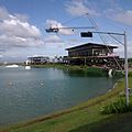 Republ1c Wakepark
 -
 Diocesan Shrine of Mary Help of Christians in Canlubang
 -
 Matang Tubig falls
 -
Larry O. Dimayuga, speech in Sitio Asia-2


References
- ^ Balba, Renen. "calambacity.gov.ph - Brgy Canlubang". www.calambacity.gov.ph. Retrieved 3 March 2017.
- ^ a b "Canlubang". Barangay Canlubang Magazine (2). October 2013.
- ^ a b "Brgy Canlubang | Barangay Profile". City Government of Calamba. Archived from the original on September 3, 2014. Retrieved August 26, 2014.
- ^ http://wikimapia.org/32203232/Matang-Tubig-Balagbag-Araw
- ^ "Operating Economic Zones".
External links
Places adjacent to Canlubang | ||||||||||||||||
|---|---|---|---|---|---|---|---|---|---|---|---|---|---|---|---|---|
| ||||||||||||||||
| Geography |
| ||||||
|---|---|---|---|---|---|---|---|
| City |
| ||||||
| Officials | |||||||
| History |
| ||||||
| Barangays |
| ||||||
| Sister cities | |||||||
| Notable people | |||||||