
Wikipedia:Graphics Lab/Map workshop: Difference between revisions
m →Eleanor cross: forgot to sign |
No edit summary |
||
| Line 254: | Line 254: | ||
;Request: |
;Request: |
||
: This article includes a map ([[Data:Eleanor cross.map]]), which used to show a section of England running from Lincoln in the north to London in the south, with the locations of the 12 [[Eleanor cross]]es marked. I have no idea what has happened, but in the past few weeks the map as displayed in the article has shifted northwards, so that it is now centred on Lincoln, and only shows the northernmost 5 of the crosses in the bottom half. Can somebody please look at it and fix the problem? Thanks. [[User:GrindtXX|GrindtXX]] ([[User talk:GrindtXX|talk]]) 21:22, 9 August 2019 (UTC) |
: This article includes a map ([[Data:Eleanor cross.map]]), which used to show a section of England running from Lincoln in the north to London in the south, with the locations of the 12 [[Eleanor cross]]es marked. I have no idea what has happened, but in the past few weeks the map as displayed in the article has shifted northwards, so that it is now centred on Lincoln, and only shows the northernmost 5 of the crosses in the bottom half. Can somebody please look at it and fix the problem? Thanks. [[User:GrindtXX|GrindtXX]] ([[User talk:GrindtXX|talk]]) 21:22, 9 August 2019 (UTC) |
||
;Discussion: |
|||
==Mande Heartland (Medieval Mali)== |
|||
;Article(s): |
|||
: [[Pre-imperial Mali]] (and related articles) |
|||
;Request: |
|||
: A map of the Medieval Mande Heartland was published in ''Sunjata: A New Prose Version'' by David Conrad. [https://i.imgur.com/F2hmMR3.png This map however is probably copyrighted], so I was hoping someone with proper skills would be willing to do a new version for commons.--[[User:Plank|Plank]] ([[User talk:Plank|talk]]) 02:37, 10 August 2019 (UTC) |
|||
;Discussion: |
;Discussion: |
||
Revision as of 02:37, 10 August 2019
The Graphics Lab is a project to improve the graphical content of the Wikimedia projects. Requests for image improvements can be added to the workshop pages: Illustrations, Photographs and Maps. For questions or suggestions one can use the talk pages: Talk:Graphics Lab, Talk:Illustrations, Talk:Photographs and Talk:Maps.
This specific page is the requests page for the Map workshop. Anyone can make a request for a map to be created or improved for a Wikipedia article. The standard format for making a request is shown below, along with general advice, and should be followed.
You are encouraged to share information and request advice from others. Also see possible conventions toolbox, map tutorials and topographic map tutorials.
| Advice to requesters |
|---|
|
What do we do?
|


| If you have completed work and not received a reply you may use the {{GL Map reply}} template to inform the requester. |
| Map makers and other visitors to the Graphics Lab may be interested in the RSS feed of changes to this page. You may find it here. |
| See also our sister Map workshop at Commons and the WikiProject Maps |
| Result | Code | Usage |
|---|---|---|
{{resolved|~~~~}}
|
Mark a thread as resolved and request archiving | |
{{subst:bump}}
|
Delay automatic archiving of a section for 30 days | |
{{I take|~~~~}}
|
When you'll be working on the request | |
{{Done}} ~~~~
|
When the request is done |
This page is automatically archived by ClueBot III. | |
| This page has a backlog that requires the attention of willing editors. Please remove this notice when the backlog is cleared. |
Request for updated map of Indian Reservations in the United States
-
 This is an older map - needs new data
 -
Map of Indian Reservations in the United States - svg or png

- Article(s)
- Indian reservation, Native Americans in the United States, List of Indian reservations in the United States, etc.
- Request
- Need to update File:Bia-map-indian-reservations-usa.png. It was uploaded in 2006, and one user claims the map is dated 1996 (although I haven't found a reference for that.) This map of reservations in the continental US only lists 304 reservations. The FAQ page at the BIA (see "What is a federal Indian reservation?") mentions 326 reservations (and only one of these is in Alaska, so 325 in the continental US). A detailed 2016 map from the BIA is here. GIS data is here.
- More maps of individual reservations or reservations and tribes within a state may be needed as well, but this is a good place to start.
- This request comes from Wikipedia talk:WikiProject Indigenous peoples of North America.
Tea and crumpets (talk) 17:15, 21 June 2019 (UTC)
- Discussion

The PDF map you've linked is actually in the public domain as it was produced by the US Federal Government. I've uploaded it to Commons here. --RaviC (talk) 15:36, 26 June 2019 (UTC)
RaviC, good point. Thanks for doing that. That map is quite large, though. I was wondering if it would be possible to create a smaller map, perhaps with less detail, that just shows the reservations and is easy to download. Tea and crumpets (talk) 00:17, 27 June 2019 (UTC)
- I've tried to export the GIS data from the link you've provided, but I'm receiving KML and KMZ files that are unreadable in any other application. The only alternative is if someone has ArcGIS installed, they would be able to convert and export the data to a GeoJSON file, SVG or another format from within the application itself. --RaviC (talk) 13:19, 27 June 2019 (UTC)
Needs Correction: Lunar nearside with craters...
In the Mare Tranquillitatis article and many others, an image appears, the "Lunar nearside with major maria and craters labelled", which I believe has the Mare Insularum (Sea of Islands) indicated in the wrong location. There is inconsistency on the web generally regarding this mare. The confusion appears to be because Insularum is adjacent to the conspicuous crater Copernicus, so a number of online illustrations simply draw a circle around Copernicus or, worse, draw a circle around the larger apparent dark area just to the east of Copernicus, going in exactly the wrong direction from the crater. I believe WP elsewhere, in the Mare Insularum article, has the correct description of the mare's location which is shown in this image here, at https://commons.wikimedia.org/wiki/File:Mare_Insularum.jpg. That is sourced to http://lunar.arc.nasa.gov/science/atlas/mare/minsularum.htm which page seems to be unavailable (even at archive.org) but the USGS lunar map here: https://planetarynames.wr.usgs.gov/images/moon_nearside.pdf appears to label the Mare Insularum accurately. So, I recommend that Wikipedia's "Lunar nearside" image here and here: https://en.wikipedia.org/wiki/Mare_Tranquillitatis#/media/File:Moon_names.svg be corrected to point to the area further to the west, beyond the very bright crater Copernicus. Precisely, the Sea of Islands is the dark area between the bright crater Copernicus and the crater Kepler which is even further to the west. The description on WP's Insularum page says, "The mare is bordered by the craters Copernicus on the East, and Kepler on the west. Oceanus Procellarum joins the mare to the southwest", something impossible with the current image. Bob Enyart, Denver KGOV radio host (talk) 01:07, 11 July 2019 (UTC) and checking back Bob Enyart, Denver KGOV radio host (talk) 14:19, 28 July 2019 (UTC)
![]() Done Nancystodd (talk) 22:18, 31 July 2019 (UTC)
Done Nancystodd (talk) 22:18, 31 July 2019 (UTC)
Closed-list electoral system map update
-
 Map
Map

- Article(s)
- Closed list
- Request
- Ukraine to be greyed out, for Ukrainian Parliament has just passed Ukraine's new Electoral Code that implements open-list parliamentary elections from 2023 and onwards, with this year's election being the last parliamentary election based on old closed-list system: [1][2] -- Fixmaster (talk) 13:40, 11 July 2019 (UTC)
- Discussion
@Fixmaster: I noticed that the UK only uses a closed list for MEPs, would you still like it included in the new map? - Presidentman talk · contribs (Talkback) 17:16, 3 August 2019 (UTC) @Presidentman:. I don't know, perhaps should be marked somehow, e.g. by asterisk with explanatory text at the bottom, or colored with a different color. No idea, really. Fixmaster (talk) 17:38, 3 August 2019 (UTC)
- Okay, then. I can figure it out.
 Request taken by Presidentman talk · contribs (Talkback) 19:38, 3 August 2019 (UTC).
- New version has been uploaded.
 Presidentman talk · contribs (Talkback) 18:59, 4 August 2019 (UTC)
- New version has been uploaded.
Munster County Maps - 2014 Changes


- Article(s)
- Any article these maps already feature on.
- Request
- Okay, in accordance with the changes made to Ireland's local borders by the Irish Local Government Reform Act 2014, could the following alterations please be made to all of the above maps:
1) The removal of the former border between North Tipperary and South Tipperary, which were merged into a single entity of County Tipperary.
2) The removal of the former border of the Waterford City Council area, which was merged with the area covered by Waterford County Council to form a single entity under the name of Waterford City and County Council.
Thanks. Snow Lion Fenian (talk) 16:53, 17 July 2019 (UTC)
- Discussion
Map for National Children's Museum page

-
Description of first image
-
Description of second image (if needed)
-
Description of third image (if needed; don't request too many at once, though)
- Article(s)
- [[]]
- Request
- The map location should be 1300 Pennsylvania Ave NW, Washington, DC 20004. -- Maddypartow (talk) 13:30, 24 July 2019 (UTC)
- Discussion
Hi @Maddypartow:, I see that the article in question already has a map in the infobox generated from {{Maplink}}. Is there a specific reason why another map needs to be created. - Presidentman talk · contribs (Talkback) 19:57, 6 August 2019 (UTC)
Change color scheme of 2015_World_Urbanization_Map.png
-
 World urbanization map
- Article(s)
- Urbanization
- Request
Change color scheme of 2015 world urbanization map. Basically, just reverse the colors:
- what's currently darkgreen should be red, and what's currently red should be darkgreen
- what's currently lightgreen should be orange, and what's currently orange should be lightgreen
- the yellow parts are kept as is
The reason to do this is simple: the color scheme currently suggests as if urbanization is a bad thing, but really (if done right), it's a very good thing for both the environment and the economy (read article)
Genetics4good (talk) 11:10, 25 July 2019 (UTC)
- Discussion
Hi @Genetics4good:, is there a consensus among the article's editors to change the map? I'm willing to edit the map, but only if there is a consensus to change it based on a point of view, given Wikipedia's NPOV policy. - Presidentman talk · contribs (Talkback) 22:43, 2 August 2019 (UTC)
- I'm not sure whether there is an NPOV issue here at all. I currently see it as such because I associate green with "good" and red with "bad", but I'm not sure whether others associate those colors with good or bad or not. I also haven't read anywhere at wikipedia that those colors should be associated that way, and that there are any rules regarding the color scheme at all.
- If you feel strongly about this, then an alternative is to just use different colors (neutral ones, for instance use purple instead of (what needs to be) red, pink for what needs to be orange, cyan for darkgreen, and lightblue for lightgreen. This way, the image would be made entirely "neutral" (assuming that you feel there are any NPOV issues here). This is something that can only be done if there is no consensus for option 1: the swapping of the regular colors (red, orange, yellow, lightgreen, darkgreen) mentioned above.
Genetics4good (talk) 11:20, 3 August 2019 (UTC)
- Hmm...okay. I'm still inclined to wait for a broader consensus before I'll take the request. I don't see any issues with the color scheme as-is, and this request seems to be based on your individual POV. If other editors of the article agree it needs to be changed, I am more than willing to. - Presidentman talk · contribs (Talkback) 17:07, 3 August 2019 (UTC)
Preseli


- Article(s)
- Preseli Hills
- Request
- For the article Preseli Hills, a map of the location of the hills within the Pembrokeshire Coast National Park (illustrated top) is needed. A simple line of text on the northeast green area, close to the bottom edge of that area, at a 30-degree slant from northwest to southeast should do it, and it should read "Preseli Mountains" (as this is the name on OS maps and the National Park's website). Relief map (bottom) shows where the mountains are. I hope I have explained this adequately. Many thanks. Tony Holkham (Talk) 15:08, 25 July 2019 (UTC)
- Discussion
Rocky Mount, North Carolina
- Article(s)
- Rocky Mount, North Carolina
- Request
- Would be great to get a map of incorporated and unincorporated places for Rocky Mount that uses a combination of the following two counties' census tract maps[3][4], similar to File:Wake_County_North_Carolina_incorporated_and_unincorporated_areas_Raleigh_highlighted.svg. Rocky Mount is significantly bifurcated between two counties and the current map on its page doesn't do it justice. Thanks, — aegreen (talk • email) 22:50, 25 July 2019 (UTC)
- Discussion

![]() Done Presidentman talk · contribs (Talkback) 17:00, 3 August 2019 (UTC)
Done Presidentman talk · contribs (Talkback) 17:00, 3 August 2019 (UTC)
- P.S. re-uploaded to conform with WikiProject Maps conventions. - Presidentman talk · contribs (Talkback) 18:41, 4 August 2019 (UTC)
- Thank you! — aegreen (talk • email) 23:41, 5 August 2019 (UTC)
Request
Template:AONBs map for N Ireland
-
Description of first image
-
Description of second image (if needed)
-
Description of third image (if needed; don't request too many at once, though)
- Article(s)
- Area_of_Outstanding_Natural_Beauty
- Request
- The article attends to AONBs in England, Wales and Northern Ireland but the map only shows those in the first two - it ought to show all three. thanks Geopersona (talk) 13:02, 28 July 2019 (UTC)
https://www.daera-ni.gov.uk/topics/land-and-landscapes/areas-outstanding-natural-beauty
- Discussion
It is not at all clear to the newcomer how this request page should be completed (and that is a wider issue in need of a solution) but hopefully there is enough to go on from me here!
Update national borders
-
 Map of countries today that were in French Equatorial Africa

- Article(s)
- Battle of Gabon, French Equatorial Africa, History of the Republic of the Congo, List of Governors-General of French Equatorial Africa, Rassemblement Démocratique Africain
- Request
- Despite depicting a pre-1960 colony, this map is obviously meant to show today's borders, as it includes countries like North Macedonia and Moldova. Could you update it by adding borders between Serbia and Montenegro, and between Sudan and South Sudan? It's also used on dozens of pages on other wikis, but as the borders I'm requesting aren't directly related to Afrique Occidentale Française, there's no reason to worry about those pages. Nyttend (talk) 21:45, 4 August 2019 (UTC)
- Discussion
![]() Done However I noticed that Cameroon was also part of French Equatorial Africa according to the article. There is also a footnote that states [map omits Cameroon]. Is there a reason for this? Should Cameroon be included in this map? Auguel (talk) 18:33, 9 August 2019 (UTC)
Done However I noticed that Cameroon was also part of French Equatorial Africa according to the article. There is also a footnote that states [map omits Cameroon]. Is there a reason for this? Should Cameroon be included in this map? Auguel (talk) 18:33, 9 August 2019 (UTC)
Kashmir maps
-
 Political map of India
 -
 Map of Kashmir
 -
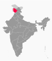 Example Map


.svg)
- Article(s)
- Jammu and Kashmir, Ladakh
- Request
- With recent changes going on in the political landscape of Kashmir, separate maps for the newly proposed union territories are needed per this discussion. A separate map for Ladakh (21-22) on the attached political map of India, and another map for the new Jammu and Kashmir (1-20), with color scheme and borders for both maps as in Example Map (the rest of the states appear to be a darker shade in Example Map). There also needs to be a border between Ladakh and the new Jammu and Kashmir in both maps. A response at the earliest would be appreciated. Thanks a bunch! DeluxeVegan (talk) 16:04, 7 August 2019 (UTC)
- Discussion
Water stress map
-
 Blankmap-world v6 for coloring

- Article(s)
- Water resources#global
- Water scarcity
- Request
- Make a new map called Water_stress_2019_WRI. Use blankmap_world-v6 for coloring up. Add a legend titled "Ratio of widthdrawals to supply", and with the same coloring as on this WRI page. Don't look at the maps at that page, rather skip to the table "National Water Stress Rankings" (these are 2019 aquaduct 3.0 data). This table is colored and shows what color to give each country, and what colors to use for the legend too. For the legend, show the colors and the texts:
- Low (<10%)
- Low to medium (10-20%)
- Medium to high (20-40%)
- High (40-80%)
- Extremely high (>80%)
I found a similar legend (older dataset, 2014) at [5] so I know those colors match that text in the legend.
For the description of this (wikimedia) map, you can mention https://www.wri.org/applications/aqueduct/country-rankings/ https://www.wri.org/blog/2019/08/17-countries-home-one-quarter-world-population-face-extremely-high-water-stress Also mention there that it's 2019 data (aqueduct 3.0). Genetics4good (talk) 09:51, 8 August 2019 (UTC)
- Discussion
Request for map/coordinates of El Salt
- Article(s)
- El Salt
- Request
- Y'all, I can do with some help from an expert. I'm trying to locate this place, but Google Maps offers nothing more than a now-closed restaurant in Alcoy. There is a 3-D picture in this article, and a description in this one. I really need at least coordinates, and a little map (based on whatever is on offer...) would be fantastic. It's a place of archaeological importance, cause it's got Neanderthal teeth and, you know, the oldest poop--which would make for a great DYK hook, of course. Added to my cartographic difficulties is the fact that I know more about writing about bacon than about archaeology, and I would love it if someone could lend me a hand... Thank you all in advance, Drmies (talk) 17:25, 9 August 2019 (UTC)
Balkan map labels

- Article(s)
- 29 pages on 19 wikis
- Request
- This map intentionally mixes details from c. 1914 and a map showing national boundaries today. Please replace "R. of Macedonia" with "North Macedonia" or "N. Macedonia", since the country recently changed its name. Nyttend backup (talk) 18:36, 9 August 2019 (UTC)
- Discussion
Eleanor cross
- Article(s)
- Eleanor cross
- Request
- This article includes a map (Data:Eleanor cross.map), which used to show a section of England running from Lincoln in the north to London in the south, with the locations of the 12 Eleanor crosses marked. I have no idea what has happened, but in the past few weeks the map as displayed in the article has shifted northwards, so that it is now centred on Lincoln, and only shows the northernmost 5 of the crosses in the bottom half. Can somebody please look at it and fix the problem? Thanks. GrindtXX (talk) 21:22, 9 August 2019 (UTC)
- Discussion
Mande Heartland (Medieval Mali)
- Article(s)
- Pre-imperial Mali (and related articles)
- Request
- A map of the Medieval Mande Heartland was published in Sunjata: A New Prose Version by David Conrad. This map however is probably copyrighted, so I was hoping someone with proper skills would be willing to do a new version for commons.--Plank (talk) 02:37, 10 August 2019 (UTC)
- Discussion