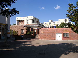
Noisiel station
Appearance
Noisiel Le Luzard | |||||||||||
|---|---|---|---|---|---|---|---|---|---|---|---|
 | |||||||||||
| General information | |||||||||||
| Location | Noisiel France | ||||||||||
| Coordinates | 48°50′36″N 2°37′00″E / 48.8433°N 2.6167°E | ||||||||||
| Operated by | RATP Group | ||||||||||
| Platforms | 2 side platforms | ||||||||||
| Tracks | 2 | ||||||||||
| Construction | |||||||||||
| Structure type | Below-grade | ||||||||||
| Bicycle facilities | Véligo parking station | ||||||||||
| Accessible | Yes, by request to staff[1] | ||||||||||
| Other information | |||||||||||
| Station code | 87758359 | ||||||||||
| Fare zone | 5 | ||||||||||
| History | |||||||||||
| Opened | 19 December 1980 | ||||||||||
| Passengers | |||||||||||
| 2019 | 3,016,034 | ||||||||||
| Services | |||||||||||
| |||||||||||
Noisiel station is a railway station on the Réseau Express Régional train network in Noisiel, Seine-et-Marne.
Description
[edit]History
[edit]Noisiel station opened on 19 December 1980, when RER line A was extended to Torcy, as well as Noisy–Champs and Lognes stations.[2]
Traffic
[edit]As of 2019[update], the estimated annual attendance by the RATP Group was 3,016,034 passengers.[3]
Transport
[edit]Train
[edit]The average waiting time for trains to Paris and to Marne-la-Vallée–Chessy is 10 minutes. But during peak hours most trains bound to Chessy do not stop at Noisiel, and passengers may take the trains that are bound to Torcy.
Bus connections
[edit]The station is served by several buses:
 RATP Bus network lines: 211 (to Vaires-sur-Marne and to Torcy), 213 (to Chelles via Noisy–Champs and to Lognes) and 220 (to Bry–sur-Marne and to Torcy) ;[4]
- Arlequin Bus network line: 10 (to Brie-Comte-Robert) ;[4][5]
- Sit'bus Bus network line: C (to Pontault-Combault) ;[4][6]
 Noctilien network night bus line: N130 (between Paris (Gare de Lyon) and Marne-la-Vallée–Chessy - Disneyland).[7]
References
[edit]- ^ "Plan pour les voyageurs en fauteuil roulant" [Map for travelers in wheelchairs] (PDF). Île-de-France Mobilités. 2023. Retrieved 27 December 2023.
- ^ "A propos du RER A". Le blog du RER A (in French). Retrieved 17 December 2015.
- ^ "Trafic annuel entrant par station du réseau ferré 2019". Open Data RATP (Data.Ratp.fr) (in French). RATP Group. Retrieved 8 August 2021.
- ^ a b c "Plan du réseau de bus à Marne-la-Vallée (Secteur n°11)" [Map of the RATP bus network in Marne-la-Vallée (Sector n° 11).] (PDF). Ratp.fr (Color map showing the names of bus stops and main streets.) (in French). RATP Group. May 2020. Retrieved 19 August 2020.
- ^ "Horaires ligne 10 (Arlequin) – Transdev Île-de-France". Transdev-idf.com (Timetable and route of line 10 of Arlequin Bus network.). Transdev. June 2020. Retrieved 20 August 2020.
- ^ "Horaires ligne C (Sit'bus) – Transdev Île-de-France". Transdev-idf.com (Timetable and route of line C of Sit'bus Bus network.). Transdev. June 2020. Retrieved 20 August 2020.
- ^ "Plan du réseau Noctilien (2017) - (Secteur : Paris & Sud-Est)" [Map of the night bus (Noctilien) network (2017) - (Sector: Paris and its south-eastern suburbs).] (PDF). Ratp.fr (Color map showing the names of the bus stops and the cities served.) (in French). RATP Group. April 2017. Retrieved 19 August 2020.
External links
[edit]![]() Media related to Gare de Noisiel at Wikimedia Commons
Media related to Gare de Noisiel at Wikimedia Commons
