Setauket, New York
Setauket-East Setauket, New York | |
|---|---|
| Setauket's local postal office Setauket's local postal office | |
 | |
| Country | United States |
| State | New York |
| County | Suffolk |
| Area | |
| • Total | 9.3 sq mi (24.0 km2) |
| • Land | 8.5 sq mi (21.9 km2) |
| • Water | 0.8 sq mi (2.1 km2) |
| Population (2000) | |
| • Total | 15,931 |
| • Density | 1,882.3/sq mi (726.8/km2) |
| Time zone | UTC-5 (Eastern (EST)) |
| • Summer (DST) | UTC-4 (EDT) |
| FIPS code | 36-66481 |
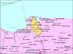
Setauket-East Setauket is a census-designated place (CDP) in Suffolk County, New York on the North Shore of Long Island. As of the United States 2000 Census, the CDP population was 15,931.
The CDP encompasses the hamlets of Setauket and East Setauket in the Town of Brookhaven.
Geography

Setauket-East Setauket is located at 40°55′48″N 73°6′7″W / 40.93000°N 73.10194°WInvalid arguments have been passed to the {{#coordinates:}} function (40.930007, -73.102081)Template:GR.
According to the United States Census Bureau, the CDP has a total area of 9.3 square miles (24.0 km²), of which, 8.5 square miles (21.9 km²) of it is land and 0.8 square miles (2.1 km²) of it (8.64%) is water.
The village of Setauket is located on the North Shore of Long Island in central Suffolk County. Part of Brookhaven's Three Village area, Setauket varies considerably as one travels north to south. In Setauket's Old Field there are wealthy waterfront estates on Long Island Sound, many from earlier decades. There is a New England style village green with a mill pond and park, a quaint post office, and the Caroline Church, built in 1729, and the Setauket Presbyterian Church established in 1660 . The Emma S. Clark Library, also on the Village Green is often considered one of the best on Long Island. During the American Revolutionary War, a small skirmish was fought on the village green, with some of the bullets embedded into the walls of Caroline Church.
The Jerusalem Patriarchate in America is headquartered in Setauket.
The "Setaukets" historically referred to the area between Stony Brook and Port Jefferson Harbors, included what are now called Head of the Harbor and St James (now part of Smithtown and not usually included as part of the Three Villages), Stony Brook (Old Stony Brook and South Stony Brook, the latter is where the State University of New York at Stony Brook is located), South Setauket (not to be confused with parts of Centereach that are referred to as such), Strong's Neck, East Setauket, and Port Jefferson (formerly known as Drowned Meadow, renamed at the behest one of its famous residents PT Barnum).
South of 25A, Setauket becomes more varied with quaint colonial style houses mixing with light industrial areas and Levitt-built houses near NY Route 347 (Nesconset Highway).
The three major east-west roads are Route 25A, Route 347 and Sheep Pasture Road. Sheep Pasture Road is split among Upper and Lower Sheep Pasture Roads for a short stretch between Gnarled Hollow Road and Pond Path. Setauket is accessible from the Long Island Expressway via EXIT 62.
The ZIP Code for Setauket is 11733.
Almost all of the commercial establishments in Setauket are concentrated in three areas. One is on Route 25A, another is on Belle Meade Road (formerly called Terminal Road after the oil terminal), and on Route 347/Nesconset Highway. There are a large number of medical and professional offices on Belle Meade along with other stores that service them. The rest of Setauket is residential except for schools. There is a smattering of shops and factories spread out over Setauket set up before modern zoning rules went into effect. There are a couple of them on Gnarled Hollow road and a few on Comsewogue road.
Demographics

As of the censusTemplate:GR of 2000, there were 15,931 people, 5,521 households, and 4,289 families residing in the CDP. The population density was 1,882.3 per square mile (727.1/km²). There were 5,632 housing units at an average density of 665.4/sq mi (257.0/km²). The racial makeup of the CDP was 87.76% White, 1.27% African American, 0.17% Native American, 8.80% Asian, 0.04% Pacific Islander, 0.61% from other races, and 1.35% from two or more races. Hispanic or Latino of any race were 3.43% of the population.
There were 5,521 households out of which 39.2% had children under the age of 18 living with them, 68.6% were married couples living together, 6.8% had a female householder with no husband present, and 22.3% were non-families. 17.2% of all households were made up of individuals and 4.7% had someone living alone who was 65 years of age or older. The average household size was 2.88 and the average family size was 3.26.
In the CDP the population was spread out with 26.9% under the age of 18, 7.3% from 18 to 24, 29.3% from 25 to 44, 27.2% from 45 to 64, and 9.4% who were 65 years of age or older. The median age was 37 years. For every 100 females there were 96.7 males. For every 100 females age 18 and over, there were 94.5 males.
The median income for a household in the CDP was $86,986, and the median income for a family was $102,472. Males had a median income of $70,276 versus $41,281 for females. The per capita income for the CDP was $37,736. About 1.4% of families and 2.0% of the population were below the poverty line, including .8% of those under age 18 and 0.3% of those age 65 or over.
Local history
The region was first settled by Europeans in the 1650s.
During the American Revolutionary War, the Culper Spy Ring headed by Benjamin Tallmadge passed information about British troop movements gathered in New York City to George Washington. The 1777 Battle of Setauket was fought here.
Education

The Three Village Central School district serves the Setauket community.
- Ward Melville High School - Renowned nationwide for the InSTAR science research program, which produces a disproportionately high number of Intel Semifinalists for the Intel Science Talent Search. Perhaps more noted in the region for their Lacrosse team.
- Gelinas Junior High School - Named after Paul J. Gelinas, who was the first district principal.
- Murphy Junior High School - Named after Robert C. Murphy, a local naturalist.
- William Sydney Mount Elementary School - Named after a local 19th century artist known for his renditions of local, everyday life.
- Setauket Elementary School
- Nassakeag Elementary School
- Minnesauke Elementary School - Setauket Indian word for "Little Neck", the name for what is now known as Strong's Neck.
- Arrowhead Elementary School
- Christian Avenue School - Original buildings dating back from earlier part of the century. Used for Kindergarten and 1st grade before closing in late 1970s. Demolished and redeveloped as McMansions in the 1990s.
- North Country School - Former elementary school, closed in 1980s. Some of the districts administrative offices are located there as well as rented to BOCES.
- Stony Brook School (Private) - local urban myth (which is incorrect) is that this is the very school J. D. Salinger attended and wrote about in Catcher in the Rye.
- Emma S. Clark Library
- State University of New York at Stony Brook
- Torah Tots, Chabad Hebrew school
Food
Most of the food service establishments including restaurants in Setauket are on Route 25A, which is also the road with most of the commercial establishments in Setauket. Route 25A has more numerous but smaller shops while Route 347 has fewer but larger shops. Most of the restaurants on Route 347 are chain restaurants but most of the restaurants along Route 25A are not part of a chain. Major grocery stores also have deli counters.
Attractions

There are two historic churches: Caroline Church (built 1730) and Setauket Presbyterian Church (originally built 1674), both built on Setauket Greens area. Up the road near these churches is the Greek Orthodox Monastery of the Holy Cross. Other attractions include the Village Green, the Emma S. Clark Memorial Library, Three Village Garden Club Arboretum and Nature Preserve, historic Setauket Post Office, Setauket Neighborhood House and the Setauket Mill Pond. All the above attractions easy walking distance of each other (all within a thousand feet), photogenic (popular with wedding photographers) and worth visiting. The Setauket Mill Pond has a resident population of ducks, geese and swans, is stream fed and is stocked with bass. Fishing in the Mill Pond requires a fresh water NY license.
The Thompson House (91 North Country Road at Old Town Road) is another registered historic place in Setauket
The Long Island Museum features one of the largest collection of horse-drawn carriages in the world, as well as paintings by William Sydney Mount. It is also the host of an annual folk festival.
Regional newspapers
- Newsday (Daily)
- Three Village Times Herald (weekly)
- Suffolk Life (weekly)
- The Statesman (Stony Brook University)
- Stony Brook Press (Stony Brook University)
Notable residents
Some notable residents of the Setaukets ):
- Bud Abbott, comedian (1897-1974)
- Ray Anderson (jazz musician)
- Mick Foley, professional wrestler.[1]
- John Fugelsang, actor/writer
- Amy Goodman, radio journalist
- Frederick Lenz "Rama" religious leader and guru
- Ward Melville, businessman and local philanthropist (1887-1977)
- William Sydney Mount, painter (1787-1869)
- Robert Cushman Murphy, naturalist (1887-1973)
- James Harris Simons, cryptanalyst, mathematician, hedge fund founder, and philanthropist
- Dee Snider, radio personality and singer from Twisted Sister
- Angel Viloria, merengue musician
- Kevin James, comedian/actor
- Todd Sauerbrun, NFL punter.[2]
Various musical groups have been associated with the Setaukets, including
Gallery
-
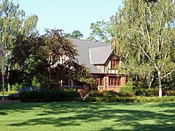
The Setauket Elementary School
References
- ^ Smith, Dinitia. "A Wrestler Who Prefers the Pen to the Pin", The New York Times, May 22, 2001. Accessed October 23, 2007. "Have a Nice Day covers his childhood in Setauket, N.Y., on Long Island. "
- ^ "COLLEGE FOOTBALL; Booming Success For Losers", The New York Times, August 29, 1994. Accessed October 24, 2007. "It was a great day for the 6-foot, 200-pound kicker from Setauket, L.I., who averaged 60.1 yards in his nine attempts."

