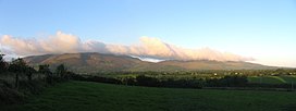
Comeragh Mountains
Appearance
| Comeragh Mountains | |
|---|---|
| Na Comaraigh | |
 Comeragh Mountains | |
| Highest point | |
| Elevation | 792 m (2,598 ft) |
| Prominence | 625 m (2,051 ft) |
| Geography | |
 | |
| Location | County Waterford, |

The Comeragh Mountains (Na Comaraigh in Irish) are a glaciated mountain range situated in the south east of Ireland in County Waterford. They are located between the town of Clonmel on the County Tipperary border and the villages of Kilrossanty and Kilmacthomas in County Waterford.
The twelve mountains which form the Comeragh Mountains are very popular for mountain climbers and hikers. The highest peak is Fauscoum at 792 m (2,598 ft).
References
Waterford's Mountains on Facebook and Twitter for all the latest information,photos and news on the Comeragh,Monavullagh and Knockmealdown mountains= https://www.facebook.com/pages/Waterfords-Mountains/133275260073399 https://twitter.com/#!/WaterfordsMount

