
Lake Sevan
| Lake Sevan | |
|---|---|
| Coordinates | 40°19′N 45°21′E / 40.317°N 45.350°E |
| Primary inflows | 28 rivers and streams |
| Primary outflows | evaporation (90%), Hrazdan |
| Basin countries | Armenia |
| Max. length | 78 km (2005) |
| Max. width | 56 km (2005) |
| Surface area | 940 km² (2005) 1236 km² (2002) [1] 1416 km² (1933)[1] |
| Water volume | 32.921 km³ (2002) 58.5 km³ (1933)[1] |
| Surface elevation | 1900.01 m (2010) 1896.32 (2002) 1916.2 m (1933)[1] |
| Settlements | |
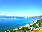
Lake Sevan (Armenian: Սևանա լիճ Sevana lich) is the largest lake in Armenia and the Caucasus region. It is one of the largest fresh-water high-altitude lakes in the world.
Lake Sevan is situated in the central part of the Republic of Armenia, inside the Gegharkunik Province, at the altitude of 1,900m above sea level. The total surface area of its basin is about 5,000 km2, the lake itself is 940 km2, and the volume is 34.0 bln cubic metres. It is fed by 28 rivers and streams. Only 10% of the outgoing water is drained by the Hrazdan (Razdan) river, while the remaining 90% evaporates.
Before human intervention dramatically changed the Lake Sevan ecosystem, the lake was 95 metres deep, covered an area of 1,360 km² (5% of Armenia's entire area), had a volume of 58 km³ and a perimeter of 260 km. The lake surface was at an altitude of 1,916 m above sea level.
Along with Lake Van and Lake Urmia, Sevan was considered one of the three great lakes of the historical Armenian Kingdom, collectively referred to as the Seas of Armenia; it is the only one within the boundaries of today's Republic of Armenia. The Sevanavank peninsula (formerly an island) is the historic area of the lake at its northern shores.
Names

Historical names of the lake are Gegharkuni (Armenian: Գեղարքունի), Sea of Gegham (Armenian: Գեղամա ծով Geghama tsov), Lychnitis (Greek and Latin), and (Turkic: Gökçe or Göyçə).[2][3] On Russian map of 1902 the name of the lake is given as "Gokce or Sevanga".[4] The name Sevan literally means "Black Van" referring to Lake Van. It is said that long ago, Armenians came from the areas around Lake Van to Lake Sevan. They saw that the lake was dark and almost black yet reminded them of Van, therefore the lake was called Sevan.[5][6] The Old Georgian name for the lake drew from the name of its old inhabitants (i.e. before the fall of Urartu), the Èrs- it was called "Lake Ereta" by Leonti Mroveli in his Georgian Chronicles.[7]
For a long time, the word "Sevan" was known to be connected with the monastery in the small island of the lake Sevan called "Sev Vank" ("Black Monastery") built with black tuff. And this was known to be the etymology of name Sevan. But it was obviously wrong, because the word "Sevan" was older than the monastery itself. Finally, the etymology of word "Sevan" was found in Teyseba (the cuneiform inscription by Rusa I (730—714 B.C.)). This inscription was a "birth certificate" of the term "Sevan". It was mentioned as "Suinia" or "Tsuinia". Thus, the etymology of "Sevan" is similar to Yerevan's etymology. It was named after simple geographical names, as water, river, lake, mount, etc. Later scientists found that "Suinia" or "Tsuinia" means "lake" or "basin" in Urartian.
Intervention

In 1910 Soukias Manasserian, one of the civil engineers behind the interventions that caused the Aral Sea disaster,[8] published a study Evaporating billions and stagnation of the Russian Capital, which suggested the lowering of the lake's surface to 45 metres and the use of the water for irrigation and hydroelectricity.
In Joseph Stalin's era the plan was slightly modified: the water level would be reduced by 55 metres (5 metres more than suggested by Manasserian), the perimeter would shrink to 80 km and the volume to only 5 km³. Nut and oak trees would be planted on newly acquired land, and introducing some trout species into the remainder of the lake would increase fishery production tenfold.
The Armenian Supreme Soviet approved the plan without consulting the local people, and major work started in 1933. The river bed of the Hrazdan was deepened, and construction of a tunnel 40 metres below the original water level was begun. The work was delayed due to World War II and was only finished in 1949. The water level then began to fall by more than one metre per year.
As a result of these activities, the level of the lake fell by 19.01m, from its original of 1,915.9m. The lake is now 1,896.86 metres high; the volume has declined from 58.5 billion cubic meters to about 34.0, and the surface area has shrunk from 1,416.2 km2 to 1,238.1 km2.

An ecological disaster like in the Aral Sea was avoided when the Stalinist era ended in 1956 and the project and its consequences were reviewed thoroughly. As there were difficulties with planting oaks and nut trees, and with fishery, the Sevan Committee was established with the mission "to raise the level as much as possible". Hydro-electric power stations on the Hrazdan would be replaced with thermal power stations. In 1962 the water level stabilized at 18 metres below the original level, but two years later the lake started to "bloom" due to eutrophic algae.
In 1981, a 49.3 km tunnel was constructed, diverting water from the Arpa river (from a reservoir near Kechut) to the lake near Artsvanist. The water level in the lake rose only 1.5 metres, so another 21.7 km tunnel was begun from Vorotan River (further south from Kechut). Eighteen kilometers of this tunnel were completed before the collapse of the Soviet Union, but in 1988 Azerbaijan imposed an economic blockade on Armenia due to the Nagorno-Karabakh conflict, and the work had to be stopped.
The Armenian government completed the Vorotan tunnel in 2004, but water has not yet begun to flow into the lake. The level stabilized at 20 metres below the original, and the lake's area is now 940 km².
On March 2, 2012 the chairman of the presidential committee on Lake Sevan issues stated that in line with the laws adopted since 2001, the water level of the lake had risen by 380 cm and the lake stands today at 1900.19m high.[9]
Negative effects
During the past decades, the ecological condition of Lake Sevan has undergone tangible changes and vast degradation due to the following reasons: a) reduced water level, b) increased eutrophication c) detrimental impact of human activity on the biological diversity of the lake.
Lowering of the water level had a variety of negative consequences. The biological mass of macrophyte plants fell, resulting in lack of adaptability of the plants changes, namely the weeding and pollution of the water in the newly emerged waterless area of the shore, as a result of growing erosion of this area. Dangerous reduction of Hypolimnion is another problem. Hypolimnion is the internal section of Sevan, in which the organic substances alochtone and autochtone mineralize. If this section is well developed (for example, in Lake Geneva it is 85% of the whole mass) then mineralization process is active, without discarding the oxygen, dissolved in water.
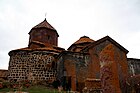
The Island Monastery

Originally made from three churches, the monastery was built on an island. Receding waters in the mid-twentieth century created the current peninsula. The island was uninhabited until the end of the eighth century A.D., when monks built a chapel and a group of cells. The monastery was founded in 874 by King Ashot I, the first king of the Bagratid kingdom, and his daughter Mariam. Two churches remain, St. Arakelots and Astvatsatsin. The island monastery was, according to historians of the time, used both for worship and pilgrimage, and as a place of exile for Armenian noblemen who had fallen into disgrace. It also was the residence and headquarters for Ashot I, from which he led a battle against invading Arabs beginning in 859.
During the battles monks and clergy fought alongside the army to defeat the Arabs, but repeated Arab and Ottoman invasions continued. The monks on the island continuously led battles to protect the monastery, and such was the life in and around the monastery for almost 500 years until the Persians and the Ottomans divided the Armenian kingdom. The monks in Gegham-kiunik specialized in medicine, and some of their natural cures are still used, based on herbs that grow in the wild around the lake. The monastery continued to function until the 20th century; the last monk left in 1930. Today the monastery is maintained by the Church, which maintains a summer retreat for seminarians on the peninsula.
Beaches

There are numerous beaches along the entire lake shore. The most popular of them is a 2.5 kilometre stretch on the northern shore, extending northwest from the peninsula. Resorts include Harsnaqar Hotel, Best Western Bohemian Resort, and numerous smaller facilities. Activities include swimming, sunbathing, jet skiing, windsurfing, and sailing. The area also includes numerous campgrounds and picnic areas for daytime use.
A less developed beach destination stretches along the eastern shore from Tsovagyugh to Shorzha, with numerous small cabins at Shorzha. The Avan Marak Tsapatagh Hotel, a Tufenkian Heritage Hotel, is a luxury resort on the undeveloped southeastern shore of the lake near Tsapatagh.

Sites of interest

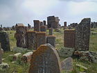
The most famous cultural monument is the Sevanavank monastery near the town of Sevan at the northwestern shore. Initially the monastery was located on an island, but the fall of the water level turned it into a peninsula. Another monastery at the western shore is Hayravank Monastery, and further south, in the village of Noraduz, there is a field of khachkars, a cemetery with approximately 900 khachkars of different styles. Additional khachkars are found at Nerk'in Getashen on the south coast. When the water level fell, many archaeological artifacts were found, 2000 years of age and older (some as old as the early Bronze Age). Most of them are now displayed in Yerevan.
Fauna
- Fish
Sevan trout (Salmo ischchan) was an endemic species of the lake, but it is endangered as some competitors were introduced into the lake, including common whitefish (Coregonus lavaretus) from Lake Ladoga, goldfish (Carrasius auratus), and crayfish (Astacus leptodactylus). If the Sevan trout is likely to become extinct in its "home" lake, it seems that it will survive in Issyk-Kul Lake (Kyrgyzstan) where it was introduced in the 1970s.
Due to anthropogenic impact, changes have occurred in all the biologycal components of the lake, including bacteria, benthos, and of course fish. Thus, the benthic mass increased 10-fold in 1940, due to oligochetes and chrinomices. Today, the former prevail and multiply the oxygen-rich residue at the bottom of the Lake.
The bojak and winter bakhtak species of the Sevan-endemic trout have already disappeared. The summer bakhtak occurs rarely; the gegharkuni is still capable of reproducing naturally. In 1980s, the quantity of Sevan koghak significantly decreased. There are numerous reasons for this:
- The level of the water lowered, the patches of rivers changed, the trout (gegharkuni and Aestivalis species) lost its natural spаwning place. Changes in the areas near the shore (mossing, disappearance of macrophyte plants) also had a negative impact on the trout lays. The trout spawns only in certain areas, where there is oxygen-rich underground water at the depth of 25–30 meters.
- Deoxidization of the bottom is extremely detrimental for salmon, which are used to more than 4 mg O2 per litre.
- In the last 10 years, poaching rapidly increased, which significantly reduced the amount of fish in the lake.
- Other species
The lake is an important breeding ground for the Armenian Gull (Larus armenicus) with about 4,000–5,000 pairs. Other birds which visit the lake include Bewick's swan (Cygnus columbianus), lesser white-fronted goose (Anser erythropus), red-crested pochard (Netta rufina), ferruginous duck (Aythya nyroca) and great black-headed gull (Larus ichthyaetus). The mouflon are suffering a great population decline due to poaching and habitat loss. The Sevan trout, which made up thirty percent of the fish in Lake Sevan, have virtually disappeared. Another endangered visitor to the lake is the Armenian leopard or panther (Panthera pardus tullianus).
Gallery
- Lake Sevan
-
 View from Sevan peninsula
 -
 Beach on Sevan peninsula
 -
 Swimming beaches
 -
 Sevan city beach
 -
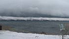 Sevan in winter
 -

-
 Akhtamar's statue
 -
 Hayravank Monastery complex
 -
 Noraduz cemetery near Gavar, the largest extant khachkar cemetery
 -
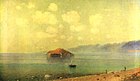 Lake Sevan at sunrise by Gevorg Bashinjaghyan (1894, Museum of Oriental Art, Moscow)


References
- ^ a b c d Lake Sevan: Experience and Lessons Learned Brief
- ^ William Edward David Allen, Paul Muratoff, Caucasian Battlefields: A History of the Wars on the Turco-Caucasian Border 1828-1921, Cambridge University Press, 2011, ISBN 978-1-108-01335-2, p. 475.
- ^ John E. Woods, The Aqquyunlu: Clan, Confederation, Empire, University of Utah Press, 1999, ISBN 978-0-87480-565-9, p. 178.
- ^ Azerbaijani khanate of Karabakh in the map of Caucasus in 1809-1817 years
- ^ René Grousset. The Empire of the Steppes: A History of Central Asia, Rutgers University Press, 1970, p. 348, ISBN 0-8135-1304-9
- ^ Jacques Kayaloff. The Battle of Sardarabad, Mouton, 1973, p. 211
- ^ Jaimoukha, Amjad. Chechens. Page 30.
- ^ Holding, Nicholas (2006). Armenia: with Nagorno Karabagh. Bradt Travel Guides. p. 133. ISBN 978-1-84162-163-0.
- ^ [1]
See also
- Sevanavank – Island monastery in lake sevan.
- Sevan National Park
- Cleaning works continue in Sevan Lake shore
- www.sevan.am all about the lake
- Lake Sevan – Armeniapedia article with information and photos
- Rediscovering Armenia US Embassy;
- Tectonic impact on Lake Sevan environment
- Lake Sevan on worldlakes.org
- Photos at Armenia Photos.info
- National Assessment Report for the World Summit of Sustainable Development Johannesburg 2002
- Kamsar Avetisyan, ՀԱՅՐԵՆԱԳԻՏԱԿԱՆ ԷՏՅՈՒԴՆԵՐ – ՍԵՎԱՆԻ ԱՎԱԶԱՆ, "Sovetakan grogh", Yerevan, 1979
