
Tumen River
42°25′47″N 130°36′41″E / 42.42972°N 130.61139°E
| Tumen River | |||||||||
|---|---|---|---|---|---|---|---|---|---|
 Location of the Tumen River | |||||||||
| Chinese name | |||||||||
| Traditional Chinese | 圖們江 | ||||||||
| Simplified Chinese | 图们江 | ||||||||
| |||||||||
| Korean name | |||||||||
| Chosŏn'gŭl | 두만강 | ||||||||
| Hancha | 豆滿江 | ||||||||
| |||||||||
| Mongolian name | |||||||||
| Mongolian Cyrillic | [Түмэн гол, Tümen gol] Error: {{Lang}}: text has italic markup (help) | ||||||||
| Manchu name | |||||||||
| Manchu script | (Tumen ula) | ||||||||
| Russian name | |||||||||
| Russian | [Туманная река, Tumannaya Reka] Error: {{Lang}}: text has italic markup (help) | ||||||||
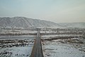
The Tumen River is a 521 km-long river that serves as part of the boundary between China, North Korea, and Russia, rising in Mount Baekdu and flowing into the Sea of Japan.
The river flows in northeast Asia, on the border between China and North Korea in its upper reaches, and between North Korea and Russia in its last 17 kilometers (11 mi) before entering the Sea of Japan. The river forms much of the southern border of Jilin Province in Northeast China and the northern borders of North Korea's North Hamgyong and Yanggang provinces. Baekdu Mountain on the Chinese-North Korean border is the source of the river,[1] as well as of the Yalu River (which forms the western portion of the border of North Korea and China). It also is very close to the Yellow river in north korea
The name of the river comes from the Mongolian word tümen, meaning "ten thousand" or a myriad. This river is badly polluted by the nearby factories of North Korea and China; however, it still remains a major tourist attraction in the area. In Tumen, Jilin, China, a riverfront promenade has restaurants where patrons can gaze across the river into North Korea.[1] Russian name of the river is Tumannaya, literally meaning foggy.
In 1995, the People's Republic of China, Mongolia, Russia, and South Korea, signed three agreements to create the Tumen River Economic Development Area. [2]
Important cities on the river are Hoeryong, Namyang and Onsong in North Korea, Tumen and Nanping in China.
Refugee crossing
The Tumen has been used for years by North Korean refugees defecting across the Chinese border. Most refugees from North Korea during the 1990s famine crossed over the Tumen River, and most recent refugees have also used it.[citation needed]
Although the Tumen is heavily patrolled by armed guards of North Korea, the river is considered the preferred way to cross into China because, unlike the swift, deep and broad Yalu River which runs along most of the border between the two countries, the Tumen is shallow and narrow.[1] "It is easily crossed in spots on foot or by swimming," according to a 2006 article in The New York Times.[1]
Defectors who wish to cross the Tumen often ignore its pollutants and dangerous border patrol, and spend weeks if not months or years waiting for the perfect opportunity to cross.
- "Long, desolate stretches of the Chinese-North Korean border are not patrolled at all," according to a New York Times article.[1]
Refugees seldom cross the Tumen into Russia. This is because Russia's short stretch of the river is far better patrolled than China's stretch. In addition, there is no sizable ethnic Korean community in Russia to receive support from, as opposed to China, which has a larger Korean population. Finally, China is far less inclined to deport illegal North Korean aliens back than Russia is. (see also North Koreans in Russia).[1]
The humanitarian crisis along the Tumen River was dramatized in the award-winning 2009 dramatic feature-length film, Dooman River.
-
 Bridge of Tumen River, built in 1941
 -
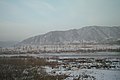
 North Korea is on the other side of the Tumen River
 -


Notes
- ^ a b c d e f [1] Onishi, Norimitsu, "Tension, Desperation: The China-North Korean Border", October 22, 2006. Much of the information cited in this footnote comes from the captions to the large illustrated map published with the newspaper article and available online with it.
- ^ HighBeam Research - Article: Accord on Tumen River Area Development to Be Signed.