Bayencourt
- Asturianu
- 閩南語 / Bân-lâm-gú
- Català
- Cebuano
- Deutsch
- Español
- Euskara
- فارسی
- Français
- Հայերեն
- Italiano
- Kurdî
- Latina
- Magyar
- Malagasy
- Bahasa Melayu
- Nederlands
- Нохчийн
- Occitan
- Oʻzbekcha / ўзбекча
- Picard
- Piemontèis
- Polski
- Português
- Română
- Shqip
- Simple English
- Slovenčina
- Српски / srpski
- Srpskohrvatski / српскохрватски
- Svenska
- Татарча / tatarça
- Basa Ugi
- Українська
- Vèneto
- Tiếng Việt
- Winaray
- 中文
From Wikipedia, the free encyclopedia
This is the current revision of this page, as edited by Markussep (talk | contribs) at 14:52, 31 August 2022. The present address (URL) is a permanent link to this version.
(diff) ← Previous revision | Latest revision (diff) | Newer revision → (diff)
Commune in Hauts-de-France, France
Bayencourt | |
|---|---|
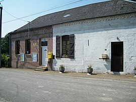
 The town hall of Bayencourt | |
| Coordinates: 50°07′57″N 2°34′26″E / 50.1325°N 2.574°E / 50.1325; 2.574 | |
| Country | France |
| Region | Hauts-de-France |
| Department | Somme |
| Arrondissement | Péronne |
| Canton | Albert |
| Intercommunality | CC du Pays du Coquelicot |
| Government | |
| • Mayor (2020–2026) | Virginie Adamczyk[1] |
| Area 1 | 1.84 km2 (0.71 sq mi) |
| Population (2021)[2] | 74 |
| • Density | 40/km2 (100/sq mi) |
| Time zone | UTC+01:00 (CET) |
| • Summer (DST) | UTC+02:00 (CEST) |
| INSEE/Postal code | 80057 /80560 |
| Elevation | 110–157 m (361–515 ft) (avg. 200 m or 660 ft) |
| 1 French Land Register data, which excludes lakes, ponds, glaciers > 1 km2 (0.386 sq mi or 247 acres) and river estuaries. | |
Bayencourt is a commune in the Somme department in Hauts-de-France in northern France.
Geography[edit]
A very small village, situated on the junction of the D23 and D129 roads, about halfway between Arras and Amiens.
Population[edit]
| Year | Pop. | ±% p.a. |
|---|---|---|
| 1968 | 76 | — |
| 1975 | 70 | −1.17% |
| 1982 | 72 | +0.40% |
| 1990 | 64 | −1.46% |
| 1999 | 73 | +1.47% |
| 2007 | 74 | +0.17% |
| 2012 | 83 | +2.32% |
| 2017 | 79 | −0.98% |
| Source: INSEE[3] | ||
See also[edit]
References[edit]
- ^ "Répertoire national des élus: les maires". data.gouv.fr, Plateforme ouverte des données publiques françaises (in French). 2 December 2020.
- ^ "Populations légales 2021". The National Institute of Statistics and Economic Studies. 28 December 2023.
- ^ Population en historique depuis 1968, INSEE
Wikimedia Commons has media related to Bayencourt.
| Authority control databases: National |
|---|
This Arrondissement of Péronne geographical article is a stub. You can help Wikipedia by expanding it. |
Hidden categories:
- CS1 French-language sources (fr)
- Articles with short description
- Short description is different from Wikidata
- Coordinates on Wikidata
- Pages using infobox settlement with image map1 but not image map
- Commons category link is on Wikidata
- Articles with BNF identifiers
- Articles with BNFdata identifiers
- All stub articles
- Pages using the Kartographer extension


