
Lehigh Canal
This article has multiple issues. Please help improve it or discuss these issues on the talk page. (Learn how and when to remove these template messages)
|
Lehigh Canal | |
 The Lehigh Canal as seen from Guard Lock 8 & Lockhouse, Island Park Road, Glendon, Northampton County, Pennsylvania | |
 Lower division of the Lehigh Canal, from Jim Thorpe, Pennsylvania to Easton, Pennsylvania | |
| Location | Lehigh River Upper: Nesquehoning, Pennsylvania to White Haven, Pennsylvania Lower: Mauch Chunk (Jim Thorpe) to Delaware River at Easton, Pennsylvania |
|---|---|
| Coordinates | 40°46′09″N 75°36′13″W / 40.76917°N 75.60361°W |
| Built | 1818-1821; 24-27 upper: 1838-1843, Upper ruined & abandoned: 1862 |
| Architect | Canvass White, Josiah White |
| Architectural style | Fitted stone, iron and wood |
| NRHP reference No. | 78002437, 78002439, 79002179, 79002307, 80003553[1] |
| Added to NRHP | Earliest October 2, 1978 |
The Lehigh Canal or the Lehigh Navigation Canal is a 'navigation' type canal. The canal begins at the mouth of Nesquahoning Creek on the Lehigh river in Eastern Pennsylvania. It was constructed in two parts, a lower and an upper section built over a span of twenty years beginning in 1818. Its sections were engineered to bypass rapids in the Lehigh River. The canal moved anthracite coal from the area around the city of Mauch Chunk, now call Jim Thorpe, Pennsylvania to the cities of the East Coast of the United States. The canal was eventually 72 miles (116 km) long.
At its terminus, other entities would scramble to build canals and railroads to distribute the 'fuel choice of the day' to the Eastern Seaboard of America and to ocean going ships.
Anthracite coal would help solve the nation's first energy crises as deforestation raised firewood and fuel prices and incurred ever increasing transportation costs, but also make iron easier to make and more plentiful. This would help revolutionize the making of materials, machinery and hundreds of cumulative innovations as White and his associates brought anthracite pig iron smelting into being and made the Lehigh Valley a major iron production center —the leading production region in iron and steel production for decades.[2]
Politics and era

The lower navigation began as a humble collection of removed stone obstructions, low piled rock dams with a system of wooden "Bear Trap Locks" invented by Lehigh Navigation Company managing partner, Josiah White who debugged scale models of the new lock design on Mauch Chunk Creek.[a] would leverage the canal into the American Industrial Revolution, that for 111 years shipped the fuel feeding the foundries, forges, manufacturies, and steel mills of Eastern Pennsylvania, New Jersey, and much of New York, New England, and the world. It started with the need for energy by White and partner Erskine Hazard who operated a wire mill, foundry, and nail factory at the Falls of the Schuylkill. Having learned the secret to burning anthracite during the British blockades in 1814, White and Hazard joined a number of Philadelphia luminaries in subscribing to a joint stock venture to build the Schuylkill Canal, but quarreled with the others on the board of managers, who did not favor a rapid development. Investigating options, they learned the managers of the Lehigh Coal Mine Company were willing to option their rights, disgusted with their long term inability to make a profit bringing Anthracite nearly 110 miles from Pisgah Ridge. A group, the Lehigh Navigation Company was holding a charter to improve the navigability of the Lehigh River, but had little to show for repeated expenditures and their charter was due to expire in 1817. White and Hazard made their proposal, which specified improvements for only down river navigation, and in March 1818 received a charter effectively giving the company ownership of the Lehigh to do with as they would. It had one fall-back provision — at some time the legislature might require the improvements be made to enable two way navigation.[2]
The plan, says Josiah White, who was its originator, was to "improve the navigation of the river by contracting the channels funnel fashion, to bring the whole flow of water at each of the falls to as narrow a compass as the law would allow, by throwing up the round river stones into low walls not higher than we wanted to raise the water for the required depth of fifteen or eighteen inches by the natural flow, to make artificial freshets to supply the deficiency; that is, by making ponds of water of as many acres as we could get, and letting it off periodically, say once in three days. I supposed we could gather water enough to secure the required quantity, and thus secure a regular descending navigation. The plan for locks and gates for letting out the freshet in a proper manner was left for the present to be devised in due time if found necessary.
— Fredrick Brenckman, History of Carbon County (1884)[5]
The Lower Canal
- By some called "The Stone Coal Turnpike"[6]
The lower canal (46.5 miles (74.8 km)) was built by the Lehigh Navigation Company as a coal toll road to service the Anthracite appetite of Eastern seaboard cities ahead of schedule, between 1818-1820 (down traffic only), and then gradually rebuilt (with locks fully supporting two way traffic) 1827-1829 by the Lehigh Coal & Navigation Company and continued in operation as a key transportation canal until the 1931. The lower canal connected the Eastern part of the Southern Coal Region to the Delaware River basin—mainly the Panther Creek Valley, Nesquehoning Creek Valley, and coal mines along the Beaver Meadows, PA-Black Creek, connecting via Penn Haven Junction to the canal head at Mauch Chunk (now Jim Thorpe, PA).
The lower canal began below Packers Dam a wing wall projecting out into the upper pool to create a slack water condition next to the coal loading docks, at having the same level as top of the first guard Dam referred to as Dam 1 (just down stream of Broadway opposite Flagstaff Hill and the cross-canal summit Bear Mountain for which Mauch Chunk was named. The 44 Lift locks begin with Lock 1 at the dam, which was also a weighing lock using a clever platform which lifted a barge and weighed the boat and load quite accurately. Each non-LC&NC barge on the canal had to be record and empty weights were subtracted and tolls assessed by the ton per mile traveled, like fares on any toll road. Most of the 44 locks on to descent to Easton, PA were spillway variations of White's Bear Trap lock, which when tipped or triggered released several acre-feet allowing an artificial wave front to raise the water level as the canal boat sank down river. using a specially designed canal boat capable of making the one-way trip on the River as well.[b] It was used to carry anthracite gathered to the central Lehigh Valley to the urban markets of the northeast, especially Philadelphia, Pennsylvania, Trenton, New Jersey, and Wilmington, Delaware, but supported new growth industries in Bristol, PA, Allentown and Bethlehem, and through the Morris Canal and Delaware and Raritan Canal and a number of railways, supported energy needs of the country. The privately funded canal was joined as part of the Pennsylvania Canal System, a complex system of canals and tow paths—and eventually railroads. The canal was last used to carry cargoes in 1942 and thereafter LC&N Co. let nature's ravages have their gradual and inevitable way. The LC&N Co. was sold back to Pennsylvania for preservation and recreational use in the 1964.
Today, many parts of the canal or railroads later constructed to flank it, have been converted to the Delaware and Lehigh National Heritage Corridor (known colloquially as the 'Delaware & Lehigh Trail', the 'D & L Trail'), a multi-use rail trail.
History
There are few rivers, the navigation of which has been more the subject of legislation than that of the Lehigh. The river was first declared a public highway on the fourteenth of March, 1761, and an Act, supplementary to this, was passed in 1771. Acts, conferring corporate privileges on the "Lehigh Navigation Company," were passed February 27th, 1798, March 7th, 1810, March 22d, 1814, March 19th, 1816, and March 24th, 1817; but although under these, "considerable sums were expended", nothing of importance had been accomplished towards the desired end down to the year 1818. [and the charters provision were let lapse, opening the way for White & Hazard to acquire the rights.]
On March 20th, 1818, their new Lehigh Navigation Company was virtually given ownership of the Lehigh to do as it would, with but one restriction. [Specifically, At some time in the future, the state might exercise its right to require they make the canal a two way water transport highway with appropriate locks and dams.][7]
The Lehigh Coal Mine Company
The Lehigh Coal Mine Company (LCMC) was founded in 1792, a few months after Anthracite coal was discovered at Sharpe Mountain, a peak of the Pisgah Ridge near to the location that became Summit Hill, Pennsylvania,[c] and its principals would secure rights to over 10,000 acres before the Lehigh Canal was created. Where that enterprise found it fairly easy to find and mine coal from a pit along the mountainside,[d] but the mine output needed laboriously loaded into sacks then onto pack animals which had to carry the coal a minimum of nine miles to the Lehigh shores. There, the company had to build disposable skiffs called arks, cutting down, saw milling, and using local stands of timber, which then needed manned when waters were ample enough by stout hearted men which had to brave and survive running the various rapids along the lower Lehigh River. Despite many politically connected stockholders and officers, over a decade and a half the operation was repeatedly victimized by its own methods, plagued by lack of oversight by upper management.[8]
Having no company officer willing to manage from the field, the LCMC hired contractors, or sent out teams over the years which had only sporadic success in getting a boat filled with coal to the markets of Philadelphia.[8] Yet the Eastern cities were undergoing a deforestation caused energy crisis—fire wood for heating buildings, and charcoal for working or making iron was becoming dear to purchase and hard to find by the time of the War of 1812. Prior to the war, so dismal was the LCMC company's record of getting coal to market, that coal imported from England was cheaper to find and more reliable to repurchase.[8] The war gave a small boost to the company's aspirations, and the LCMC sent an expedition under independent contractors which after a year, despite local management, returned in 1814 after building five boats but able to bring only two to market, so also took a loss.[8] They were both bought by the same party, White & Hazard, now knowing how to burn the fuel effectively, but the new losses were the last straw for many of the companies backers who were unwilling to fund any new expeditions.
Early history
The Lehigh Coal & Navigation Company and its founder-operations managers into the mid-1860s, Josiah White and protege & partner Erskine Hazard together sit astride the history of the 1820-1880s industrial revolution, and with time, developed much the same clout as a modern conglomerate such as General Motors, or General Electric or with the same sorts of innovations as are ascribed to IBM, Microsoft or the like. Before their larger victories, they established a reputation for innovation and using technology in novel ways. Leveraging off innovation and immense self-confidence, the Company founders researched or invented emerging technologies as needed, pioneering many industrial innovations from the first wire suspension bridge over the Schuylkill River near the 'Falls of the Schuylkill'[e]
Lower Lehigh Canal
With the discovery of large surface deposits of anthracite coal, the Lehigh Coal Mine Company (LCMC) was formed in 1792 to secure the mineral rights to vast areas of wilderness west of the Lehigh River ranging beyond to the outcrops atop Sharpe Peak of Pisgah Ridge near present-day Summit Hill, Pennsylvania. The LCMC lacked a principle investor as a hands-on-manager and periodically hired teams to trek to the wilderness to build 'Arks' along the Lehigh near the turnpike operated from Lausanne (1800s Township)[f] above Mauch Chunk to the Susquehanna River valley (passed by Beaver Meadows and the eventual Beaver Meadows mines) and then attempted to transport the coal down the Lehigh River to the Delaware River and on to the docks in Philadelphia. The lack of steady effort and an intimately involved company officer in the operations returned sketchy results, most often the expeditions would loose arks on the rapids of the Lehigh and so the LCMC made little profits, and only sporadic efforts over two decades. Inspired by the energy shortfall during the blockade of the War of 1812, the LCMC sent a large expedition out in 1813, which started down the river in spring of 1814 with five arks laden with coal. Only two of them made it to Philadelphia, and both were purchased by Josiah White and partner Erskine Hazard. The LCMC board in its disgust confirmed the unreliability of the fuel source when they let it be known they planned no further risky expeditions as too costly, giving White and Hazard the idea of purchasing the rights to operate the mining company. In the fall of 1814 they mounted an expedition to survey the Lehigh's problems and those of the coal mine and transportation needs for getting its output to the River reliably and regularly.
Initial construction
The lower Lehigh Canal improvements were initially designed and engineered by LC&N founder Josiah White[10]Cite error: There are <ref> tags on this page without content in them (see the help page). after they'd very quickly become disenchanted with the decisions and strategies of the Schuykill Canal's board of directors,[2] so by the winter of 1814 were very interested in exploring the option of getting coal from Lehigh valley down to Philadelphia the more than 100 miles (160 km), one way or another.[2]
But by late 1822 Anthracite was achieving early acceptance and skepticism was waning.Cite error: There are <ref> tags on this page without content in them (see the help page). The drain of building 'Coal Arks' for every load delivered to the docks of Philadelphia in 1822—just as the LC&N operations were just hitting stride—was already a worry to the managing board of directors.[11] By mid-1822, managing director Josiah White was consulting with Canvass White, an veteran designing engineer of New York's Erie Canal locks, and by late 1822 had shifted construction efforts from bolstering and improving the one-way system begun in 1818 with an ambitious two-way dams and lock construction test project on the four upper dams of the Canal which were designed with a wider lift channel and length of over 120 feet (37 m) capable of taking both a steam tug and a coastal cargo ship. The design all 45.6 miles (73.4 km) from the Delaware to the slack water pool at Mauch Chunk. In 1823 White and Hazard proposed a plan to the state legislature to build
Economics of deforestation
In 1823, having built and tested four such locks Josiah White made a formal proposal to the legislature to continue the improvements all the way down the Lehigh, but also including shipping locks suitable for a coastal schooner and towing steam tug (As were now dominating ports) along the 62 miles (100 km) of the Delaware River at LC&N expense.[2] In 1824, the legislature rejected the proposal, swayed by lumber and timber interests fearing damming would prevent rafting logs on the rivers to local sawmills. White and Hazard had to scramble to keep mine production increasing yet also timber, transport, and saw sufficient lumber to build enough arks to send the companies coal the long dangerous route along the Delaware to Philadelphia. In 1827 a revision to the Main Line of Public Works funded the promised Delaware Canal and the LC&N Co. began converting the navigations into supporting two way operations which went on in to 1829. In 1831 the LC&N Co. prematurely stopped making one way arks and began building larger barges with durability to last years, expecting their return via a connection with the Pennsylvania Canal (Delaware Division) in Easton.
The enlarged Lehigh Navigation extended 46 miles (74 km) between Mauch Chunk, Pennsylvania (present-day Jim Thorpe) and Easton with 52 locks, eight guard locks, eight dams and six aqueducts, allowing the waterway to overcome a difference in elevation of over 350 feet (107 m). A weigh lock determined canal boat fees a half mile (1 km) south of Mauch Chunk. A cable-ferry connection across the Delaware River to the Morris Canal and then up through New Jersey allowed the coal from the Lehigh Canal to be shipped more directly to New York City. To the south, the Delaware and Raritan Canal had a complimentary 22 miles (35 km) navigation built along the east bank of the Delaware from
Expansion
During the later 1830s, another chunk of the upper Lehigh River was made navigable to ship coal from the rich coal beds of the central Wyoming Valley — as the Upper Lehigh Canal, an extension of 26 miles (42 km) to White Haven, Pennsylvania which would rise almost twice as much in half the distance as the lower canal with its gentle altitude changes. The upper canal design included 20 dams and 29 locks, and a variety of reservoirs to provide working flow even in dry summers was constructed, covering a difference in elevation of over 600 feet (183 m) to the Mauch Chunk slack water pool. Unlike the lower canal with a maximum lift less than 20', the upper canal had locks lifting a maximum of 58 feet (18 m). This is comparable to the lift of the lower canal in a bit over half the distance using less than 11/18ths as many locks per mile. The LC&N Co. began work on the upper canal in 1835, which like construction of the lower, required work parties camping in the wilderness miles from the nearest road, village, or railroad.
The upper Lehigh Canal was designed by Canvass White, an engineer of New York's Erie Canal, and was constructed between 1837 and 1843, as authorized by the 1837 revision of the Main Line of Public Works. Unlike the lower canal where most locks lifted less than six feet in easy elevation stages, the upper canal design had a greater reliance on deep lift locks. The upper Lehigh was a twisty rapids strewn watercourse with steep sides, a large part of which was located in a ravine, the Lehigh Gorge. The village of White Haven, PA is at the upper end of the navigation, and inspired by the successful working of freight over the Allegheny Front escarpment via the Allegheny Portage Railroad system, in the mid-1830s the business community and the legislature sought to more effectively connect the vast coal deposits of the Wyoming Valley to the Delaware basin cities, noted above.
The project included four major construction hurdles and three new railroad projects, for which LC&N created a new subsidiary, the Lehigh and Susquehanna Railroad (LH&S) to implement; north to south these were:
- the Rail connection from the Pennsylvania Canal landing docks at Pittston, PA to an assembly railyard at Ashley, PA
- the Ashley Planes incline plane railway to Solomon Gap below Penobscot Knob peak and through a mile long cutting, a man-made ravine over 100 feet (30 m) deep connecting to an assembly rail yard in Mountain Top, PA
- a marshaling yard at Mountain Top with a rail road running down a ribs of a ridgeline down to White Haven and the new upper canal docks, with a turn around staging yard there at the upper canal loading docks. In 1855, as alternative sources opened to steal market share, the canal reached its peak of more than one million tons of cargo. After that, coal mined in the Schuylkill Valley supplanted coal supplied by the Lehigh Canal.
Demise of the Grand Canal
The demise of the Grand Canal (the upper and lower canals together) had little to do with competition from railroads but began when an inordinately wet spring repeatedly overfilled various earthen dam reservoirs until one above White Haven let go triggering a cascade of failing dams as the catastrophic flood of June 4, 1862. Loss of life is placed at around 100 or 200 people in the villages and canal works below, depending upon the source. The Pennsylvania State Legislature stepped in and forbade the rebuilding of the upper canal. The canal was used as a means of transportation until the 1940s (about a decade after other similar canals ceased operations), making it the last fully functioning towpath canal in North America. In 1962, most of it was sold to private and public organizations for recreational use.
Recent history
Several segments of the canal were listed on the National Register of Historic Places in 1979, under listing names "Lehigh Canal", "Carbon County Section of the Lehigh Canal" (#79002179), "Lehigh Canal: Eastern Section Glendon and Abbott Street Industrial Sites" (#78002437), "Lehigh Canal; Allentown to Hopeville Section" (#79002307) and others. For the Carbon County section, also known as "Upper Canal Lock #1 to Lower Canal Dam #3", the listing included 30 contributing structures.[12]
The eastern section, now preserved and made into a recreational boating area, runs along the Lehigh River from Hopeville down to the confluence of the Lehigh and Delaware Rivers in Easton, Pennsylvania and includes the Chain Bridge, which was separately NRHP-listed in 1974. The eastern section listing is for a 260-acre (110 ha) area with three contributing buildings, seven contributing sites, and 11 contributing structures.[12]
The Allentown to Hopeville section is a 53.9-acre (21.8 ha) area that includes Greek Revival and vernacular Federal architecture among its one contributing building and 13 contributing structures.[12]
Present-day activities
An 8-mile (13 km) segment of the canal towpath has been converted into a multi-use trail that runs from Freemansburg through Bethlehem to Allentown. The trail runs along the river and active railroad tracks. A section near Jim Thorpe is accessible to recreational users. The final section in Easton is maintained and operated by the National Canal Museum. Other short sections are accessible, but there are parts of the canal towpath that have been worn by the elements and are not safe to access.[13]
Notes
- ^ Experiments with the Bear Trap locks gave the name to Bear Lane, an alley in Mauch Chunk off Broadway in today's Jim Thorpe.[4]
- ^ The delay in completing the Delaware Canal is listed as an extra expense in the annual reports of LC&N. Brenckman and "The Delaware and Lehigh Canals" point out the political decision slowing the start of and the poor design and construction of the Delaware Canal cost the Lehigh Coal & Navigation Company a small fortune.
- ^ Sharp Mountain is also the name of the extension of the biblically named Pisgah Ridge across the Little Schuylkill river gap (valley) the other side of Tamaqua. The USGS and usages over time shifted the names so Mount Pisgah's name, the peak towering 1000' over Mauch Chunk at the end of the northeastern part of the ridgeline, took on the Pisgah name as well. The creek in the valley south of the ridge below was named Mauch Chunk Creek after the next ridgeline south.
- ^ which occurred in outcrops and vertically aligned shafts near the original find
- ^ White and Hazard had nail manufactury and a wire mill at the Falls of the Schuylkill, which was a rapids stretch along today's East Falls and Wissahickon neighborhoods in North Philadelphia[9] railroads underpinning the Anthracite pig iron revolution.
- ^ Lausanne is mentioned repeatedly in various 19th century and early 20th century Histories of Carbon County and Luzerne County as a toll station on the foot & horseback turnpike (Lausanne and Nescopeck Turnpike) between Mauch Chunk and the Susquehanna River. (PA 93 follows most of the same route today.) Other histories mention the turnpike running past Beaver Meadows developing mines, and mention one of the houses there as being built in association with the toll road and that the initial mine output was hauled out by mule train along the turnpike to the more open country south of the Lehigh Gap. The Turnpike is also mentioned as passing through Penn Haven Junction and running alongside Black Creek and Beaver Creek to get to the mines. This leads to the speculative conclusion that the Lausanne homestead, also mentioned as near the mouth of Nesquehoning Creek was a crossing of that creek where upon the Turnpike ran along the shore to Penn Haven, up to Beaver Meadows and beyond to what became Hazelton.
Pictures
-
 Weigh lock with scales to determine tolls, 1873
 -
 The canal passing through Bethlehem, 1907
 -
 Remains of Upper Canal Lock 25, 2006
 -
 Image of Gate entrance of Upper Canal Lock 28
 -
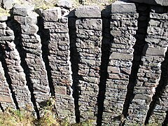 Stacked rock detail of lock wall of Upper Canal Lock 28 near White Haven, 2008


See also
- Delaware and Lehigh National Heritage Corridor
- List of canals in the United States
- Morris Canal – a New Jersey canal that provided direct access to the New York City markets via a cross-Delaware River connection in Phillipsburg, New Jersey
- Delaware Canal - A sister canal from the mouth of the Lehigh River and canal terminus, feeding urban Philadelphia connecting with the Morris and Lehigh Canals at their respective Easton terminals.
- Delaware and Raritan Canal – A New Jersey canal connection to the New York & New Jersey markets shipping primarily coal across the Delaware River. The D&R also shipped Iron Ore from New Jersey up the Lehigh.
- Chesapeake and Delaware Canal – A canal crossing the Delmarva Peninsula in the states of Delaware and Maryland, connecting the Chesapeake Bay with the Delaware Bay.
- Delaware and Hudson Canal - Another early built coal canal as the American canal age began; contemporary with the Lehigh and the Schuylkill navigations' The D&H connected the Hudson and the Delaware Rivers, giving industries in Eastern Pennsylvania access to shipping from New England and points in Eastern New York.
- Pennsylvania Canal System - ambitious collection of far flung canals, and eventually railroads authorized early in 1826.
- Pennsylvania Canal (Delaware Division) – the Delaware Canal – a sister canal along the Delaware River that provided a connection to the Philadelphia markets via a link up in Easton, PA. Via Easton and the Delaware River five different canals could transship cargoes from ports along the coastal waters of Long Island Sound between Connecticut and Long Island to Baltimore.
- Schuylkill Canal - Navigation joining Reading, PA and Philadelphia. The Schuylkill Canal was long delayed by investors quarreling over the best way to proceed and the willingness to invest enough fast enough to build an operational enterprise. Disgusted, White and Hazard explored tapping Anthracite via the Lehigh, and ended up incorporating the Lehigh Coal & Navigation Company which spearheaded many technological initiatives.
References
- ^ "National Register Information System". National Register of Historic Places. National Park Service. March 13, 2009.
- ^ a b c d e Bartholomew, Ann M.; Metz, Lance E.; Kneis, Michael (1989). DELAWARE and LEHIGH CANALS, 158 pages (First ed.). Oak Printing Company, Bethlehem, Pennsylvania: Center for Canal History and Technology, Hugh Moore Historical Park and Museum, Inc., Easton, Pennsylvania. ISBN 0930973097. LCCN 89-25150.
- ^ Operated by the 'Mauch Chunk Switchback Railway Company' title seen in a legal notice.
- ^ Brenckman, History of Carbon County.
- ^ Brenckman.
- ^ DEL&LHcanals.
- ^ HistNHampCntyPA, pp. Chapters XXXIV-XXXV.
- ^ a b c d Brenckman, Fredrick, History of Carbon County. Also, History of Northampton County overlaps.
- ^ Falls of the Schuylkill location. The area: "Industrial activity marked the early history of the Schuylkill River and nearby waterways. Even before the fishery of Fort St. Davids was established by Welshmen at the Falls of the Schuylkill in 1734, other settlers were building mills along the {{subst:123|Wissahickon|Creek}} and the Falls Creeks.
• Don't bother trying to find the Schuylkill Falls themselves, however. The Fairmount Dam, constructed in 1822, raised the river's water level and obliterated the rapids. The area near the present library was a brewery from 1873 to 1894. After it fell into disrepair, the springs turned it into a swimming hole." - ^ Bartholomew, Ann M.; Metz, Lance E.; Kneis, Michael (1989). Delaware and Lehigh Canals, 158 pages (First ed.). Oak Printing Company, Bethlehem, Pennsylvania: Center for Canal History and Technology, Hugh Moore Historical Park and Museum, Inc., Easton, Pennsylvania. pp. 4–5. ISBN 0930973097. LCCN 89-25150.
- ^ Alfred Mathews & Ausin N. Hungerford (1884). The History of the Counties of Lehigh & Carbon, Commonwealth of Pennsylvania. Philadelphia: Ancestry.com, Transcribed from the original in April 2004 by Shirley Kuntz.
- ^ a b c "National Register Information System". National Register of Historic Places. National Park Service. July 9, 2010.
- ^ "Lehigh Canal". National Canal Museum. Archived from the original on December 2, 2013. Retrieved November 23, 2013.
{{cite web}}: Unknown parameter|deadurl=ignored (|url-status=suggested) (help)
External links
- Historic American Engineering Record (HAER) No. PA-133, "Lehigh Canal, Easton Dam"
- Historic American Engineering Record (HAER) No. PA-136, "Lehigh Canal, Outlet Lock"
- Historic American Engineering Record (HAER) No. PA-139, "Lehigh Canal, Guard Lock 8 & Lockhouse"
- Historic American Engineering Record (HAER) No. PA-140, "Lehigh Canal, Lock 44"
- Historic American Engineering Record (HAER) No. PA-149, "Lehigh Canal, Lock 40"
- Historic American Engineering Record (HAER) No. PA-153, "Lehigh Canal, Hokendauqua Dam"
- Historic American Engineering Record (HAER) No. PA-158, "Lehigh Canal, Guard Lock 5"
- Historic American Engineering Record (HAER) No. PA-160, "Lehigh Canal, Lock 25"
- Historic American Engineering Record (HAER) No. PA-162, "Lehigh Canal, Lock 20"
- Historic American Engineering Record (HAER) No. PA-165, "Lehigh Canal, Lock 10"
- Historic American Engineering Record (HAER) No. PA-171, "Lehigh Canal, Slate Dam"
- Historic American Engineering Record (HAER) No. PA-176, "Lehigh Canal, Freemansburg"
- National Canal Museum: Lehigh Navigation
- Historic photos of the Lehigh Coal and Navigation Canal
- Delaware & Lehigh Canal State Heritage Corridor
- Lehigh Canal history

- Wikipedia articles needing copy edit from April 2017
- Aqueducts in the United States
- Navigable aqueducts
- Canals in Pennsylvania
- Canals on the National Register of Historic Places in Pennsylvania
- Archaeological sites on the National Register of Historic Places in Pennsylvania
- Historic American Engineering Record in Pennsylvania
- Transportation in Lehigh County, Pennsylvania
- Transportation in Northampton County, Pennsylvania
- Transportation in Carbon County, Pennsylvania
- Canals opened in 1829
- Historic districts on the National Register of Historic Places in Pennsylvania
- National Register of Historic Places in Northampton County, Pennsylvania
- National Register of Historic Places in Carbon County, Pennsylvania
- Aqueducts on the National Register of Historic Places