
Talk:List of U.S. states and territories by area: Difference between revisions
→Redundant tables: new section |
|||
| Line 107: | Line 107: | ||
::According to [[WP:TPG#YES]]: "Avoid excessive emphasis" the use of bold in this section is not in accordance with Wikipedia policy. Also, please indent appropriately and sign your posts with four tildes (~). Thank you! [[User:Adavis444|Adavis444]] ([[User talk:Adavis444|talk]]) 06:49, 19 August 2010 (UTC) |
::According to [[WP:TPG#YES]]: "Avoid excessive emphasis" the use of bold in this section is not in accordance with Wikipedia policy. Also, please indent appropriately and sign your posts with four tildes (~). Thank you! [[User:Adavis444|Adavis444]] ([[User talk:Adavis444|talk]]) 06:49, 19 August 2010 (UTC) |
||
:::I propose that a new column be added for land plus internal water. I am apparently not the only one who thinks this is a good measurement. The argument (see [[Talk:List of U.S. states and territories by area#Whether or not to include area of water in overall state ranking|below]]) that large sections of the Great lakes are within Michigan's borders does not quite convince me. [[commons:Category:Clickable map of USA|This series of images]] illustrates approximately what I mean. We need a measure of the area colored red for each state (with the possible exception of [[Lake Ponchartrain]]), which is what I, and perhaps many others consider to be the "true" are of the state. Is this what most states' official area figures would be? If so, that's a possible source. <sub>([[Special:Contributions/Phinumu|suoı̣ʇnqı̣ɹʇuoɔ]] · [[User_talk:Phinumu|ʞlɐʇ]])</sub> [[User:Phinumu|nɯnuı̣ɥԀ]] 19:58, 5 May 2014 (UTC) |
:::I propose that a new column be added for land plus internal water. I am apparently not the only one who thinks this is a good measurement. The argument (see [[Talk:List of U.S. states and territories by area#Whether or not to include area of water in overall state ranking|below]]) that large sections of the Great lakes are within Michigan's borders does not quite convince me. [[commons:Category:Clickable map of USA|This series of images]] illustrates approximately what I mean. We need a measure of the area colored red for each state (with the possible exception of [[Lake Ponchartrain]]), which is what I, and perhaps many others consider to be the "true" are of the state. Is this what most states' official area figures would be? If so, that's a possible source. <sub>([[Special:Contributions/Phinumu|suoı̣ʇnqı̣ɹʇuoɔ]] · [[User_talk:Phinumu|ʞlɐʇ]])</sub> [[User:Phinumu|nɯnuı̣ɥԀ]] 19:58, 5 May 2014 (UTC) |
||
::::I believe that most states would include Great Lakes water as part of their total area. I just checked Michigan's website and they definitely do. All of these charts use official census bureau statistics for total area and water area which definitely do include Great Lakes areas in the U.S. and even significant ocean areas bordering the states.. I do not believe the the census data has any information which would allow one to differentiate between water which is on the border of a state versus "internal water" that is totally surrounded by land of that state. Although I sympathize with your concern, you may not be able to find a source which enables you to do what you want, so it could be objected to as "original research." By the way, this sort of argument also occurs regarding how many states border a given state, since some of the border occur only in the middle of a lake (e.g. Michigan-Illinois and Michigan-Minnesota. But, check any state website and you will see that they include these "water borders". An even more "obtuse" border is that of New York and Rhode Island which occurs in the ocean. Regarding the maps you refer to, simply because a map shows only the land area of a state and not its total area including surrounding water does not mean that this water area is not part of the official area of the state. How much more official can you get that the U.S. Census Bureau? |
|||
== Total US Area Descrepancy == |
== Total US Area Descrepancy == |
||
Revision as of 20:24, 5 May 2014
| This article is written in American English, which has its own spelling conventions (color, defense, traveled) and some terms that are used in it may be different or absent from other varieties of English. According to the relevant style guide, this should not be changed without broad consensus. |


| United States List‑class Mid‑importance | ||||||||||
| ||||||||||

Meant to be tripled?
Is this article meant to be tripled? john k 19:30, 10 December 2005 (UTC)
Sea Area shouldn't be used to rank "Area" of the state
Massachussetts and Hawaii are both smaller than New Hampshire and Vermont, yet this table lists numbers that are not a true ranking of area. The land area of Mass is 7840 square miles and land area of Hawaii is 6423 sq. miles. The "Water Area" listed for both HI and MA here is dubious. It seems that the calculations listed in the table include a great deal of sea area. I object to listing states in area including the so-called "water area". I find that listing Massachussetts as larger than NH, VT to be inaccurate. I think the land area (including enclosed water area, but not water that is merely a border of a state such as the sea or great lakes) should be used for ranking. I think sea area or water area should be listed, but not included in the area ranking. Even the states themselves don't list themselves as having that area.
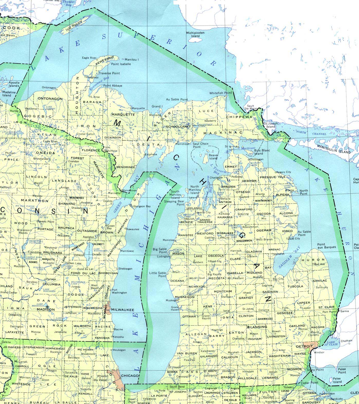
- I think you may have some arguments about not including ocean water as part of the total area. However, Great Lakes water is not "mearly a border of a state". The borders of Great Lakes states extend well out into Great Lakes water, so the water (and what's beneath) falls under the state's jurisdiction. You can see their borders extending out into the Great Lakes clearly by looking at a map of Michigan. Examples: http://www.lib.utexas.edu/maps/united_states/michigan_90.jpg and http://en.wikipedia.org/wiki/File:Michigan.svg Phizzy (talk) 16:47, 8 January 2009 (UTC)
- I agree with Phizzy. The total area of a state is it's total area whether it is sea, lake, swamp, land, ice caps, etc. Besides the total area numbers and ranking are set by a standard guideline through the USGS or the census bureau. For instance Michigan is really the 8th total largest state. But because we have to use a standardize source for it instead of more accurate state by state sources it is 11th. Strunke (talk) 20:11, 8 January 2009 (UTC)
West Virginia
can we get a better picture? seriously, there is a picture of a rocky cliff along the roadside and it claims to be WV. I dont get it. WikiTony 05:24, 27 February 2006 (UTC)
- I agree... I was going to delete it, but I didnt want to start any wars or anything. I also tried to clean up most of the picture descriptions--a lot of them used pronouns to make it [grammatically] appear that the thing pictured (not the state itself) had a certain area or something. //MrD9 06:16, 27 February 2006 (UTC)
- Someone has to be bold :) Most of the pictures are completely irrelevent to the article. Just random American skylines or views of rocks. Diliff | (Talk) (Contribs) 13:02, 10 March 2006 (UTC)
Total area
On this page, it says Maryland has a total area of 12,407 square miles (32,133 square km). On the page for Maryland, it says 12,417 square miles (32,160 km²). Which of these is correct? --Smiller933 21:29, 28 July 2006 (UTC)
- The Census Bureau gives Maryland's area as 12,406.68 square miles.[1] I'll correct the Maryland page. -- Avenue 13:05, 10 April 2007 (UTC)
water area
would it be better to list the water area by percentage rather than overall? -- Astrokey44|talk 23:48, 29 March 2006 (UTC)
- Actually, wouldn't it be better to have two maps, including the extant map and including a "Water area by percentage of total state area" map? I grew up near Rhode Island, so I think this would be a good addition to the article. --Mr Accountable (talk) 19:56, 29 September 2008 (UTC)
You also have 8729 on the New Jersey page and 8721 on the states by area page, and another website I looked at said 7787. Please clarify.
definition of water area?
Water area isn't defined. Comparing some listed data for Michigan, New Jersey, and Hawaii, it appears that (apart from the area of enclosed lakes and rivers) water area is defined as the shore length times 12 miles (the usual, but not universal, territorial limit). Can someone please confirm this and footnote the column heading, or otherwise define terms and assumptions? Paulownia5 21:40, 3 January 2007 (UTC)
Water area needs to be defined. Land Area is a cleare defination, yet water area is not... Does it only incorperate landlocked water or also shorelines?
- I added some defining characteristics extracted from Census 2000 Geographic Terms and Concepts. Land area isn't entirely straightforward either. -- Avenue 12:54, 10 April 2007 (UTC)
There's no hard and fast rule for all water boundaries. For the ocean and sea coasts, the area defined should be up to the 12-mile limit. For river boundaries, it's normally up to the middle of the channel unless otherwise defined by law, such as the Potomac, which belongs to Maryland in its entirety. There is no 12-mile limit for the Great Lakes; those boundaries were defined by the Treaty of Paris in 1783. Great Lakes boundaries between states are defined in law, which explains why Isle Royale is in Michigan despite being much closer to Ontario and Minnesota. -- SpanishCastleMagic (talk) 03:06, 16 March 2008 (UTC)
Rhode Island
Image:RI towns labeled.png is deleted from Commons for having a non-commercial license. [2]--Jusjih 12:10, 14 September 2006 (UTC)
Miles before Kilometers
Shouldn't miles come before kilometers in the chart? After all, American statistics on geographical area are generally written in miles not kilometers. —Preceding unsigned comment added by 67.72.98.93 (talk) 04:00:15, 20 November 2006 (UTC)
- In response to this comment I have decided to add the template {{American English}} to this article, even though the article already is in accordance with the above recommendation. Adavis444 (talk) 06:49, 19 August 2010 (UTC)
Non States
I know it kind of defeats the purpose of the title, but lists like this commonly have at least Washington DC and Puerto Rico included. I think we should add them here as well for comparison. Papercrab 22:39, 20 November 2006 (UTC)
- I agree. For one thing, the Census Bureau tables I've seen that provide this information include both these entities. DC's in the list now. Does anyone object to Puerto Rico being added? -- Avenue 13:17, 10 April 2007 (UTC)
Top Image
You know, I really think that the image at the top of the page would be more effective if it visually demonstrated that Alaska is nearly three times the size of Texas. In the current image, it appears to be smaller. I'll sleuth around for something permissible, but if anyone has one or knows how to make one, that too would be excellent. CharacterZero | Speak 03:29, 13 December 2006 (UTC)
- I added the one that I made from the image at Wikipedia Commons. It doesn't have all of the Aleutian Islands on it, but I figured it worked for the most part. Frank12 01:13, 21 August 2007 (UTC)
- The top maps are inappropriate given the subject of the page. The caption says,"US states by land area. (Note: Alaska and Hawaii are not depicted to the same scale as the continental US.)" The image should depict Alaska and Hawaii to scale, since scale is precisely the point. 67.101.37.122 (talk) 03:40, 30 December 2008 (UTC)
- You can create better versions using this blank map if you wish. I imagine a scatterplot would probably be more useful than two separate patch maps, however, especially since the color scale on the first one is essentially redundant, as land areas are visible directly. -- Avenue (talk) 08:06, 30 December 2008 (UTC)
- Also, the first map is supposed to show US states by LAND area, but it is clearly showing by TOTAL area. I've created three new maps, showing by total area, land area, and water area, with Alaska and Hawaii at the same scale as the other 48 states. At the moment, these are png maps, as my svg versions are not displaying properly (I need to fix this). Phizzy (talk) 16:18, 31 December 2008 (UTC)
Land Area removal
Why was the land area removed, that should be included along with total and water. The color coded picture next to total is only land area not total area so it should be removed if there is no land area. I will be adding land area back to this page. Strunke 16:07, 10 April 2007 (UTC)
Georgia and Michigan land area
I'm pretty sure Georgia has more...please fix —The preceding unsigned comment was added by 70.141.5.124 (talk • contribs)
- Currently the list gives Michigan and Wyoming special treatment, using more recent figures provided by those two states. Unless someone can give a good reason to believe that these more recent figures are more accurate, I believe we should use the Census Bureau figures throughout. This would incidentally put Georgia ahead of Michigan on land area. -- Avenue 06:32, 10 July 2007 (UTC)
- The state numbers are more accurate. Census bureau information is for collecting data on the people not the geography itself. If they are off a little with this information they don't really care as much. The land area for Michigan is 58,110 sq. miles with 38,575 of great lakes water. Strunke 19:02, 11 July 2007 (UTC)
Missing info
Each table should also tell what percentage of the national area each state makes up, by each criterion. --Kevlar (talk • contribs) 10:15, 12 June 2008 (UTC)
Montana tidbit
"Montana is larger than every state it borders; "
Well, that's true enough, but it's also true of California, New York, & (by land area, anyway) Georgia. Whoopie!
BibblyBobb (talk) 08:51, 15 June 2008 (UTC)
Combined Table
I think it would be good to combine all this information into one table. It would make it easier to compare the different area values for a given state or territory. (I could do this myself, but I thought I'd see what other people thought first.) --Lasunncty (talk) 09:14, 17 June 2008 (UTC)
Land area of the states
In the 50 articles about the states, shouldn't we just calculate land area, not total area? Water area doesn't really count as part of a state. For example, when finding the area of Florida, we don't count the area of Tampa Bay. Footballfan190 (talk) 06:26, 9 July 2008 (UTC)
- Water area does count. Are you saying Lake Okeechobee, at 730 square miles, shouldn't be counted in Florida's total area? Shouldn't Lake Superior, Lake Michigan, Lake Huron, and Lake Erie be counted in Michigan's total area? Great Lakes waters within Michigan's borders account for 38,192 square miles of Michigan's total area. 38,192 square miles is bigger than the total area of the state of Indiana, and twelve smaller states. Phizzy (talk) 19:01, 6 January 2009 (UTC)
- I suggest that enclosed water counts, but not the ocean or shared bodies of water. Land area is well defined, but once you start including seas then states that border the sea are listed as much bigger even though we know they are not bigger. Can you stand or live in water? Why not just use the state's official area listings rather than adding the ocean to a state's area. I think it is inaccurate to represent Massachussetts as bigger than Vermont. Those of us from the New England area know that VT is much bigger than Massachussetts. What are they tying to do, make their states seem bigger?—Preceding unsigned comment added by 64.30.3.122 (talk) 2009-01-08T11:47:53
- If the water is included within its borders, yes, you should count it. By your definition, you have to be able to "stand or live" on it to include it? Should we not include mountainous areas? You can't live on the top of Mt. St. Helens. What about municipal dumps and contaminated land? You can't live in those places as well. Furthermore, you CAN live on the water, as many people do, and the Great Lakes are a much more important resource than the mountains of New Hampshire and Vermont. Phizzy (talk) 17:02, 8 January 2009 (UTC)
- According to WP:TPG#YES: "Avoid excessive emphasis" the use of bold in this section is not in accordance with Wikipedia policy. Also, please indent appropriately and sign your posts with four tildes (~). Thank you! Adavis444 (talk) 06:49, 19 August 2010 (UTC)
- I propose that a new column be added for land plus internal water. I am apparently not the only one who thinks this is a good measurement. The argument (see below) that large sections of the Great lakes are within Michigan's borders does not quite convince me. This series of images illustrates approximately what I mean. We need a measure of the area colored red for each state (with the possible exception of Lake Ponchartrain), which is what I, and perhaps many others consider to be the "true" are of the state. Is this what most states' official area figures would be? If so, that's a possible source. (suoı̣ʇnqı̣ɹʇuoɔ · ʞlɐʇ) nɯnuı̣ɥԀ 19:58, 5 May 2014 (UTC)
- I believe that most states would include Great Lakes water as part of their total area. I just checked Michigan's website and they definitely do. All of these charts use official census bureau statistics for total area and water area which definitely do include Great Lakes areas in the U.S. and even significant ocean areas bordering the states.. I do not believe the the census data has any information which would allow one to differentiate between water which is on the border of a state versus "internal water" that is totally surrounded by land of that state. Although I sympathize with your concern, you may not be able to find a source which enables you to do what you want, so it could be objected to as "original research." By the way, this sort of argument also occurs regarding how many states border a given state, since some of the border occur only in the middle of a lake (e.g. Michigan-Illinois and Michigan-Minnesota. But, check any state website and you will see that they include these "water borders". An even more "obtuse" border is that of New York and Rhode Island which occurs in the ocean. Regarding the maps you refer to, simply because a map shows only the land area of a state and not its total area including surrounding water does not mean that this water area is not part of the official area of the state. How much more official can you get that the U.S. Census Bureau?
- I propose that a new column be added for land plus internal water. I am apparently not the only one who thinks this is a good measurement. The argument (see below) that large sections of the Great lakes are within Michigan's borders does not quite convince me. This series of images illustrates approximately what I mean. We need a measure of the area colored red for each state (with the possible exception of Lake Ponchartrain), which is what I, and perhaps many others consider to be the "true" are of the state. Is this what most states' official area figures would be? If so, that's a possible source. (suoı̣ʇnqı̣ɹʇuoɔ · ʞlɐʇ) nɯnuı̣ɥԀ 19:58, 5 May 2014 (UTC)
Total US Area Descrepancy
In Continental United States the total area of the contiguous states is given to be 8,080,464.25 km2. But by taking the sum of the areas given in this article (of the 48 contiguous states), an area of 8,083,268 km2 is found. This is a descrepancy of almost 3000 km. Malcolmst (talk) 10:11, 29 July 2008 (UTC) I hope the discrepancy is 3000 km2 and not km. Even with 3000 km2, the error is 0.37 parts per thousand or equivalently the ability to spot 4 grains of sand in 10,000 grains of salt.DaHealuh (talk) 18:52, 2 November 2012 (UTC)ronald
Map with states scaled by "land area"
Deleted this figure because it was clearly incorrect. It was labeled on the image itself and the title that it was the states by "land area", but it was definitely by "total area". Someone needs to find an accurate map to display because I am in a rush. —Preceding unsigned comment added by MPWilk (talk • contribs) 03:48, 3 September 2008 (UTC)
Massachusetts Error
The land area of Massachussetts is incorrect. Massachussetts is smaller than both New Hampshire and Vermont, yet this table and the Massachussetts state site list a number that is not right. The land area of Mass is 7840 square miles. —Preceding unsigned comment added by 64.30.3.122 (talk) 11:28 am, 8 January 2009 (UTC−5)
Whether or not to include area of water in overall state ranking
Massachussetts and Hawaii are both smaller than New Hampshire and Vermont, yet this table lists numbers that are not a true ranking of area. The land area of Mass is 7840 square miles and land area of Hawaii is 6423 sq. miles. The "Water Area" listed for both HI and MA here is dubious. It seems that the calculations listed in the table include a great deal of sea area. I object to listing states in area including the so-called "water area". I find that listing Massachussetts as larger than NH, VT to be inaccurate. I think the land area (including enclosed water area, but not water that is merely a border of a state such as the sea or great lakes) should be used for ranking. I think sea area or water area should be listed, but not included in the area ranking. Even the states themselves don't list themselves as having that area.—Preceding unsigned comment added by 64.30.3.122 (talk) 2009-01-08T11:38:07
- I think you may have some arguments about not including ocean water as part of the total area. However, Great Lakes water is not "mearly a border of a state". The borders of Great Lakes states extend well out into Great Lakes water, so the water (and what's beneath) falls under the state's jurisdiction. You can see their borders extending out into the Great Lakes clearly by looking at a map of Michigan. Examples: http://www.lib.utexas.edu/maps/united_states/michigan_90.jpg and http://en.wikipedia.org/wiki/File:Michigan.svg Phizzy (talk) 16:47, 8 January 2009 (UTC)
- I agree with Phizzy. The total area of a state is it's total area whether it is sea, lake, swamp, land, ice caps, etc. Besides the total area numbers and ranking are set by a standard guideline through the USGS or the census bureau. For instance Michigan is really the 8th total largest state. But because we have to use a standardize source for it instead of more accurate state by state sources it is 11th. Strunke (talk) 20:11, 8 January 2009 (UTC)
Lots on inconsistencies.
There seem to be lots on inconsistencies in this article, especially regarding water areas.
For Michigan the numbers for lard and water don't add up to the total.
The captions on the last 2 pictures:
"Sunset on Lake Michigan. Michigan is second behind Alaska in water area." and "Florida is mostly a peninsula, and has the third largest water area and seventh largest water area percentage" would suggest that the top 3 in water area is:
1) Alaska 2) Michigan 3) Florida
But the Chart would suggest that the rank would be:
1) Alaska 2) Minnesota 3) Florida 4) Wisconsin 5) Louisiana 6) California 7) Michigan
May of the numbers do not agree with what you find on the individual state pages.
Brewmenn (talk) 05:34, 18 May 2010 (UTC)
- Not sure what you are looking at, but if you sort on "water (sq mi)" (descending), you'll find the following:
- 1) Alaska - 91,316.00 square miles
- 2) Michigan - 39,912.28
- 3) Florida - 11,827.77
- 4) Wisconsin - 11,187.72
- 5) Louisiana - 8,277.85
- 6) California - 7,736.23
- 7) New York - 7,342.22
- Michigan is clearly number #2. It has more water surface area than the next four states combined. I guess that is one reason Michigan is called the "Great Lakes State". Phizzy
 20:25, 2 June 2011 (UTC)
GUAM There is a contradiction with the page about GUAM (200 sq. Km/541 sq. Miles) which is much smaller.--79.154.37.80 (talk) 03:25, 28 December 2010 (UTC)
I've noticed several of the numbers don't match up the source that was given by the article here:
http://www.census.gov/compendia/statab/2012/tables/12s0358.pdf
Alaska, for example, is given as 663,267 sq mi but the Census table's number is 664,988 sq mi. Where did '663,267' come from? Ww7439 (talk) 02:27, 29 December 2013 (UTC)
- The source used was the 2000 Census. I just found the areas used in the 2010 census, so I will update this article soon. --Lasunncty (talk) 07:29, 1 January 2014 (UTC)
comparable countries
This column was added on April 21. I'm not sure it is necessary. I see one person tried to remove it but was reverted. Can we have some discussion about whether this is encyclopedic? My stance is that if you really want to know which countries are comparable in size, you should refer to List of countries by percentage of water area (although that article need some work). --Lasunncty (talk) 07:42, 14 June 2011 (UTC)
- I think it is interesting and puts things into context. They are not just numbers. — Preceding unsigned comment added by Chogg (talk • contribs) 18:08, 28 June 2011 (UTC)
- I think it is a very good column to have in the matrix. It adds info that provides an example that is more-or-less instantly recognizable by the casual reader (both American and international). I not only say leave it in, I say add similar columns to other articles (e.g., Canadian Provinces, counties in states, etc.).
- Bravo Editor!
- 72.82.176.105 (talk) 22:07, 2 July 2011 (UTC)
- It seems that there are a number of obvious omissions in the list of countries. For instance, Guyana is listed 4 times, but Metropolitan/European/Continental France is a better match in size to Kansas; Great Britain is a good match to Minnesota, but Guyana is listed for these two states. I'd argue that Western European counties, are better known to the reader of the English version of Wikipedia, than the other countries listed.
- 108.7.187.186 (talk) 04:53, 24 January 2012 (UTC)
Based on recent comments, the comparable country columns are creating a lot of confusion. While the information provided might be interesting, it is not necessary for this article and could be obtained in other ways. I again propose removing these columns. --Lasunncty (talk) 23:09, 2 November 2012 (UTC)
It is mathematically impossible to have Libya as the comparable country for the 'US average' state as well as for the largest state Alaska. It obviously shouldn't be the comparable country to the US Average, Libya's area is simply way too large. — Preceding unsigned comment added by 202.156.65.75 (talk) 10:21, 4 January 2013 (UTC)
highly contradictory / confusing presentation
A country can't have multiple values for area, yet every country that's listed has multiple values under total and also under land. There should only be one total area value and one land area value.
Further, with states, it's only total area, why aren't land area stats given, if we use land area stats for comparable countries?
-- 65.92.181.190 (talk) 13:32, 31 October 2012 (UTC)
- This table only lists state areas, not country areas. The comparable countries are the ones closest to the areas of the states. There is no contradiction. --Lasunncty (talk) 23:05, 2 November 2012 (UTC)
- Did you even read the data given for countries?
Total area Greece
sq.mi		sq.km
52,068.17	134,856
50,744.00	131,426
43,561.85	112,825
- This is clearly impossible, and clearly contradictory, and it's not the only case. -- 65.92.181.190 (talk) 05:17, 3 November 2012 (UTC)
- That still makes no sense, why put a flag there for some country, with no data for it? How are we supposed to "compare" the value for the state with the value for the country? This entire country thing looks very bad in that case. One of these is already missing a country comparator, since there are only two country columns, not three. -- 65.92.181.190 (talk) 05:59, 4 November 2012 (UTC)
San Bernardio County?
That little section of it doesn't make any sense, "San Bernardino County is the largest county in the U.S. and is larger than each of the nine smallest states, including larger than the four smallest states combined." Could someone rephrase this? — Preceding unsigned comment added by 75.64.104.4 (talk) 22:34, 31 October 2012 (UTC)
Makes sense to me.DaHealuh (talk) 18:55, 2 November 2012 (UTC)ronald
unreferenced countries
All the countries are unreferenced. That needs fixing, especially since the data there is contradictory. -- 65.92.181.190 (talk) 05:23, 3 November 2012 (UTC)
Total area vs land area
How come Maryland and Puerto Rico have bigger figures for the latter than for the former? 37.190.158.177 (talk) 17:18, 15 November 2012 (UTC)
"US average"
I find this row to be unnecessary at best and misleading at worst. Any objections to removing it? --Lasunncty (talk) 05:16, 15 March 2013 (UTC)
Arizona and Nevada
There is no information on Nevada or Arizona. Why is that? --emetzold (talk) 19:16, 15 July 2013 (UTC)
- 6 and #7 are missing from the list. Are these the two missing states? — Preceding unsigned comment added by 71.218.168.192 (talk) 08:26, 17 July 2013 (UTC)
Comparable countries take two
The whole column seems to be some sort of original research - no sources - I can think of many countries for each one - who picked theses ones? Is there some sort of academic comparison between these countries or is this just guess work base of sources that indicate some sort of comparison is proper? -- Moxy (talk) 20:49, 7 August 2013 (UTC)
- Remove columns: This is original research by synthesizing published material. Combining a reliable source of areas of US states with a separate (presumably) reliable source of areas of independent nations for the purpose of comparison is known as "combining published sources in a way to imply something that none of them explicitly say". Unless there is a reliable source out there that explicitly verifies that the most comparable country to Alaska in terms of area is Iran, and so on for the other 49 states and other entries, then there is no basis to consider inclusion of comparable counties in this article.
Even if a reliable source were to exist however, such information is trivia, being "information that is not important to the subject it is being presented in relation to." Essentially, inclusion of trivia is generally discouraged. In this case, it is not important to know on this article that Samoa is Rhode Island's most comparable country in terms of area. Sure, this information may be of interest to some readers, but this trivia is not relevant enough to be included within the article and by no means does it make the article more complete.
More than anything, all this does is satisfy the fantasy question of "if North Dakota was its own country, where would it rank?" Not encyclopedic. Hwy43 (talk) 21:03, 7 August 2013 (UTC)
- This is take 3 actually (look at the contradictory/confusing section above)
- Remove columns per the contradictory/confusing discussion section, they make no sense, and don't even provide any comparison information, since the data is wholly missing
- (this is the third year in a row it's been discussed and found confusing...) -- 76.65.128.222 (talk) 01:56, 8 August 2013 (UTC)
- I wouldn't consider it original research since it is merely a comparison of numbers, plus I'm sure it could be found in some source if we looked for it. I would however consider it trivia and therefore support removal. Not to mention its presentation remains confusing despite efforts to make it clearer. --Lasunncty (talk) 09:27, 19 August 2013 (UTC)
It has been over three weeks. Based on the above, the comparable countries columns have been removed. Hwy43 (talk) 04:00, 2 September 2013 (UTC)
Georgia
I genuinely have no idea how to fix it, but the page is showing the country Georgia instead of the state... --94.43.9.81 (talk) 10:43, 8 February 2014 (UTC)
Redundant tables
I removed one of the two tables that are identical except for how they are sorted. KenHigh reverted my edit, saying "Although the only difference is sort order the mobile site does not have a sort feature, making this one alternative sort useful information." I have never seen this sort of thing on any other Wikipedia article. What is the useful information contained in the "total area sort"? Is it the territories and regions being ordered by area in the same table as the states? (suoı̣ʇnqı̣ɹʇuoɔ · ʞlɐʇ) nɯnuı̣ɥԀ 20:19, 5 May 2014 (UTC)