Életot
Tools
Actions
General
Print/export
Print/export
In other projects
From Wikipedia, the free encyclopedia
This is an old revision of this page, as edited by Addbot (talk | contribs) at 13:13, 22 February 2013 (Bot: Migrating 20 interwiki links, now provided by Wikidata on d:q774763 (Report Errors)). The present address (URL) is a permanent link to this revision, which may differ significantly from the current revision.
Place in Normandy, France
Életot | |
|---|---|
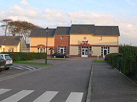
 Town hall and post office | |
| Country | France |
| Region | Normandy |
| Department | Seine-Maritime |
| Arrondissement | Le Havre |
| Canton | Valmont |
| Intercommunality | Canton of Valmont |
| Area 1 | 6.81 km2 (2.63 sq mi) |
| Population (2006) | 595 |
| • Density | 87/km2 (230/sq mi) |
| Time zone | UTC+01:00 (CET) |
| • Summer (DST) | UTC+02:00 (CEST) |
| INSEE/Postal code | 76232 /76540 |
| Elevation | 0–118 m (0–387 ft) (avg. 100 m or 330 ft) |
| 1 French Land Register data, which excludes lakes, ponds, glaciers > 1 km2 (0.386 sq mi or 247 acres) and river estuaries. | |
Életot is a commune in the Seine-Maritime department in the Haute-Normandie region in northern France.
Geography
A farming village on the coast of the Pays de Caux, situated some 32 miles (51 km) northeast of Le Havre, on the D79 road. A pebble beach and spectacular limestone cliffs can be reached by way of the steps of the val d’Ausson.
Heraldry
 |
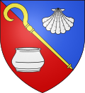
The arms of Életot are blazoned : Per bend sinister azure and gules, an abbot's crozier Or bendwise sinister between an escallop and a roman vase argent.
|
Population
| Year | 1962 | 1968 | 1975 | 1982 | 1990 | 1999 | 2006 |
|---|---|---|---|---|---|---|---|
| Population | 500 | 508 | 516 | 510 | 552 | 537 | 595 |
| From the year 1962 on: No double counting—residents of multiple communes (e.g. students and military personnel) are counted only once. | |||||||
Places of interest
- The church of St.Pierre, dating from the seventeenth century.
See also
References
External links
Wikimedia Commons has media related to Életot.
Retrieved from "https://en.wikipedia.org/w/index.php?title=Életot&oldid=539647729"
Hidden categories:
- Articles with short description
- Short description is different from Wikidata
- Pages using infobox settlement with image map1 but not image map
- Pages using infobox settlement with no coordinates
- Pages using infobox French commune with unknown parameters
- France articles requiring maintenance
- Commons category link from Wikidata
- All stub articles
- Pages using the Kartographer extension


