Araraquara
Araraquara | |
|---|---|
 | |
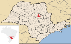
 Location in São Paulo state | |
| Coordinates: 21°47′38″S 48°10′33″W / 21.79389°S 48.17583°W | |
| Country | Brazil |
| Region | Southeast |
| State | São Paulo |
| Government | |
| • Mayor | Edinho Silva (PT) |
| Area | |
| • Total | 1,004 km2 (388 sq mi) |
| Elevation | 664 m (2,178 ft) |
| Population (2020 [1]) | |
| • Total | 238,339 |
| • Density | 240/km2 (610/sq mi) |
| Time zone | UTC-03:00 (BRT) |
| • Summer (DST) | UTC-02:00 (BRST) |
| Postal code | 14801 |
| Area code | +(55) 16 |
| Website | Official website |
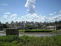
Araraquara (Portuguese pronunciation: [ɐɾaɾɐˈkwaɾɐ] or [aˌɾaɾɐˈkwaɾɐ]) is a city in the state of São Paulo in Brazil. The population is 238,339 (2020 est.) in an area of 1004 km².[2] It is also known as "the abode of the sun," because of its impressive sunset and because of its hot atmosphere, especially in summer. The city was founded in 1817.
History
Etymology
There are two possible origins for the name of the city, one that links it to the Tupi-Guarani language of the region's indigenous inhabitants, and one that relates it to the Língua Geral of São Paulo.[3] The two versions come from similar expressions, "arará kûara" and "arara kûara", which mean "lair of the macaws."[3]
Geography
The city is in the Microregion of Araraquara, part of the Mesoregion of Araraquara, 270 km north of São Paulo.
Transport
The city is served by Bartolomeu de Gusmão Airport.
Sport
Ferroviária is the local football (soccer) team of the city. The club plays home matches at Estádio Fonte Luminosa, which has a maximum capacity of 27,000 people.
References
- ^ IBGE 2020
- ^ Instituto Brasileiro de Geografia e Estatística
- ^ a b Navarro, Eduardo de Almeida (2013). Dicionário de Tupi Antigoː a Língua Indígena Clássica do Brasil. São Paulo: Global. p. 544.
External links
 Media related to Araraquara at Wikimedia Commons
 Araraquara travel guide from Wikivoyage
- (in Portuguese) Official website


