Outline of Mali


The following outline is provided as an overview of and topical guide to Mali:
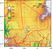
Mali – landlocked sovereign country located in West Africa.[1] Mali is the seventh most extensive country in Africa, bordering Algeria on the north, Niger on the east, Burkina Faso and the Côte d'Ivoire on the south, Guinea on the south-west, and Senegal and Mauritania on the west.
Consisting of eight regions, Mali's borders on the north reach deep into the middle of the Sahara, while the country's southern region, where the majority of inhabitants live, features the Niger and Senegal rivers. The country's economic structure centers around agriculture and fishing. Some of Mali's natural resources include gold, uranium, and salt. Due to a high incidence of poverty, Mali is considered to be one of the poorest nations in the world.
Present-day Mali was once part of three West African empires that controlled trans-Saharan trade: the Ghana Empire, the Mali Empire (from which Mali is named), and the Songhai Empire. In the late 19th century, Mali fell under French control, becoming part of French Sudan. Mali gained independence in 1959 with Senegal, as the Mali Federation in 1959. A year later, the Mali Federation became the independent nation of Mali in 1960. After a long period of one-party rule, a 1991 coup led to the writing of a new constitution and the establishment of Mali as a democratic, multi-party state.
General reference

- Pronunciation: /ˈmɑːli/
- Common English country name: Mali
- Official English country name: The Republic of Mali
- Common endonym(s):
- Official endonym(s):
- Adjectival(s): Malian
- Demonym(s):
- Etymology: Name of Mali
- ISO country codes: ML, MLI, 466
- ISO region codes: See ISO 3166-2:ML
- Internet country code top-level domain: .ml
Geography of Mali

- Mali is: a landlocked country
- Population of Mali: 12,337,000 - 71st most populous country
- Area of Mali: 1,240,192 km2
- Atlas of Mali
Location
- Mali is situated within the following regions:
- Northern Hemisphere and lies on the Prime Meridian
- Africa
- North Africa
- West Africa
- partially within the Sahara Desert
- Africa
- Northern Hemisphere and lies on the Prime Meridian
- Time zone: Coordinated Universal Time UTC+00
- Extreme points of Mali
- High: Hombori Tondo 1,155 m (3,789 ft)
- Low: Senegal River 23 m (75 ft)
- Land boundaries: 7,243 km
 Mauritania 2,237 km
 Algeria 1,376 km
 Burkina Faso 1,000 km
 Guinea 858 km
 Niger 821 km
 Cote d'Ivoire 532 km
 Senegal 419 km
- Coastline: none
Environment of Mali

- Climate of Mali
- Environmental issues in Mali
- Wildlife of Mali
- Fauna of Mali
Natural geographic features of Mali
- Glaciers in Mali: none [2]
- Rivers of Mali
- World Heritage Sites in Mali
Regions of Mali
Ecoregions of Mali
List of ecoregions in Mali
Administrative divisions of Mali
Administrative divisions of Mali
Regions of Mali
Cercles of Mali
Arrondissements of Mali
Communes of Mali
Municipalities of Mali
- Capital of Mali: Bamako
- Cities of Mali
Demography of Mali
Government and politics of Mali
- Form of government: presidential representative democratic republic
- Capital of Mali: Bamako
- Elections in Mali
- Political parties in Mali
Branches of the government of Mali
Executive branch of the government of Mali
Legislative branch of the government of Mali
- Parliament of Mali (bicameral)
- Upper house: Senate of Mali
- Lower house: House of Commons of Mali
Judicial branch of the government of Mali
Court system of Mali
Foreign relations of Mali
International organization membership
The Republic of Mali is a member of:[1]
Law and order in Mali
Law of Mali
Military of Mali
- Command
- Forces
- Army of Mali
- Navy of Mali: None
- Air Force of Mali
Local government in Mali
Local government in Mali
History of Mali
Culture of Mali
- Architecture of Mali
- Cuisine of Mali
- Languages of Mali
- Media in Mali
- National symbols of Mali
- Public holidays in Mali
- Religion in Mali
- World Heritage Sites in Mali
Art in Mali

Sports in Mali
Sports in Mali
Economy and infrastructure of Mali
- Economic rank, by nominal GDP (2007): 131st (one hundred and thirty first)
- Agriculture in Mali
- Communications in Mali
- Companies of Mali
- Currency of Mali: Franc
- Health care in Mali
- Mining in Mali
- Stock Exchange in Mali: none – served by the regional stock exchange Bourse Régionale des Valeurs Mobilières (BRVM) in Abidjan, Côte d'Ivoire.
- Tourism in Mali
- Transport in Mali
Education in Mali
Health in Mali
See also
- Index of Mali-related articles
- List of international rankings
- List of Mali-related topics
- Member state of the United Nations
- Outline of Africa
- Outline of geography
References
- ^ a b "Mali". The World Factbook. United States Central Intelligence Agency. July 3, 2009. Retrieved July 23, 2009.
- ^ The only glaciers in Africa are on Mt Kenya (in Kenya), on Kilimanjaro (in Tanzania), and in the Ruwenzori Mountains (which are located in Uganda and the Democratic Republic of the Congo). See Proceedings of the Riederalp Workshop, September 1978; Actes de l'Atelier de Riederalp, septembre 1978): IAHS-AISH Publ. no. 126, 1980.
External links
- Official Portal of the Government of Mali Official Portal of Government of Mali
- BBC News Country Profile - Mali
- CIA World Factbook - Mali
- Template:Dmoz
 Mali travel guide from Wikivoyage
- Government of Mali Tourism Site - English[permanent dead link]


