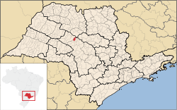
Pongaí
Appearance
Pongaí | |
|---|---|
 Location in São Paulo state | |
| Coordinates: 21°44′11″S 49°22′0″W / 21.73639°S 49.36667°W | |
| Country | Brazil |
| Region | Southeast |
| State | São Paulo |
| Area | |
• Total | 183 km2 (71 sq mi) |
| Population (2020 [1]) | |
• Total | 3,400 |
| • Density | 19/km2 (48/sq mi) |
| Time zone | UTC-03:00 (BRT) |
| • Summer (DST) | UTC-02:00 (BRST) |
Pongaí is a municipality in the state of São Paulo in Brazil. The population is 3,400 (2020 est.) in an area of 183 km².[2] The elevation is 422 m.


