Mulwala Bridge
Appearance
Mulwala Bridge | |
|---|---|
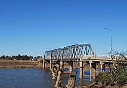
 The Mulwala Bridge over an empty Lake Mulwala, in 2009. Yarrawonga can be seen on the far side of the empty lake and the original path of the Murray River is clearly visible. | |
| Coordinates | 36°00′15″S 146°00′15″E / 36.0043°S 146.0041°E |
| Crosses | Lake Mulwala, Murray River |
| Locale | Mulwala, New South Wales, Australia |
| Named for | Mulwala |
| Owner | |
| Maintained by | Transport for New South Wales |
| Preceded by | John Foord Bridge |
| Followed by | Yarrawonga Rail Bridge |
| Characteristics | |
| Design | Pratt truss |
| History | |
| Designer | Percy Allan |
| Construction end | 1924 |
| Location | |
 | |
The Mulwala Bridge is a road bridge over Lake Mulwala, formed by a weir on the Murray River, on the state border between New South Wales and Victoria in Australia. The bridge links the border towns of Yarrawonga in Victoria and Mulwala in New South Wales. The bridge was built in 1924 and designed by Percy Allan using a Pratt truss.[1]
See also
References
- ^ "Mulwala Bridge over Murray River". Roads and Transport Authority (NSW). Retrieved 19 July 2010.
External links
Wikimedia Commons has media related to Mulwala Bridge.
Categories:
- Crossings of the Murray River
- Road bridges in New South Wales
- Bridges completed in 1924
- 1924 establishments in Australia
- Truss bridges in Australia
- Bridges designed by Percy Allan
- Allan truss bridges
- Borders of New South Wales
- Borders of Victoria (Australia)
- Bridges in the Riverina
- Australian bridge (structure) stubs
- New South Wales building and structure stubs
