Lancashire Witches Walk
53°58′05″N 2°26′10″W / 53.968°N 2.436°W
| Lancashire Witches Walk | |
|---|---|
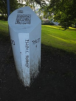
 A tercet waymarker at Clitheroe Castle | |
| Length | 51 mi (82 km) |
| Location | Lancashire, England |
| Trailheads | Barrowford, Lancaster |
| Use | Hiking |
The Lancashire Witches Walk is a 51-mile (82 km) long-distance footpath opened in 2012, between Barrowford and Lancaster, all in Lancashire, England. It starts at Pendle Heritage Centre in Barrowford before passing through the Forest of Pendle, the town of Clitheroe and the Forest of Bowland to finish at Lancaster Castle.[1]
The route was created to commemorate the 400th anniversary of the trials of the Pendle witches. Ten cast iron tercet waymarkers, designed by Stephen Raw, each inscribed with a verse of a poem by the poet laureate Carol Ann Duffy, have been installed at sites along the way.[2]
History
[edit]The route was designed by Ian Thornton-Bryar and John Sparshatt, following initial suggestions from Sue Flowers, the artistic director of the Lancashire-based arts organization Green Close.[3]
Route
[edit]The sustainable 51-mile long-distance walk commemorates the 400th anniversary of the hanging of nine of the Lancashire Witches. Starting in Barrowford and finishing at Lancaster Castle, where the witches were tried, the walk follows the most likely route that the witches were taken, on their way to be sentenced and hanged. Conveniently, the route also visits some of Lancashire’s best fells, using Slaidburn YHA as a base, almost exactly halfway along. While the start, finish and mid-points are accessible by public transport, much of the rest is remote. Green Close, a rural arts organisation based in the village of Melling, organised the installation of 10 half-tonne cast-iron installations on or near the path, embossed with stanzas of the walk’s poem, written by the poet laureate Carol Ann Duffy, all funded by the Heritage Lottery Fund. The route has been used in seven walking festivals (one by Clitheroe, two by Bowland and four by The Pendle Walking Festival). One originally Lancaster-based charity has used it to raise £5,200, by getting 50 youngsters to walk the northern half on midsummer's days.
Tercet waymarkers
[edit]| Tercet waymarker locations | ||
|---|---|---|
| No. (ref) | Location | Coordinates |
| One [4] | Pendle Heritage Centre, Barrowford | 53°51′12″N 2°12′41″W / 53.8533°N 2.2113°W |
| Two [5] | Ogden Valley, near Barley | 53°51′16″N 2°17′16″W / 53.8545°N 2.2879°W |
| Three [6] | Spring Wood, near Whalley | 53°49′13″N 2°23′41″W / 53.8202°N 2.3947°W |
| Four [6] | Clitheroe Castle | 53°52′16″N 2°23′34″W / 53.8712°N 2.3928°W |
| Five [7] | Slaidburn car park | 53°57′58″N 2°26′18″W / 53.9662°N 2.4382°W |
| Six [7] | Croasdale Quarry, Bowland Forest High | 54°00′17″N 2°29′06″W / 54.0046°N 2.4850°W |
| Seven [8] | Claughton Quarries, Caton-with-Littledale | 54°04′26″N 2°39′30″W / 54.0738°N 2.6583°W |
| Eight [9] | Crook o' Lune, Halton-with-Aughton | 54°04′35″N 2°43′57″W / 54.0763°N 2.7325°W |
| Nine [9] | Williamson Park, Lancaster | 54°02′44″N 2°46′53″W / 54.0456°N 2.7814°W |
| Ten [9] | Lancaster Castle | 54°02′55″N 2°48′17″W / 54.0487°N 2.8048°W |
Carol Ann Duffy, UK poet laureate and Professor of Modern Poetry at Manchester Metropolitan University, was commissioned to create a poem to mark the anniversary of those 1612 witch trials. The poem, The Lancashire Witches, is made up of ten tercet verses, for the ten people hanged at Gallows Hill in Lancaster. Stephen Raw designed waymarkers, each inscribed with a verse of a poem and featuring the name of one of those executed, which have been placed on the route.[3]
Gallery
[edit]-
Pendle Heritage Centre, Barrowford
-
On the Salter Fell Track/Hornby Road
-
Tercet Seven, Claughton Quarries, Caton with Littledale
-
Lancaster Castle gateway
See also
[edit]References
[edit]Bibliography
- MKH Computer Services Ltd. "Lancashire Witches Walk — LDWA Long Distance Paths". Ldwa.org.uk. Retrieved 29 November 2015.
- ""Tercet" waymarkers". Lancashire Witches 400. Green Close Studios. Archived from the original on 21 February 2016. Retrieved 29 November 2015.
- "Carol Ann Duffy Pendle Witch Trials poem placed on trail". BBC News. 17 August 2012. Retrieved 9 December 2015.
- "Lancashire Witches Walk: Day 1" (PDF). Forest of Bowland Area of Outstanding Natural Beauty. Lancashire County Council. Retrieved 29 November 2015.
- "Lancashire Witches Walk: Day 2" (PDF). Forest of Bowland Area of Outstanding Natural Beauty. Lancashire County Council. Retrieved 29 November 2015.
- "Lancashire Witches Walk: Day 3" (PDF). Forest of Bowland Area of Outstanding Natural Beauty. Lancashire County Council. Archived from the original (PDF) on 10 September 2015. Retrieved 29 November 2015.
- "Lancashire Witches Walk: Day 4" (PDF). Forest of Bowland Area of Outstanding Natural Beauty. Lancashire County Council. Retrieved 29 November 2015.
- "Lancashire Witches Walk: Day 5" (PDF). Forest of Bowland Area of Outstanding Natural Beauty. Lancashire County Council. Retrieved 29 November 2015.
- "Lancashire Witches Walk: Day 6" (PDF). Forest of Bowland Area of Outstanding Natural Beauty. Lancashire County Council. Retrieved 29 November 2015.
- "Lancashire Witches Walk: Day 7" (PDF). Forest of Bowland Area of Outstanding Natural Beauty. Lancashire County Council. Retrieved 29 November 2015.
Further reading
[edit]- Poole, Dr R (2013). The Lancashire Witches Walk. CreateSpace. ISBN 978-1484920718.
- Thornton-Bryar, Ian; Sparshatt, John, eds. (2013). The Lancashire Witches Walk Guide: a 51-mile walk across the northern upland fells of Lancashire. Postmark Books. ISBN 9780956444141.


