Serqueux, Seine-Maritime
Serqueux | |
|---|---|
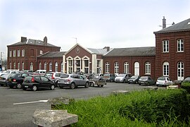
 The railway station in Serqueux | |
| Coordinates: 49°37′57″N 1°32′20″E / 49.6325°N 1.5389°E | |
| Country | France |
| Region | Normandy |
| Department | Seine-Maritime |
| Arrondissement | Dieppe |
| Canton | Gournay-en-Bray |
| Intercommunality | CC 4 rivières |
| Government | |
| • Mayor (2020–2026) | Thomas Hermand[1] |
Area 1 | 5.76 km2 (2.22 sq mi) |
| Population (2021)[2] | 957 |
| • Density | 170/km2 (430/sq mi) |
| Time zone | UTC+01:00 (CET) |
| • Summer (DST) | UTC+02:00 (CEST) |
| INSEE/Postal code | 76672 /76440 |
| Elevation | 137–189 m (449–620 ft) (avg. 170 m or 560 ft) |
| 1 French Land Register data, which excludes lakes, ponds, glaciers > 1 km2 (0.386 sq mi or 247 acres) and river estuaries. | |
Serqueux (French pronunciation: [sɛʁkø]) is a commune in the Seine-Maritime department in the Normandy region in northern France.
Geography
A village situated at the source of the Epte river in the Pays de Bray, some 30 miles (48 km) southeast of Dieppe at the junction of the D 1314, D 13 and D 83 roads. The Serqueux station is an important interchange station for TER regional trains, with connections to Rouen, Amiens, Lille and Gisors. Serqueux has an important plant producing most of the gum arabic in the world. The commune has also an important commercial zone which is by far the biggest in the canton.
History
First mentioned as "Sarkeus" in the twelfth century, the name derives from the Greek sarkofagos, owing to the large Merovingian necropolis in the commune.
Much of the village including the church, was destroyed by Allied bombing during World War II. Nevertheless, the railway station, which was the goal of the bombings, remained untouched.
In 1945, the commune was awarded the Croix de Guerre.
Population
| Year | Pop. | ±% p.a. |
|---|---|---|
| 1968 | 816 | — |
| 1975 | 767 | −0.88% |
| 1982 | 764 | −0.06% |
| 1990 | 853 | +1.39% |
| 1999 | 988 | +1.65% |
| 2007 | 1,061 | +0.90% |
| 2012 | 1,000 | −1.18% |
| 2017 | 991 | −0.18% |
| Source: INSEE[3] | ||
Places of interest
- The modern church, replacing the sixteenth-century one, destroyed during World War II.
- Traces of a feudal castle.
- Ruins of the old church.
See also
References
- ^ "Répertoire national des élus: les maires" (in French). data.gouv.fr, Plateforme ouverte des données publiques françaises. 13 September 2022.
- ^ "Populations légales 2021" (in French). The National Institute of Statistics and Economic Studies. 28 December 2023.
- ^ Population en historique depuis 1968, INSEE
External links
- Serqueux on the Quid website (in French)


