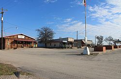
Blue Ridge, Texas
Blue Ridge, Texas | |
|---|---|
 | |
 Location of Blue Ridge in Collin County, Texas | |
| Coordinates: 33°17′57″N 96°24′6″W / 33.29917°N 96.40167°W | |
| Country | United States |
| State | Texas |
| County | Collin |
| Area | |
• Total | 1.11 sq mi (2.89 km2) |
| • Land | 1.11 sq mi (2.89 km2) |
| • Water | 0.00 sq mi (0.00 km2) |
| Elevation | 614 ft (187 m) |
| Population (2020) | |
• Total | 1,180 |
| • Density | 830.49/sq mi (320.71/km2) |
| Time zone | UTC−6 (Central (CST)) |
| • Summer (DST) | UTC−5 (CDT) |
| ZIP Code | 75424 |
| Area code | 972 |
| FIPS code | 48-08872[2] |
| GNIS feature ID | 1352485[3] |
| Website | blueridgecity |
Blue Ridge is a city at the intersection of state highway 78, FM 981, and FM 545 in Collin County, Texas, United States. The population was 822 at the 2010 census, and 1,180 in 2020.[4]
History
Blue Ridge is named for the blue flowers found on the hills around the area by early settlers.[citation needed]
2017 oil pipeline spill
On January 30, 2017, 600,000 gallons of oil spilled from the Seaway Pipeline in Blue Ridge.[5]
Geography
Blue Ridge is located at 33°17′57″N 96°24′6″W / 33.29917°N 96.40167°W (33.299206, –96.401616).[6]
According to the United States Census Bureau, the city has a total area of 1.12 square miles (2.9 km2), all land.
Demographics
| Census | Pop. | Note | %± |
|---|---|---|---|
| 1940 | 424 | — | |
| 1950 | 306 | −27.8% | |
| 1960 | 330 | 7.8% | |
| 1970 | 384 | 16.4% | |
| 1980 | 442 | 15.1% | |
| 1990 | 521 | 17.9% | |
| 2000 | 672 | 29.0% | |
| 2010 | 822 | 22.3% | |
| 2020 | 1,180 | 43.6% | |
| U.S. Decennial Census[7] | |||
At the 2010 census there were 822 people in 284 households, including 210 families, in the city. The population density was 733.9 inhabitants per square mile (283.4/km2). There were 323 housing units at an average density of 288.4 per square mile (111.4/km2). The racial makeup of the city was 92.60% White, 0.4% African American, 0.7% Native American, 2.8% from other races, and 3.4% from two or more races. Hispanic or Latino of any race were 13.1%.[2]
Of the 284 households 39.8% had children under the age of 18 living with them, 54.2% were married couples living together, 15.5% had a female householder with no husband present, and 26.1% were non-families. 22.2% of households were one person and 21.5% were one person aged 65 or older. The average household size was 2.89 and the average family size was 3.38.
The age distribution was 29.4% under the age of 18, 10.7% from 18 to 24, 29.2% from 25 to 44, 21.8% from 45 to 64, and 8.9% 65 or older. The median age was 32.0 years. For every 100 females, there were 87.7 males. For every 100 females age 18 and over, there were 82.4 males.
The median household income was $44,625 and the median family income was $67,250. Males had a median income of $31,250 versus $43,125 for females. The per capita income for the city was $19,522. About 9.8% of families and 15.2% of the population were below the poverty line, including 25.0% of those under age 18 and 46.8% of those age 65 or over; however, the margin of error for these metrics was ±10.2% for families in poverty, and ±26.7% and ±27.8% for under 18 and over 65 in poverty, respectively.
Education
The city of Blue Ridge is served by Blue Ridge Independent School District.
Parks and recreation
Bratcher Park is located on the west side of the town square behind Blue Ridge City Hall.
Blue Ridge is also the home of Parkhill Prairie, a 436-acre Blackland tall-grass prairie preserve located off of Collin County road 668.
References
- ^ "2019 U.S. Gazetteer Files". United States Census Bureau. Retrieved August 7, 2020.
- ^ a b "U.S. Census website". United States Census Bureau. Retrieved January 31, 2008.
- ^ "US Board on Geographic Names". United States Geological Survey. October 25, 2007. Retrieved January 31, 2008.
- ^ "2020 Race and Population Totals". United States Census Bureau. Archived from the original on November 6, 2021. Retrieved November 6, 2021.
- ^ "In Tiny Blue Ridge, Texas, Oil Spill is Cautionary Tale Against Dakota Access Pipeline". February 11, 2017.
- ^ "US Gazetteer files: 2010, 2000, and 1990". United States Census Bureau. February 12, 2011. Retrieved April 23, 2011.
- ^ "Census of Population and Housing". Census.gov. Retrieved June 4, 2015.

