
Ogunquit River
From Wikipedia, the free encyclopedia
This is an old revision of this page, as edited by Ser Amantio di Nicolao (talk | contribs) at 20:10, 10 May 2020 (→References: add authority control). The present address (URL) is a permanent link to this revision, which may differ significantly from the current revision.
Revision as of 20:10, 10 May 2020 by Ser Amantio di Nicolao (talk | contribs) (→References: add authority control)
River in the United States
| Ogunquit River | |
|---|---|
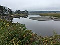
 Ogunquit River in Wells | |
 | |
| Location | |
| Country | United States |
| Physical characteristics | |
| Source | |
| • location | Maine |
The Ogunquit River is a 9.8-mile-long (15.8 km)[1] tidal river in southern Maine. It flows to the Atlantic Ocean at the town of Ogunquit.
Images
-
-
 High tide
 -
 Mid tide
 -
 Low tide


See also
References
- ^ U.S. Geological Survey. National Hydrography Dataset high-resolution flowline data. The National Map Archived 2012-04-05 at WebCite, accessed June 30, 2011
- U.S. Geological Survey Geographic Names Information System: Ogunquit River
- Maine Streamflow Data from the USGS
- Maine Watershed Data From Environmental Protection Agency
43°15′1.2″N 70°35′43.3″W / 43.250333°N 70.595361°W / 43.250333; -70.595361
| Bay of Fundy |
| ||||||||||||||||||||||||||||||
|---|---|---|---|---|---|---|---|---|---|---|---|---|---|---|---|---|---|---|---|---|---|---|---|---|---|---|---|---|---|---|---|
| Casco Bay |
| ||||||||||||||||||||||||||||||
| Gulf of Maine |
| ||||||||||||||||||||||||||||||
| Merrymeeting Bay |
| ||||||||||||||||||||||||||||||
| Muscongus Bay |
| ||||||||||||||||||||||||||||||
| Penobscot Bay |
| ||||||||||||||||||||||||||||||
| Saco Bay |
| ||||||||||||||||||||||||||||||
This article related to a river in Maine is a stub. You can help Wikipedia by expanding it. |
Hidden categories:
- Webarchive template webcite links
- Pages using gadget WikiMiniAtlas
- Articles with short description
- Short description is different from Wikidata
- Infobox mapframe without OSM relation ID on Wikidata
- Pages using infobox river with mapframe
- Coordinates on Wikidata
- All stub articles
- Pages using the Kartographer extension