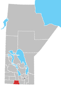
Swan Lake First Nation
Appearance
The Swan Lake First Nation is a Saulteaux band government in Manitoba, Canada. It is located mainly at Indian Reserve 7 with economic initiatives also located at IR 8A. The main reserve is surrounded by the Municipality of Lorne.
External links
References
- ^
Statistics Canada (2012), 2011 Census. Statistics Canada Catalogue no. 92-142-XWE, Ottawa, Ontario (published October 24, 2012), retrieved February 16, 2017
{{citation}}: CS1 maint: location missing publisher (link)
- Swan Lake Development | Developing the comminity, archived from the original on May 22, 2016, retrieved February 15, 2017
- Swan Lake First Nation - Band History[dead link]

