Mangnai
Appearance
Mangnai
茫崖市 (Chinese) ᠮᠠᠨᠭᠨᠠᠢ ᠶᠢᠨ ᠬᠣᠲᠠ (Mongolian) མང་ནེ་གྲོང་ཁྱེར། (Standard Tibetan) Mangyai | |
|---|---|
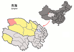
 Magnai / Magnya (light red) within Haixi Prefecture (yellow) and Qinghai | |
| Coordinates: 38°15′00″N 90°51′25″E / 38.250°N 90.857°E | |
| Country | People's Republic of China |
| Province | Qinghai |
| Autonomous prefecture | Haixi |
| Seat | Huatugou |
| Time zone | UTC+8 (China Standard) |
Mangnai also known as Mang'ai or Mangya[1] is a county-level city in the northwest of Qinghai Province, China, bordering Xinjiang to the north and west. It is under the administration of Haixi Mongol and Tibetan Autonomous Prefecture. The Huatugou Airport is located in Mangnai. The former Mangnai and Lenghu administrative zones merged to established the county-level city of Mangnai.
References
- ^ In Central Plains Mandarin it is pronounced Mang-ngai, a transcription of Oirat Mongolian Mangnai. In Standard Mandarin, ngai develops into two different readings with ya the most common one and ai used almost exclusively here. There's a tendency to pronounce it as ya in this situation as well.

