
Nurul Iman Mosque of Koto Gadang
| Nurul Iman Mosque of Koto Gadang | |
|---|---|
Masjid Nurul Iman Koto Gadang | |
 | |
| Religion | |
| Affiliation | Sunni Islam |
| Location | |
| Location | Agam, West Sumatra, Indonesia |
 Shown within Indonesia | |
| Geographic coordinates | 0°19′06.6″S 100°21′26.3″E / 0.318500°S 100.357306°E |
| Architecture | |
| Architect(s) | Yahya Datuk Kayo |
| Type | Mosque |
| Date established | 1856 (first building) 1932 (second building) |
| Destroyed | 28 June 1926 6 March 2007 |
Nurul Iman Mosque of Koto Gadang or Tapi Koto Gadang Mosque is one of the oldest mosques in Indonesia, located in Koto Gadang Nagari, Agam Regency, West Sumatra. This mosque is the largest mosque in Koto Gadang area.
Since its foundation in 1856, the mosque has undergone some form of transformation and several repairs. The earliest mosque, known as the Old Jamik Mosque, was typical of Minangkabau style with cone-shaped tapered roofs. However, the mosque was heavily damaged during the Padang Panjang earthquake in 1926.
A few months after the earthquake, the new mosque was soon built by the initiative of Yahya Datuk Kayo, who was a member of the Volksraad representing Minangkabau, and inaugurated the renewed mosque on February 5, 1932. Designed by Yazid Rajo Mangkuto, the shape of the new mosque building was totally changed from its predecessor. However, the building of the mosque was destroyed again by the earthquake in March 2007. Since then the mosque was restored with the form similar to the pre-earthquake one.
Old building
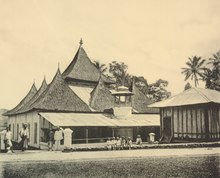
The Old Jamik Mosque was built in 1856.[1][2] Made of wood, the Minangkabau architectural style building was measured 20 × 20 meters.[3] There was also a tower on the roof.[4] The roof had no dome, but consisted of several gonjong roof, a Minangkabau style roof, made of fibers. One gonjong in the middle was flanked by eight smaller gonjong around him.[5]
On June 28, 1926, a magnitude 7.6 earthquake hit Padangpanjang and caused damage to the walls of the mosque.[6] Some of the walls collapsed and the parts still standing were cracked.[3] Dreaded by danger, the building of the mosque was finally dismantled.[7] In a meeting attended by a number of local community leaders on July 18, 1926, it was agreed to immediately establish a new mosque by forming a committee headed by Yahya Datuk Kayo.
See also
References
- Footnotes
- ^ Azizah, dkk 2012, pp. 9.
- ^ Azizah, dkk 2012, pp. 142.
- ^ a b Sura Kota Gadang Tahun X/No.8/Augustus 1926.
- ^ Surya Suryadi & 28 April 2013.
- ^ Azizah, dkk 2012, pp. 53.
- ^ Azizah, dkk 2012, pp. 164.
- ^ Azizah, dkk 2012, pp. 214.
- Bibliography
- Azizah Etek; Mursjid A.M; Arfan B.R. Koto Gadang Masa Kolonial (2007). PT LKiS Pelangi Aksara. ISBN 979-1283-29-X.
- Surya Suryadi. "Sebuah Mesjid di Koto Gadang". Harian Singgalang. 28 April 2013.
- "Gempa 1926 Bag. 4". Soera Kota Gedang Tahoen X/No.8/Augustus 1926.
- Ramadan Kareem. "Nurul Iman Mosque, Koto Gadang - West Sumatera". 2012.


