Pačetin
Pačetin
| |
|---|---|
 | |
  | |
| Coordinates: 45°22′34″N 18°51′04″E / 45.376°N 18.851°E | |
| Country | |
| Region | Slavonia (Podunavlje) |
| County | |
| Municipality | Trpinja |
| Government | |
| • Body | Local Committee |
| Population | |
| • Total | 541 |
| • Households | 202 |
| Postal code | 32222 Bršadin |
| Area code | +385 32 |
| Vehicle registration | VU |
| Official languages | Croatian, Serbian[2] |
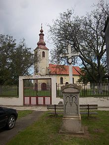
Pačetin (Serbian Cyrillic: Пачетин[4], Hungarian: Pacsinta) is a village in the municipality of Trpinja, Vukovar-Srijem County in the easternmost part of Croatia. At the time of the 2011 Census the population of the village was 541.[3] Village lies north of the Vuka River and west of the M601 railway. Its major landmark is the Church of St. Nicholas from the 18th century. County road Ž4111 passing through the villages of Pačetin, Bobota and Vera connect all three villages with D2 road and D55 road. Pačetin is 28.6 km southeast of Osijek, the economic and cultural centre of Slavonia and 17.2 km from the Osijek Airport. County seat Vukovar is 17.3 km east of Pačetin.
Geography
Absolute altitudes of the village is 87 meters above the sea level.[5] Pačetin is located two kilometers away from the Vuka River.[6]
History
First information about Pačetin come from the 1275.[7] At the place of present day village during the Middle Ages there were three villages with three churches.[7] Louis I of Hungary permitted weekly trade fairs in Pačetin.[7] In 1498 Pačetin gained town status and the medieval Vukovar County Assembly were held in it.[7] After the Ottoman–Hungarian wars and Ottoman conquest of Hungary Pačetin population decreased.[7] After the withdrawal of the Ottoman Empire after the Treaty of Karlowitz of 1666, Pačetin was settled by Serbs mainly from Mačva, eastern Bosnia and Montenegro, and at the beginning of the 18th century, there were over 40 Serbian houses.[7] A century later there were twice as many houses and inhabitants, and at the peak in 1905 there were 1109 inhabitants in Pačetin, of which 1066 were Serbs.[7]
Education

The first records that prove the existence of the school in Pačetin were made on 18 July 1788 which stated that 38 children attended the classes, 19 in the first and second grade, and 76 children at all.[8] This report is today kept in the National Archives of Hungary.[8] Between 1788 until the 1922 there is no records about the school in Pačetin.[8] In 1957 the school was an independent six-year primary school, after that a branch of the elementary school in Nuštar, then branch of the "Braća Đurđević" Elementary School in Vukovar and since 1992 and establishment of SAO Eastern Slavonia, Baranja and Western Syrmia until today it became branch school of the Bobota Elementary School.[8] Branch school of Elementary school Bobota is located in Pačetin, 4,4 kilometers away from mother school in Bobota.[9] Education at local school is implemented in Serbian language.[10] The school building have two classrooms, a kitchen, bathroom and central heating on electrical energy.[9] In 2010 local branch of Prosvjeta published monograph 220 godina školstva u Pačetinu (English: 220 years of schooling in Pačetin).[8]
Population

According to the 1991 census, the village was inhabited by a majority of Serbs (88.48%), and minority of Yugoslavs (6.93%) and Croats (3.17%).[12]
Points of Interest

Church of St. Nicholas in Pačetin is Serbian Orthodox church famous for its iconostasis from 1910. The church is dedicated to St. Nicholas. The building of the St. Nicholas Church in Pačetin started in 1752 and the construction works were finished in three years period so that it was blessed in 1755.
Associations and Institutions
Cultural and Artistic Association Branko Radičević is active in village since 1999.[13] Local drama group, children drama group and reciting section are active as a part of Association.[13] They are organizers of MESDI-International Meetings of Drama Amateurs and Saint Sava Oration.[13]
Sport
- Football club NK Sloga Pačetin
- Chess club "Šahovski klub Sloga Pačetin"
Notable natives and residents
Gallery
See also
References
- ^ "Statut Općine Trpinja" (PDF). Retrieved 25 May 2015.
- ^ a b Government of Croatia (October 2013). "Peto izvješće Republike Hrvatske o primjeni Europske povelje o regionalnim ili manjinskim jezicima" (PDF) (in Croatian). Council of Europe. p. 36. Retrieved 30 November 2016.
- ^ a b c "Population by Age and Sex, by Settlements, 2011 Census: Pačetin". Census of Population, Households and Dwellings 2011. Zagreb: Croatian Bureau of Statistics. December 2012.
- ^ "Minority names in Croatia:Registar Geografskih Imena Nacionalnih Manjina Republike Hrvatske" (PDF). Archived from the original (PDF) on 2013-10-29. Retrieved 2013-03-08.
- ^ "Pačetin". Hrvatska enciklopedija. 4 May 2018. Archived from the original on 4 July 2018. Retrieved 3 July 2018.
- ^ Marković, M. (2003). Istočna Slavonija: Stanovništvo i naselja. Naklada Jesenski i Turk. Zagreb.
- ^ a b c d e f g Sekulić, Srđan (4 May 2018). "Hramovi posvećeni svetom Nikolaju Mirlikijskom – Pačetin, Jagodnjak i Mikluševci". Archived from the original on 3 July 2018. Retrieved 3 July 2018.
- ^ a b c d e Bošnjak, Dragana (13 May 2010). "220 godina pačetinskog školstva". Novosti (Croatia). Archived from the original on 3 July 2018. Retrieved 3 July 2018.
- ^ a b "Osnovna škola Bobota-o školi". Retrieved 2 August 2015.
- ^ Popis osnovnih i srednjih škola s nastavom na jeziku i pismu nacionalnih manjina po modelu A, školska godina 2011./2012., Ministarstvo znanosti obrazovanja i sporta
- ^ Naselja i stanovništvo Republike Hrvatske 1857.-2001., Croatian Bureau of Statistics
- ^ "попис становништва 1991" (PDF). Савезни завод за статистику и евиденцију ФНРЈ и СФРЈ.
- ^ a b c "Općina Trpinja-Kulturna udruženja". Retrieved 2 August 2015.


