Mualim Island
Appearance
 Duke of York Islands | |
| Geography | |
|---|---|
| Location | Oceania |
| Coordinates | 4°13′00″S 152°28′00″E / 4.21667°S 152.46667°E |
| Archipelago | Duke of York Islands |
| Total islands | 13 |
| Major islands | Duke of York Island, Papua New Guinea |
| Administration | |
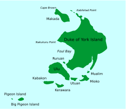
Mualim is island in Duke of York Islands archipelago in Papua New Guinea.[1][2] It is located in the east of the country, in the East New Britain Province, about 800 km to the east of the Port Moresby. The island is populated.[3][4][5]
References
- ^ Mualim Island: Papua New Guinea National Geospatial-Intelligence Agency, Bethesda, MD, USA
- ^ Office, United States Hydrographic (1916). Pacific Islands Pilot. U.S. Government Printing Office.
- ^ Papuan man involved in a Duk duk ceremony in the Tarayu Gettymiages.
- ^ Mualim island Stock Photos and Images
- ^ Papua New Guinea Bismarck Archipelago Gazelle peninsula New Britain island East New Britain province Rabaul Duke of York Archipelago Mualim island women making traditionnal pandanus nats

