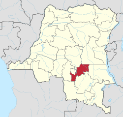
Lomami Province
Lomami | |
|---|---|
| Province de Lomami | |
 | |
| Coordinates: 06°08′S 24°29′E / 6.133°S 24.483°E | |
| Country | |
| Region | Kasai region |
| Established | 2015 |
| Named for | Lomami River |
| Capital | Kabinda |
| Largest city | Mwene Ditu |
| Government | |
| • Governor | Sylvain Lubamba Mayombo[1] |
| Area | |
| • Total | 56,426 km2 (21,786 sq mi) |
| • Rank | 22nd |
| Population (2015) | |
| • Total | 2,048,839 |
| • Rank | 15th |
| • Density | 36/km2 (94/sq mi) |
| Languages | |
| • Official | French |
| • National | Tshiluba |
| Time zone | UTC+02:00 (CAT) |
| Website | provincelomami |
Lomami is one of the 21 new provinces of the Democratic Republic of the Congo created in the 2015 repartitioning. Lomami, Kasaï-Oriental, and Sankuru provinces are the result of the dismemberment of the former Kasaï-Oriental province.[2] Lomami was formed from the Kabinda district and the independently administered city of Mwene-Ditu. The town of Kabinda was elevated to capital city of the new province.
See also
References
- ^ "Congo (Kinshasa) provinces". Rulers. Retrieved 8 July 2019.
- ^ "RDC : le Kasaï-Oriental éclate en trois nouvelles provinces". Radio Okapi (in French). 16 July 2015. Archived from the original on 18 July 2015. Retrieved 3 June 2020.
