
Moers
This article needs additional citations for verification. (October 2013) |
Moers | |
|---|---|
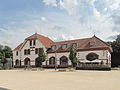
 Moers Castle (2014) | |
 Coat of arms | |
Location of Moers within Wesel district  | |
 Moers  Moers | |
| Coordinates: 51°27′33″N 6°37′11″E / 51.45917°N 6.61972°E | |
| Country | Germany |
| State | North Rhine-Westphalia |
| Admin. region | Düsseldorf |
| District | Wesel |
| Subdivisions | 3 |
| Government | |
| • Mayor | Christoph Fleischhauer (CDU) |
| Area | |
| • Total | 67.68 km2 (26.13 sq mi) |
| Elevation | 23 m (75 ft) |
| Population (2022-12-31)[1] | |
| • Total | 105,287 |
| • Density | 1,600/km2 (4,000/sq mi) |
| Time zone | UTC+01:00 (CET) |
| • Summer (DST) | UTC+02:00 (CEST) |
| Postal codes | 47441 - 47447 |
| Dialling codes | 0 28 41 |
| Vehicle registration | MO (alternative: WES or DIN) |
| Website | www |

You can help expand this article with text translated from the corresponding article in German. (March 2020) Click [show] for important translation instructions.
|
Moers (German pronunciation: [ˈmœʁs] ⓘ; older form: Mörs; archaic Dutch: Murse, Murs or Meurs) is a German city on the western bank of the Rhine. Moers belongs to the district of Wesel.
History

Known earliest from 1186, the county of Moers was an independent principality within the Holy Roman Empire.
During the Eighty Years' War it was alternately captured by Spanish and Dutch troops, as it bordered the Upper Quarter of Guelders. During the war it finally fell to Maurice of Orange. As it was separated from the Dutch Republic by Spanish Upper Guelders it did not become an integral part of the Republic, though Dutch troops were stationed there.
After the death of William III of Orange in 1702, Moers was inherited by the king of Prussia. All Dutch troops and civil servants were expelled.
In 1795 it was annexed by France. At the Congress of Vienna, in 1815 it was returned to Prussia and in 1871 it became part of the German Empire.
A target of the Oil Campaign of World War II, the Steinkohlenbergwerke (English: coal mine) Rheinpreussen synthetic oil plant in Moers,[2] was partially dismantled post-war.
| Significant minority groups | |
| Nationality | Population (2014) |
|---|---|
| 4,245 | |
| 725 | |
| 586 | |
| 427 | |
| 327 | |
Gallery
-
 Moers, churchtower (die evangelische Stadtkirche) in the street
 -
 Moers, station
 -
 Moers, monumental building: das Ärtzehaus
 -
 Moers c1591


Mayors
- 1815–1820: Wilhelm Urbach
- 1822–1830: von Nievenheim
- 1830–1850: Friedrich Adolf Vinmann
- 1850–1859: Karl von Strampff
- 1860–1864: Gottlieb Meumann
- 1864–1897: Gustav Kautz
- 1898–1910: August Craemer
- 1910–1915: Dr. Richard Glum
- 1917–1937: Dr. Fritz Eckert
- 1937–1941: Fritz Grüttgen
- 1943–1945: Peter Linden
- 1945–1946: Dr. Otto Maiweg
- 1946: Karl Peschken
- 1946–1952: Wilhelm Müller
- 1952–1977: Albin Neuse (SPD)
- 1977–1999: Wilhelm Brunswick (SPD)
- 1999–2004: Rafael Hofmann (CDU)
- 2004–2014: Norbert Ballhaus (SPD)
- 2014–: Christoph Fleischhauer (CDU)
Sports
In 1985, the Moers Sports Club (volleyball) was formed, winning the 1989 Bundesliga championship.
Notable people

- Gerhard Tersteegen (1697-1769), lay preacher, mystic and poet ("I pray to the power of love")
- Georg Perthes (1869-1927), surgeon and radiologist (Perthes disease)
- Anna Erler-Schnaudt (1878–1963), contralto
- Hans Dammers (1913-1944), German Luftwaffe ace
- Walter Niephaus (1923-1992), chess player
- Hanns Dieter Hüsch (1925-2005), comedian, writer
- Hubert Hahne (born 1935), race car driver
- Herman Weigel (born 1950), film producer and screenwriter
- Ljubisa Racic (born 1954), Bosnian guitar player, founder of ex-yu rock band formula 4
- Jürgen Renn (born 1956), physicist and historian of science
- Helga Trüpel (born 1958), politician (Alliance '90 / The Greens)
- Jörg van Ommen (born 1962), race car driver
- Katja Nass (born 1968), fencer
- Stephan Paßlack (born 1970), former German international football player
- Christian Ehrhoff (born 1982), professional ice hockey player
- Timo Weß (born 1982),field hockey player and member of the Men's National Team
- Benjamin Weß (born 1985), field hockey player and former member of the Men's National Team
International relations
Moers is twinned with:
1966 ![]() Maisons-Alfort
Maisons-Alfort
1974 ![]() Bapaume
Bapaume
1980 ![]() Knowsley (Liverpool City Region)
Knowsley (Liverpool City Region)
1987 ![]() Ramla
Ramla
1989 ![]() La Trinidad, Nicaragua
La Trinidad, Nicaragua
1990 ![]() Seelow (Brandenburg)
Seelow (Brandenburg)
See also
- Moers Festival
- Burma-Shave, which awarded a trip to Moers in a 1955 promotion
References
- ^ "Bevölkerung der Gemeinden Nordrhein-Westfalens am 31. Dezember 2022 – Fortschreibung des Bevölkerungsstandes auf Basis des Zensus vom 9. Mai 2011" (in German). Landesbetrieb Information und Technik NRW. Retrieved 20 June 2023.
- ^ "Index - Tom Reel 304 : Documents taken from Steinkohlenbergwerk Rheinpreussen, Moers" (PDF). Fischer-tropsch.org. Archived from the original (PDF) on 2013-10-18. Retrieved 2013-10-17.
External links
Towns and municipalities in Wesel (district) | ||
|---|---|---|
 | ||
| International | |
|---|---|
| National | |
| Geographic | |
| Other | |