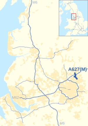
A627(M) motorway
| A627(M) | ||||
|---|---|---|---|---|
 | ||||
 Looking towards the M62 junction | ||||
| Route information | ||||
| Maintained by National Highways | ||||
| Length | 3.5 mi[1] (5.6 km) | |||
| Existed | 1972–present | |||
| Major junctions | ||||
| North end | Rochdale | |||
M62 motorway | ||||
| South end | Chadderton | |||
| Location | ||||
| Country | United Kingdom | |||
| Road network | ||||
| ||||
The A627(M) is a motorway that runs between Chadderton and Rochdale in Greater Manchester, England. It is 3.5 miles (5.6 km) long and connects the two towns to the M62. It opened in 1972.[2]
Route
[edit]Heading north, the road starts as a two-lane dual carriageway on the A663 at Chadderton. It turns sharply left and passes west of Royton. It continues to its next junction, where it has a 1-mile (1.6 km) spur. Although signed as the A627(M), a map exists showing it as the A6138(M).[citation needed] After this junction it gains a third lane, before reaching a roundabout at the M62 junction 20. This junction has been designed to accommodate a future flyover.[citation needed] After crossing the roundabout, the route continues as a dual two-lane route for another 1 mi (1.6 km) before turning sharp right to reach its terminal crossroads.
Junctions
[edit]This section contains a bulleted list or table of intersections which should be presented in a properly formatted junction table. (December 2021) |
Note: motorway has no junction numbers
| A627(M) motorway | ||
| Northbound exits | Junction | Southbound exits |
| Lower Place, Milnrow A664 Rochdale, Sudden (A58) |
Terminus | Start of motorway |
| Bolton, Manchester M62 Leeds, Hull M62 |
M62 J20 | Leeds, Hull M62 Bolton, Manchester M62 |
| Castleton, Middleton (A664) | Castleton, Middleton (A664) | |
| Start of motorway | Oldham A627 Royton, Shaw A663 | |
| Road continues as A663 towards Manchester and Failsworth | ||
See also
[edit]References
[edit]- ^ "Directions to A627(M)". Google Maps. Google. Retrieved 13 May 2013.
- ^ CBRD Motorway Archive – A627(M)
External links
[edit]![]() Geographic data related to A627(M) motorway at OpenStreetMap
Geographic data related to A627(M) motorway at OpenStreetMap


