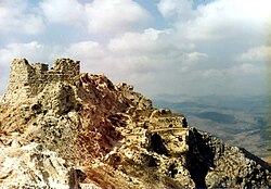
Beaufort Castle, Lebanon


Beaufort or Belfort (Arabic: قلعة الشقيف, Qala'at ash-Shqif, Hebrew: מבצר הבופור, Mivtsār hāBōfōr) is a Crusader fortress in Nabatiye Governorate, southern Lebanon, about 1 kilometer (0.62 miles) to the south-south-west of the village of Arnoun.
The castle was named "bel fort" or "beau fort" (French for "beautiful fortress") by the Crusaders who occupied the castle in the 12th century. Its Arabic name Qala'at ash-Shqif means Castle of the High Rock in the Syrian Arabic dialect (shqif is the Aramaic word for "high rock"). The castle's full name in Arabic is قلعة الشقيف ارنون (Qala'at ash-Shqif Arnoun), a combination of the Arabic word Qala'at (castle) and the Aramaic Shqif Arnoun.
The castle is also sometimes referred to as Beaufort Castle in Arabic (قصر البوفورت, Qasr al-Bofort).
Ancient History
Little is known of the site prior to its capture by Crusader forces in 1139 AD, although historians assume that the castle's commanding position atop a 700 metre (2,100 feet) hill made it a strategic position even in Biblical and Roman times[1], and that there was already an existing structure at the time.
After its capture by King Fulk, the castle was handed over to the lords of Sidon. In 1189, Saladin laid siege to it, while Reginald of Sidon was defending the stronghold. He could by ruse delay the capture, but the castle was finally taken by Saladin in 1190 AD. The Crusaders took the castle back in 1240, then it was sold to the Knights Templar by Reginald's grandson, Julian of Sidon, in 1260. In 1268, the Mamluke Sultan Baibars captured the castle, and there was relative calm through the 14th, 15th and 16th centuries.
In the 17th century Fakhr-al-Din II took the castle as a part of his network of fortifications. Fakhr-al-Din II was defeated by the Ottomans, who destroyed the upper portions of the castle. The area was ruled by feudal families until 1769.
Modern History

In 1782 the Governor of Acre besieged the castle, captured it and destroyed many of its remaining fortifications. An earthquake in 1837 destroyed many parts of the castle, and it was used as a quarry and a shelter for sheep.
Restoration of the castle began with the French Mandate over Lebanon in 1920, and continued with Lebanese independence in 1943.
The castle's strategic location, which affords a view of much of southern Lebanon and northern Israel, has caused it to be a focus for recent conflicts.
From 1976 onwards, (during the Lebanese Civil War), the castle was held by the Palestine Liberation Organization (PLO), which used the castle to fire rockets into northern Israel[2]. Between 1976 and 1980 PLO positions on the castle were attacked dozens of times by Israeli forces.
On June 6, 1982, at the start of Operation Peace for Galilee (the 1982 Lebanon War), the PLO position on the Beaufort Castle was heavily shelled before being captured by the Israeli Defense Forces (IDF) on June 7, 1982.
Between 1982 and 2000, the Beaufort Castle and surrounding areas were used as a base and observation post by the IDF. The IDF fortified the area with bunkers and concrete blocks. The Israeli position at the castle was attacked a number of times by Hezbollah.
In May 2000, the IDF evacuated their Security Zone in Southern Lebanon, leaving the castle and destroying IDF infrastructure, so that it could not be used by Hezbollah, thus damaging parts of the historic castle[2][3].
In 2007, an Israeli Oscar-nominated movie, Beaufort directed by Joseph Cedar, was released. It related a fictional account of the last weeks of occupation of the Beaufort outpost by the Israeli army.
Sources
- "The Restoration of Beaufort Castle (South Lebanon) A 3D Restitution According to Historical Documentation", Pierre Grussenmeyer, Jean Yasmine, Lebanese Directorate General of Antiquities (accessed September 5, 2006)
- Hugh Kennedy, Crusader Castles, Cambridge 1994.
- David Nicolle, Crusader Castles in the Holy Land 1097-1192, Oxford 2004.
- R. C. Smail, Crusading Warfare 1097-1193, Cambridge 1956.
