Bohnsdorf
Bohnsdorf | |
|---|---|
 Church and lake in Bohnsdorf | |
| Coordinates: 52°24′00″N 13°34′00″E / 52.40000°N 13.56667°E | |
| Country | Germany |
| State | Berlin |
| City | Berlin |
| Borough | Treptow-Köpenick |
| Founded | 1375 |
| Subdivisions | 2 zones |
| Area | |
• Total | 6.52 km2 (2.52 sq mi) |
| Elevation | 34 m (112 ft) |
| Population (2023-12-31)[1] | |
• Total | 13,685 |
| • Density | 2,100/km2 (5,400/sq mi) |
| Time zone | UTC+01:00 (CET) |
| • Summer (DST) | UTC+02:00 (CEST) |
| Postal codes | 12524, 12526 |
| Vehicle registration | B |
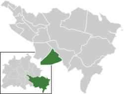
Bohnsdorf (German: [ˈboːnsˌdɔʁf] ) is a district in the borough Treptow-Köpenick of Berlin, Germany. It is located in the south-east of the city.
History
[edit]The locality was first mentioned in 1375 with the name of Benistorp.
Geography
[edit]Position
[edit]The locality is situated in the southeastern suburb of Berlin and borders with Altglienicke, Grünau, and with the municipality of Schönefeld, in the Brandenburg district of Dahme-Spreewald. Close to the village lies Berlin Brandenburg Airport. Previously when the airport was known as Berlin Schönefeld Airport before Brandenburg's construction the former runway 07L/25R ended near Bohnsdorf.
Trivia
[edit]Bohnsdorf gained some notoriety for its unsolvable traffic problems with the Bohnsdorfer Kreisel.[2]
Parts
[edit]Bohnsdorf is not divided into zones. Parts of Bohnsdorf are (no subdivision)
- Falkenberg (north part)
- Falkenhorst (south-east part)
Personalities
[edit]References
[edit]External links
[edit]![]() Media related to Bohnsdorf at Wikimedia Commons
Media related to Bohnsdorf at Wikimedia Commons


