Bundesautobahn 8
| A 8 | ||
|---|---|---|
| Bundesautobahn 8 | ||
 | ||
| Route information | ||
| Length | 497 km (309 mi) | |
| Major junctions | ||
| From | Luxembourg A13 motorway | |
class="wikitable "
| ||
| To | Austrian West Autobahn near Salzburg | |
| Location | ||
| Country | Germany | |
| States | Saarland, Rhineland-Palatinate, Baden-Württemberg, Bavaria | |
| Highway system | ||
| ||
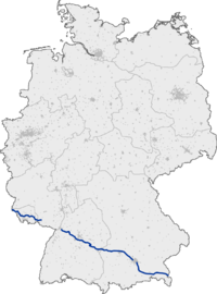
Bundesautobahn 8 (translates from German as Federal Motorway 8, short form Autobahn 8, abbreviated as BAB 8 or A 8) is an autobahn in southern Germany that runs 497 km (309 mi) from the Luxembourg A13 motorway at Schengen via Neunkirchen, Pirmasens, Karlsruhe, Stuttgart, Ulm, Augsburg and Munich to the Austrian West Autobahn near Salzburg.

The A 8 is a significant East-West transit route. Its construction began in March 1934 during Nazi rule, the section between Karlsruhe and Salzburg having been completed when road works discontinued in World War II. Although parts have been modernized and extended afterwards, significant sections remained in their original condition from the 1930s - 2+2 lanes, no emergency or acceleration lanes, steep hills and tight curves. In combination with today's traffic this makes the A 8 one of the most crowded and dangerous autobahns in Germany. Especially in the wintertime the slopes of the Black Forest, the Swabian Alb near Aichelberg, as well as the Irschenberg become bottlenecks when heavy trucks crawl uphill.
Plans
As of 2012[update], a gap remains between Pirmasens and Karlsruhe with no immediate plans to close the gap. Additionally, there are plans to re-route a sub-standard section between Aichelberg and Hohenstadt. It is proposed that tolls be charged on this tunnel-oriented replacement stretch (presumably to cover the costs of the project), which would make it the first tolled section of a German autobahn.
External links
 Geographic data related to Bundesautobahn 8 at OpenStreetMap
- Bundesautobahn 8 – detailed route plan (in German)
48°05′41″N 11°36′53″E / 48.09459°N 11.61461°E


