Edgemere, Queens
Edgemere | |
|---|---|
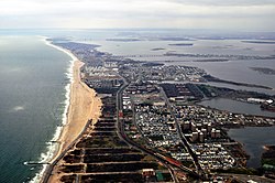
 Aerial view of Edgemere, looking west. | |
 Location within New York City | |
| Coordinates: 40°35′42″N 73°46′30″W / 40.595°N 73.775°W | |
| Country | |
| State | |
| City | |
| County/Borough | |
| Community District | Queens 14[2] |
| Named for | "Edge of the sea"[3] |
| Population (2019) | |
| • Total | 18,100 [1] |
| Race and Ethnicity | |
| • Non-Hispanic White | 7% |
| • Black or African-American | 56% |
| • Hispanic or Latino of any race | 32% |
| • Asian | 2% |
| • other | 3% |
| Economics | |
| • Median income | $32,785 [1] |
| Time zone | UTC−5 (EST) |
| • Summer (DST) | UTC−4 (EDT) |
| ZIP Code | 11691 |
| Area codes | 718, 347, 929, and 917 |


Edgemere is a neighborhood in the New York City borough of Queens, extending from Beach 32nd to Beach 52nd Street on the Rockaway Peninsula. It contains Rockaway Community Park.[4] Arverne is to the west, and Far Rockaway to the east. Edgemere was founded in 1892 by Frederick J. Lancaster, who originally called it New Venice.[5][3]
Edgemere is located in Queens Community District 14 and its ZIP Code is 11691.[2] It is patrolled by the New York City Police Department's 101st Precinct.
Much like neighboring Arverne, Edgemere was developed as a beachfront tourist district with easy access to Brooklyn and Manhattan by railway. After World War II, the late 19th and early 20th century resorts and cheap bungalows that lined the boardwalk were considered outdated and undesirable by city officials. East of Beach 32nd Street, the original pattern of development can still be seen: rows of very small, single-story bungalows packed close together on narrow streets. As part of an urban renewal project, nearly all structures south of Rockaway Freeway, from Beach 32nd Street to Beach 90th Street, were acquired and demolished by 1970. Despite many ambitious plans for proposed development, no construction occurred until after 1984 and the coastline of Edgemere and Arverne remained lined with hundreds of acres of vacant wasteland for decades.[6] Arverne has since been redeveloped, but the coastal section of Edgemere remains entirely vacant.
References
- ^ a b "Edgemere, Queens" (PDF). New York City Office of Environmental Remediation. Retrieved June 6, 2021.
- ^ a b "NYC Planning | Community Profiles". communityprofiles.planning.nyc.gov. New York City Department of City Planning. Retrieved April 7, 2018.
- ^ a b Jackson, Kenneth T., ed. (2010). The Encyclopedia of New York City (2nd ed.). New Haven: Yale University Press. p. 1913. ISBN 978-0-300-11465-2.
- ^ Rockaway Community Park NYC Parks
- ^ The Rockaways. Accessed October 2, 2007. "Edgemere was developed by Frederick J. Lancaster in 1892. The area was a sandy waste, with only two or three houses and the Half-Way House. Mr. Lancaster called the place New Venice."
- ^ "Ărverne Housing Beset By Delays". The New York Times. 1970-12-20. ISSN 0362-4331. Retrieved 2023-08-29.
External links

