Jump to content

Feni Islands

Coordinates: 4°05′00″S 153°42′00″E / 4.083333°S 153.7°E / -4.083333; 153.7
From Wikipedia, the free encyclopedia

This is an old revision of this page, as edited by Davidcannon (talk | contribs) at 01:14, 1 September 2015 (External links: clean up using AWB). The present address (URL) is a permanent link to this revision, which may differ significantly from the current revision.

Feni Islands seen from space. Ambitle (larger) and Babase (smaller).

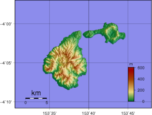
Feni Islands is an island group in Papua New Guinea, located east of New Ireland, at 4°05′00″S 153°42′00″E / 4.083333°S 153.7°E / -4.083333; 153.7. It is a part of Bismarck Archipelago. Largest island of the group is Ambitle, other islands include Babase Island.

Topographic map of Feni Islands.