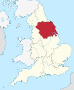
Foss Island Power Station
Appearance
| Foss Islands Power Station | |
|---|---|
 | |
 | |
| Country | England |
| Location | North Yorkshire, Yorkshire and the Humber |
| Coordinates | 53°58′N 1°04′W / 53.96°N 1.07°W |
| Commission date | 1900 |
| Decommission date | 1976 |
| Operator | Central Electricity Generating Board |
| Thermal power station | |
| Primary fuel | Coal |
| Power generation | |
| Nameplate capacity |
|
Foss Island Power station was a small coal-fired power station serving the city of York.[1]
It was located in the Layerthorpe area of the city,[2] to the east of the city centre.
It was built by York Corporation in the 1890s, opened in February 1900[3] and closed 25 October 1976.[4] The buildings were demolished around 1980. The transmission line which ran from the power station to a substation at Tang Hall Lane was dismantled at around the same time.
References
- ^ Jackson, Jeffrey (10 August 1961). "Why Boliers Corrode". New Scientist. No. 247. p. 334. Retrieved 17 January 2016.
- ^ "The Derwent Valley Railway". www.irsociety.co.uk. Retrieved 17 January 2016.
- ^ "Public services British History Online". www.british-history.ac.uk. Retrieved 17 January 2016.
- ^ "Coal-fired Power Stations (Hansard, 16 January 1984)". hansard.millbanksystems.com. Retrieved 17 January 2016.

