Gal'ed
Gal'ed | |
|---|---|
 | |
| Coordinates: 32°33′23″N 35°4′37″E / 32.55639°N 35.07694°E | |
| Country | Israel |
| District | Northern |
| Council | Megiddo |
| Affiliation | Kibbutz Movement |
| Founded | 1945 |
| Founded by | German Jews |
| Population (2022)[1] | 491 |
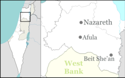
Gal'ed (Hebrew: גַּלְעֵד, lit. 'Monument') is a kibbutz in northern Israel. Located in the Menashe Heights with an area of 14,500 dunams, it falls under the jurisdiction of Megiddo Regional Council. In 2022 it had a population of 491.[1]
History
[edit]Kibbutz Gal'ed was established in 1945 by a gar'in of German HaBonim members which had formed in 1938. Because the land on which the kibbutz lies was bought with money donated by Isaac (Yitzhak) Ochberg (1879–1938), a South African philanthropist, Keren HaYesod wanted the kibbutz named "Even Yitzhak" (lit. 'Stone of Yitzhak'). However, eventually the kibbutz members had their way and the kibbutz was named Gal'ed (lit. 'monument or memorial') to commemorate friends and family of the founders who had died in the Holocaust.[2] The land had traditionally belonged to the Palestinian village of Al-Butaymat, which was depopulated in 1948.[3]
Amongst the founders were the couple Giora and Senetta Yoseftal, both of whom were later members of the Knesset, with Giora serving in several ministerial portfolios.[4]
References
[edit]- ^ a b "Regional Statistics". Israel Central Bureau of Statistics. Retrieved 21 March 2024.
- ^ "קיבוץ גלעד – תעודת זהות". Gal'ed.
- ^ Khalidi, Walid (1992). All That Remains: The Palestinian Villages Occupied and Depopulated by Israel in 1948. Washington D.C.: Institute for Palestine Studies. p. 157. ISBN 0-88728-224-5.
- ^ Giora Yoseftal: Public Activities Knesset

