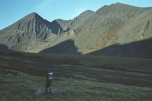
Hag's Tooth, Kerry
| The Hag's Tooth | |
|---|---|
 Looking back down into the Hag's Glen having walked passed the distinctive, Hag's Tooth | |
| Highest point | |
| Elevation | 650 m (2,130 ft) |
| Prominence | 15 m (49 ft) |
| Listing | Vandeleur-Lynam |
| Coordinates | 52°00′19″N 9°44′03″W / 52.0052°N 9.734229°W |
| Naming | |
| Native name | Stumpa an tSaimh |
| English translation | Stump of the sorrel |
| Geography | |
| Location | County Kerry, Ireland |
| Parent range | MacGillycuddy's Reeks |
| OSI/OSNI grid | V809850 |
| Topo map | OSI Discovery 78 |
| Geology | |
| Mountain type | Well-bedded grey sandstone Bedrock |
The Hag's Tooth (Irish: Stumpa an tSaimh, meaning 'stump of the sorrel'),[1] at 650 metres (2,130 ft) high, is a sharp rock spike which is the 193rd highest peak in Ireland on the Vandeleur-Lynam scale. It is also known as Stumpeenadaff (Irish: Stuimpín an Daimh, meaning 'little pinnacle of the ox').[1] The Hag's Tooth is situated in the Hag's Glen beside the Eagle's Nest corrie of Carrauntoohil and is part of the MacGillycuddy's Reeks in County Kerry.
Geography
[edit]
The Hag's Tooth is a distinctive triangular rock feature encountered when walking through the Hag's Glen on the way to climbing Carrauntoohil 1,038.6 metres (3,407 ft), Ireland's highest mountain, via the classic Devil's Ladder route.[2] The Hag's Tooth rock is described as "remarkably unstable".[3]
The steep and narrow rocky ridge from the Hag's Tooth up to the summit of Beenkeragh, is referred to as the Hag's Tooth Ridge (see photo opposite).[4]
Because of the low prominence of the Hag's Tooth, it only qualifies as a mountain on the Vandeleur-Lynam classification—Irish peaks over 600 m (2,000 ft), and with prominence over 15 m (49 ft); a threshold that the Hag's Tooth just meets.[5]
The Hag's Tooth does not appear in the MountainViews Online Database, 100 Highest Irish Mountains, as the prominence threshold is 100 m (328 ft).[6][7]
Climbing
[edit]
The route to the Hag's Tooth follows the same path to access the Heavenly Gates gully of Carrauntoohil (the Heavenly Gates are sometimes used as an alternative descent route to the Devil's Ladder from the summit of Carrauntoohil), and also to access the dramatic deep corrie at the base of Carrauntoohil's north-east face, known as the Eagle's Nest area.[2][8] The Eagle's Nest corrie consists of three distinct levels, with the top level containing Lough Cummeenoughter, Ireland's highest lake.[9]
The narrow rocky ridge from the Hag's Tooth up to the summit of Beenkeragh, the Hag's Tooth Ridge, is regarded for its scrambling, and for its views into the Eagle's Nest area and the major gullies of Carrauntoohil's north-east face.[10] The route also enables loop to be completed by continuing across the infamous Beenkeragh Ridge to Carrauntoohil, and then descending via the Heavenly Gates, back into the Hag's Glen.[2] However, it is also a dangerous route and has been the scene of accidents.[11]
See also
[edit]- Lists of mountains in Ireland
- List of mountains of the British Isles by height
- List of Furth mountains in the British Isles
References
[edit]- ^ a b Tempan, Paul (February 2012). "Irish Hill and Mountain Names" (PDF). MountainViews.ie.
- ^ a b c Ryan, Jim (2006). Carrauntoohil and MacGillycuddy's Reeks: A Walking Guide to Ireland's Highest Mountains. Collins Press. ISBN 978-1905172337.
- ^ Stewart, Simon (2018). "Hag's Tooth". MountainViews Online Database.
The rock is remarkably unstable on the western slopes and boulders can tumble down unexpectedly.
- ^ "Corrauntoohil via the Hag's Tooth Ridge". Kerryclimbing.ie. 2017.
- ^ "Vandeleur-Lynams: Irish mountains of 600+m with a prominence of 15m". MountainViews Online Database. October 2018.
- ^ "Irish Highest 100: The highest 100 Irish mountains with a prominence of +100m". MountainViews Online Database. September 2018.
- ^ Mountainviews, (September 2013), "A Guide to Ireland's Mountain Summits: The Vandeleur-Lynams & the Arderins", Collins Books, Cork, ISBN 978-1-84889-164-7
- ^ Dwyer, John (5 June 2010). "Plenty of bite in the Hag's Tooth". Irish Times.
- ^ Fairborn, Helen (30 June 2018). "Fancy a swim in Ireland's highest lake, halfway up Carrauntoohil?". Irish Times.
Located at an elevation of 707m, Lough Cummeenoughter in Co Kerry is a unique swimming spot. Not only is this the highest lake in Ireland, it's also one of the most dramatic. Nestled at the base of a natural amphitheatre with the country's two tallest peaks towering on either side, Irish swimming doesn't come any wilder than this. The lake itself is surprisingly hospitable; it has a sandy bed and becomes deep quickly enough to dive into.
- ^ "CARRAUNTOOHIL ROUTE DESCRIPTIONS: BROTHER O'SHEA'S GULLY (LOUGH CUMMEENOUGHTER) ROUTE". Kerry Mountain Rescue. 2018.
- ^ Gataveckaite, Gabija (12 May 2019). "Kerry Mountain Rescue send sympathies to family of deceased Carrauntoohil climber". Irish Independent. Retrieved 13 May 2019.
It's believed he fell some 650 feet from the Hag's Tooth Ridge in the Beenkeragh Ridge near Carrauntoohil in the MacGillycuddy's Reeks in county Kerry.
External links
[edit]- MountainViews: The Irish Mountain Website
- MountainViews: Irish Online Mountain Database
- The Database of British and Irish Hills , the largest database of British Isles mountains ("DoBIH")
- Hill Bagging UK & Ireland, the searchable interface for the DoBIH
- Ordnance Survey Ireland ("OSI") Online Map Viewer
- Logainm: Placenames Database of Ireland


