Harrison, Indiana
Appearance
Harrison | |
|---|---|
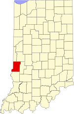
 Vigo County's location in Indiana | |
| Country | |
| State | |
| County | Vigo County |
| Township | Fayette Township |
| Elevation | 140 m (459 ft) |
| Area code | 812 |
| GNIS feature ID | 452218[1] |
Harrison is an unincorporated community in southeastern Fayette Township, Vigo County, Indiana, United States. It is part of the Terre Haute metropolitan area.
History
Harrison was platted August 4, 1837, by Ann Potts, on the west side of the river from Fort Harrison, a military outpost in the region built in 1811 by General William Henry Harrison.[2][3]
Geography
Harrison is located at 39°31′43″N 87°25′20″W / 39.52861°N 87.42222°W at an elevation of 459 feet.
References
- ^ "Harrison". Geographic Names Information System. United States Geological Survey, United States Department of the Interior. Retrieved 2010-06-25.
- ^ "Fort Harrison (historical)". Geographic Names Information System. United States Geological Survey, United States Department of the Interior. Retrieved 2010-06-25.
- ^ Bradsby, H.C. (1891). History of Vigo County, Indiana, with Biographical Selections. Chicago: S. B. Nelson & Co. p. 476.
{{cite book}}: Cite has empty unknown parameter:|coauthors=(help)

