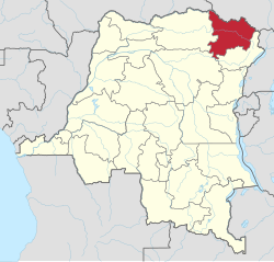
Haut-Uélé
Appearance
Haut-Uele Province | |
|---|---|
 | |
| Country | |
| Capital | Isiro |
| Largest city | Isiro |
| Government | |
| • Governor | Jean-Pierre Lola Kisanga[1] |
| Area | |
| • Total | 89,683 km2 (34,627 sq mi) |
| • Rank | 14th |
| Population (2005 est.) | |
| • Total | 1,920,867 |
| • Rank | 17th |
| • Density | 21/km2 (55/sq mi) |
| Official language | French |
| National language | Lingala |
Haut-Uele (French for "Upper Uele") is one of the 26 provinces of the Democratic Republic of the Congo.[2] Its capital is Isiro. The district takes its name, which means "upper Uele" in French, from the Uele River.
History
Prior to 2015, Haut-Uele was administered as a district as part of Orientale Province.
Administration
The principal communities are Niangara, Dungu, Faradje, Watsa, Rungu, Isiro and Wamba.[3] The capital of the district is the town of Isiro.[4]
Territories are
References
- ^ "RDC: liste de nouveaux gouverneurs de province élus". Radio Okapi. 26 March 2016. Retrieved 21 May 2016.
- ^ Central Intelligence Agency (2016). "Democratic Republic of the Congo". The World Factbook. Langley, Virginia: Central Intelligence Agency. Retrieved 10 May 2016.
- ^ Blaes, X. (October 2008). "Découpage administratif de la République Démocratique du Congo". PNUD-SIG. Retrieved 2011-12-09.
- ^ "Provinces of the Democratic Republic of Congo". Statiods.com.
