Izu Kyūkō Line
| Izu Kyūkō Line | |
|---|---|
 Resort 21 train on Izu Peninsula coast | |
| Overview | |
| Locale | Shizuoka Prefecture |
| Termini | |
| Stations | 16 |
| Service | |
| Type | Heavy rail |
| Operator(s) | Izukyū Corporation |
| History | |
| Opened | 1961 |
| Technical | |
| Line length | 45.7 km |
| Track gauge | 1,067 mm (3 ft 6 in) |

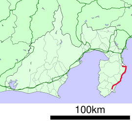
The Izu Kyūkō Line (伊豆急行線, Izu Kyūkō-sen) is a privately owned railway line of Izukyū Corporation in Shizuoka Prefecture, Japan
The line approximately parallels the eastern coast of the Izu Peninsula, a tourist district noted for its numerous hot spring resorts and golf courses, between Itō Station in Itō and Izukyū-Shimoda Station in Shimoda. The line opened in 1961.
Since March 13, 2010, PASMO and Suica cards are accepted on the line.[1]
Basic data
- Track: single
- Railway signalling: Automatic (ATS-Si, compatible with East Japan Railway Company (JR East) ATS-SN.)
History
Initial plans called for the Japanese National Railways (JNR) to build a spur line linking Atami on the Tōkaidō Main Line with Shimoda. However, funding was limited in the 1930s due to a combination of a tight fiscal policy under Prime Minister Osachi Hamaguchi during the Great Depression, and a number of technical issues.
On March 30, 1935, the initial 8.7km section of the Itō Line linking Atami with Ajiro was opened. The second (8.3km) section from Ajiro to Itō was opened on December 15, 1938. Both sections were electrified at 1500 VDC when opened. Further work was delayed, and then canceled due to the outbreak of World War II.
Construction south of Itō resumed when the private-sector Tokyu Corporation acquired the rights to complete the line to Shimoda and established the Izukyū Corporation to manage construction and operations of this section. The line to Shimoda opened in 1961.
Operation
The northern terminal station for the Izu Kyūkō Line is at Ito Station, from which local trains depart for the southern terminal station of Izukyū-Shimoda. However, several varieties of limited express trains operated by JR East originate at Tokyo Station travel via the Itō Line tracks to Ito, and then terminate at Izukyū-Shimoda. These include the Odoriko and Super View Odoriko named trains. Similarly, the Resort Odoriko operated by the Izu Kyūkō Line also makes the same run, but using different rolling stock.
Station list
| Station Name |
Japanese | Distance from Itō (km) |
Transfers | Location | |
|---|---|---|---|---|---|
| Town/City | Prefecture | ||||
| Itō | 伊東 | 0.0 | JR East: Itō Line | Itō | Shizuoka |
| Minami-Itō | 南伊東 | 2.0 | |||
| Shizuoka | 川奈 | 6.1 | |||
| Futo | 富戸 | 11.5 | |||
| Jōgasaki-Kaigan | 城ヶ崎海岸 | 13.9 | |||
| Izu-Kōgen | 伊豆高原 | 15.9 | |||
| Izu-Ōkawa | 伊豆大川駅 | 20.9 | Kamo District, Higashiizu | ||
| Izu-Hokkawa | 伊豆北川駅 | 22.9 | |||
| Izu-Atagawa | 伊豆熱川 | 24.3 | |||
| Katase-Shirata | 片瀬白田 | 26.1 | |||
| Izu-Inatori | 伊豆稲取 | 30.3 | |||
| Imaihama-Kaigan | 今井浜海岸駅 | 34.2 | Kamo District, Kawazu | ||
| Kawazu | 河津 | 35.3 | |||
| Inazusa | 稲梓 | 40.7 | Shimoda | ||
| Rendaiji | 蓮台寺 | 43.4 | |||
| Izukyū Shimoda | 伊豆急下田 | 45.7 | |||
See also
References
This article incorporates material from the corresponding article in the Japanese Wikipedia


